AbandonedNYC
staten island
Scouring the “South Pole” of New York
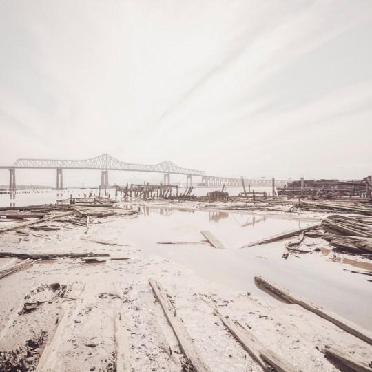
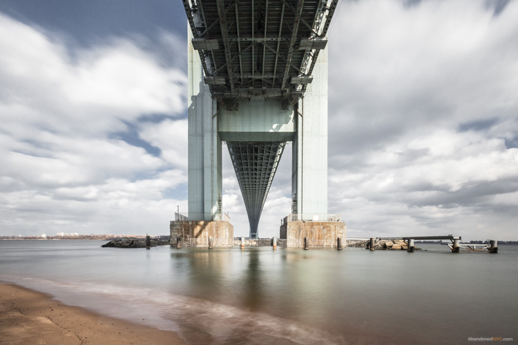
Rotted pilings beneath Outerbridge Crossing, with views of Perth Amboy, NJ.
From St. George, ride the Staten Island Railroad to the end of the line and you’re only a short walk from the southernmost point in New York State, at the mouth of the Arthur Kill. The name of the waterway stirs the imagination, but its Dutch origins are benign. Achter kill means back river or channel, in reference to its location at the “back” of Staten Island. Intriguingly, the route was carved out by an ancestral iteration of the Hudson River. Glacial activity altered the course to its current position, but the vestigial strait remained, isolating a sneaker-shaped land mass. Staten Island was born.
The Conference House
A stone’s throw from the so-called “south pole” of New York State, there’s an impressive bit of Revolutionary War history known as The Conference House. The name refers to a peace conference held there on September 11, 1776 between British commander Lord Howe and representatives of the Continental Congress, Benjamin Franklin and John Adams among them. Over the course of the three hour meeting, Howe urged the men to put aside their little rebellion. (They declined to do so.)
True to its contrarian nature even in revolutionary times, the borough was a loyalist stronghold, warmly greeting British troops upon their arrival. Hundreds of islanders enlisted in the British army as the conflict escalated. George Washington himself called the Staten Islanders “our most inveterate enemies.” John Adams was less generous, labeling them “an ignorant, cowardly pack of scoundrels, whose numbers are small, and their spirit less.”
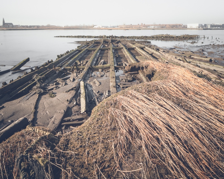
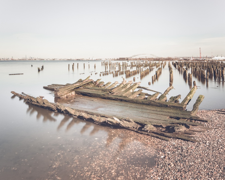
Low tide in the Arthur Kill reveals the remains of wooden ships.

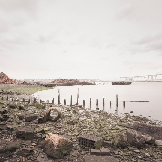
The borough is home to several lesser-known “boat graveyards” in addition to the famous Rossville salvage yard.
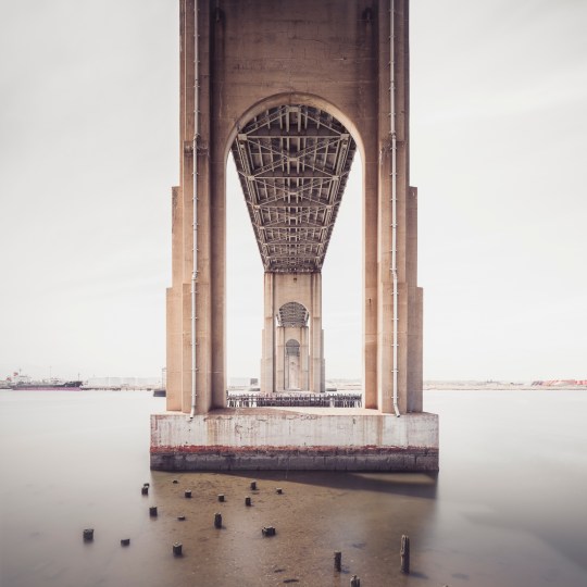
Tracing the Arthur Kill past the quaint historic houses of Tottenville, we enter into wilder territory and arrive at the base of Outerbridge Crossing, which spans the Arthur Kill between Charleston, SI and Perth Amboy, NJ. New Yorkers could be forgiven for assuming the name refers to its status as the most remote bridge in New York City, but it’s actually named for Eugenius Harvey Outerbridge, the first chairman of the Port Authority of New York and a resident of the borough. “Outerbridge Bridge” wouldn’t do, so they deemed it a “Crossing.”
Wandering these regions can be treacherous if you don’t plan ahead. As the tide ebbs and flows, open shoreline gives way to mud and water, leaving you with no way out but the head-high reeds of the marsh. In nesting season, geese are liable to attack (speaking from experience here). But for those willing to brave the wilderness, there are rewards. The fabric of the city dissolves on the outermost edges of Staten Island, and the ground is a layer cake of archaeological finds.
The remains of the Atlantic Terra Cotta Company factory line the shores of the Arthur Kill at the end of Ellis Street.
One area of interest at the foot of Ellis Street marks the site of The Atlantic Terra Cotta Company, which made colorful architectural ornaments for many notable city buildings, including the Flatiron and the Woolworth. It closed down in the 1940s and was demolished soon after, but much of the old factory is still there in the form of rubble. Enterprising beachcombers can still find Atlantic Terra Cotta tiles if they hunt long enough. (The old adage “leave no stone unturned” applies here, as many of the most intricate pieces are one-sided.) I managed to find a beautiful acorn-themed tile with an ATLANTIC stamp, but plain bricks were more readily available.
Many of them are inscribed with the names of long-gone manufacturers, resembling fragments of time-worn tombstones. Thanks to these markings and a devoted online community of brick collectors, it’s a simple matter to pinpoint their origins. The “RICHMOND” and “ATLANTIC” bricks were made in Staten Island, but others trace their ancestry to Brooklyn or New Jersey. Some are from much farther afield—“RELIANCE” Bricks hail from Texas; “MO REX” from a town called Mexico, Missouri. How all of them ended up here is a bit of a masonry mystery.
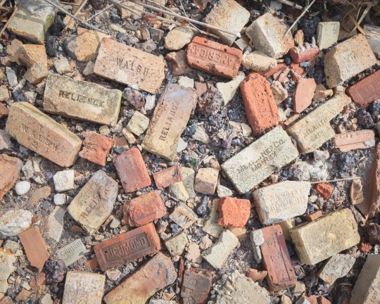
Manufacturer’s marks on the bricks point to a wide range of origins.
Just inland, marshes give way to roving woodlands that hold secrets of their own. If you look into any patch of untended forest, and many of the front yards, you’ll find a wealth of rusty relics of the one man’s treasure variety. While there isn’t much history to glean from them, they are fascinating to look at. A natural area known as Sharrot’s Shoreline was once filled with mountains of scrap metal and scores of abandoned cars. Only a few remain today after cleanup efforts by the city. What’s left is a serene nature reserve that would thrill most bird-watchers, though they might have a hard time finding a way in.
Nearby, a deserted graveyard of auto parts marked one of my most surprising finds to date. Chief among the relics was a group of corroded buses, apparently from the 1960’s. While the scene has an ancient air, the plot was the site of a multi-generational family business until quite recently, according to a neighbor who gave me a stern warning for trespassing on private property. (For that reason, I wouldn’t advise seeking them out for yourself.)
This has been the second installment of a series of posts on the edges of Staten Island. Next up, we’ll continue our trip down Arthur Kill Road, delving deeper into the history of Charleston and the “haunted” Kreischer Mansion. See more photos from the project here.
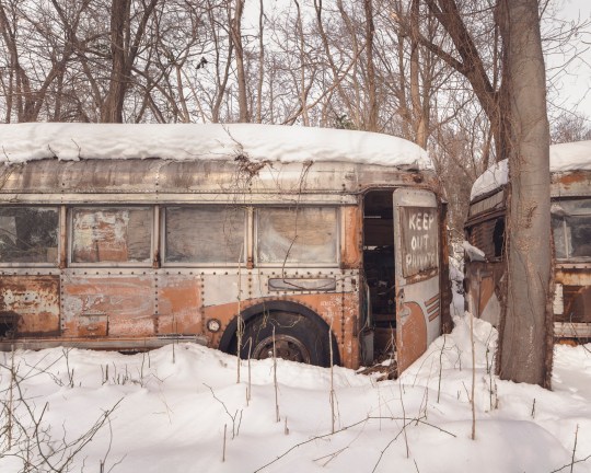
A foot of snow covers a “graveyard” of auto parts…
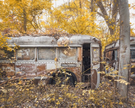
..pictured here in the fall.
Ghosts of Kreischerville

Kreischer Mansion
At Kreischer Street, Arthur Kill Road verges sharply right and branches into a tangle of dead-ends, hemmed in by woods and wetlands. The route winds into the heart of Charleston, Staten Island, a sensible industrial district given to sudden flights of fancy. Out here, stables and shooting ranges rub elbows with haunted mansions and sunken ships. It’s equal parts Wild West and Gothic Horror.
In this corner of the borough, street names and gravestones echo with the same few family names, but one name—Kreischer—rises above the rest. It’s written on the very building blocks of the oldest structures, etched into the walls of the local tavern and stamped into the sidewalks. Because the town was built of Kreisher bricks, by Kreischer bricks, and for Kreischer bricks. And before it was Charleston, it was Kreischerville.
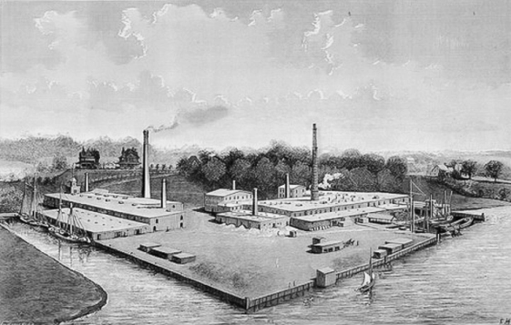
The Kreischer Fire-Brick Works, pictured in the late 19th century.
Born in a small Bavarian village, Balthasar Kreischer emigrated to New York City in 1836, a year after a great fire destroyed much of Lower Manhattan. He quickly found employment rebuilding the burned district, taking a special interest in the construction of baker’s ovens. With a business partner he opened a brick works on the Lower East Side in 1845. His fire-proof bricks were made to withstand high temperatures in chimneys and furnaces, and required a specific type of raw material known as “fire clay.” Following the discovery of rich clay deposits in southwest Staten Island in the 1850s, he relocated his business to be close to the source.
The new location was a secluded section of the borough called Androvetteville, after a prominent local family. Balthasar bought up the clay pits and the waterfront on which to build his factory, and within a few decades the sleepy community of oystermen and mariners grew into an industrial boomtown, producing 20,000 bricks a day. As the brick works prospered, the neighborhood came to be known as Kreischerville.
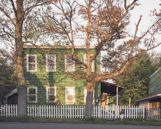
A row of worker’s houses sits frozen in time on Kreischer Street


Kreischer took a paternalistic approach to leadership, providing housing for his workers and monetary aid during periods of sickness or financial distress. In return, he expected his employees to maintain appearances, keeping their yards and houses tidy for the benefit of all. Four of the original worker’s houses are still standing today, designated New York City landmarks in 1994. Some appear to be unoccupied, with rusted out cars from a bygone era parked in the driveway. The scene is startlingly out of step with the present, right down to the sidewalks. (They were paved with Kreischer bricks over a century ago.)
Kreischer retired in 1878, ceding control of the company to his three sons. Edward and Charles stayed in Staten Island and a third brother took the helm of the company’s headquarters in Manhattan. Shortly before his death in 1886, Balthasar gifted the town a new church edifice, which is still in existence, and commissioned a pair of mirror-image Victorian mansions on a hilltop overlooking the factory, intended as residences for Charles and Edward. Only Charles’ house remains today—a fire claimed Edward’s in the 1930s.
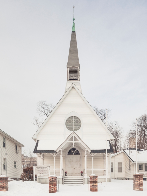
The church was a gift to the community from Balthasar before his death.
Edward himself met a tragic end in 1894, when he was found dead not far from the factory of a self-inflicted gunshot wound. Publicly, his brother George was at a loss for what had led to Edward’s decision. But friends of the deceased told a different story, pointing to friction between the two brothers. After Balthasar’s death, the business was divided equally between his five children, but Charles had moved quickly to acquire a controlling stake in the company by purchasing the interest of his two sisters.
Diminishing returns at Kreischer and Sons may have been another factor. The factory was sold in foreclosure in 1899 and closed in 1906. (Many workers found employment at the nearby Atlantic Terra Cotta Works, outlined in a previous post.) As time wore on, “Kreischerville” was renamed “Charleston” in response to anti-German sentiment during World War I. Nature gradually reclaimed the old clay quarries, transforming them into small ponds which became the namesake of Clay Pit Ponds State Park. Meanwhile, Kreischer House stood watch on Kreischer Hill, becoming a New York City landmark in 1968.
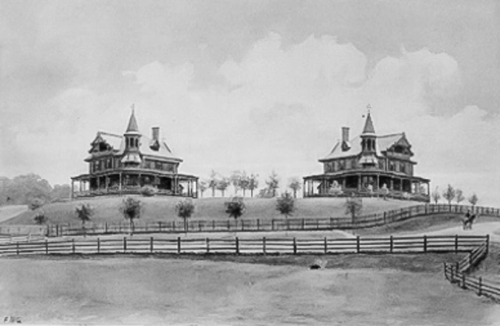
Only one Kreischer Mansion is extant today. Edward’s (on the left) was destroyed by fire.
As the building aged and a gulf of time distanced Edward’s untimely end, the house gradually ripened into the “haunted mansion” it was always destined to be. But it wasn’t until 2005 that its status was cemented into the public consciousness. That year, Kreischer Mansion gained notoriety as the setting of a real-life horror story—a gruesome mob murder perpetrated by none other than the house’s caretaker.
The man was paid $8000 to carry out a Sopranos-style hit of a Bannano crime family associate who’d run afoul of the group. The New York Times reported the grisly details in 2006: “The victim was lured to a secluded landmark, a Victorian mansion on a hilltop on Staten Island, but he proved hard to kill. When an effort to strangle him failed, he was stabbed, then dragged to a nearby pond and drowned. His body was dismembered with hacksaws and incinerated in the mansion’s furnace.”
The drowning actually occurred not in a pond, but in a small reflecting pool in front of the mansion, lined with yellow Kreischer bricks.
Kreischer Mansion
Unaware of the incident, the estate’s owner moved forward with renovations that were already underway at the time of the murder. By the time the F.B.I. got wind of the killing and moved to search the mansion for evidence, the furnace had been replaced. The Ohio-based developer had planned to build a community for the elderly called “Kreischerville” with the mansion as its centerpiece. But the plans were scrapped in 2012 and the property was put on the market for $11.5 million, with the house accounting for $1.6 million of the overall value. The 5-acre property is currently back on the market for $12 million.
For now, the house sits empty as ghost stories swirl around it, concentrating on Edward’s grieving widow, despite the fact that she never actually lived in the house. There are signs that the mansion is starting to embrace its reputation. In 2015, it opened its doors on Halloween night for an interactive theater piece. Last year, the house closed out the first season of a ghost hunting show called “Paranormal Lockdown”. The claims are dubious, but ultimately harmless. After all, a sordid history is a remembered history. Kreischer Mansion may stand for another hundred years, or longer, as one of Staten Island’s most compelling links to its 19th century past.
End of Androvette Street
Approaching the “Forgotten Borough”
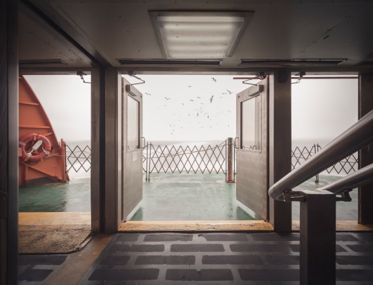
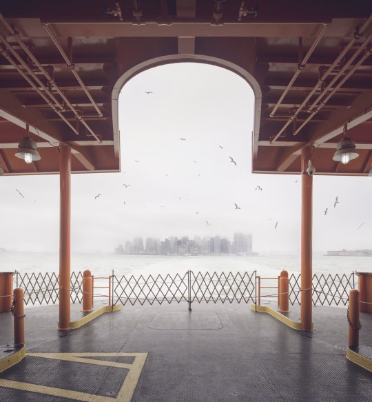
Seagulls follow in the wake of the Staten Island Ferry.
Hello friends, its been a while. I’ve been on a bit of a hiatus from poking around abandoned buildings, but I’m back now with something a little different. This is the first installment of a series on Staten Island—an area of the city that tends to go unnoticed, but is very much worth exploring.
For the unfamiliar, Staten Island stands with Manhattan, Brooklyn, the Bronx, and Queens as one of the five boroughs that make up the city of New York. It is the third largest and least populated of the five. Its identity has always been somewhat distinct from the city at large, due in part to its geographical isolation. Prior to the construction of the Verrazano Bridge in 1964, no crossing existed between Staten Island and any other borough. It remains something of an outlier today, with a suburban nature and right-leaning political tilt. A record of neglect from city government has earned it the oft-repeated title “the forgotten borough,” and the name has stuck.
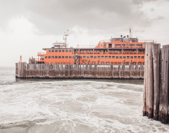
The Staten Island Ferry departs from Lower Manhattan.
From a Manhattan-centric point of view, a trip to Staten Island begins with a ride on the Staten Island Ferry. Over 21 million passengers embark on the 25-minute journey from Lower Manhattan to St. George each year. With dramatic views of the Statue of Liberty and the surrounding harbor, it’s a well-known attraction for New York City tourists. The ride is offered free of charge by the city’s Department of Transportation, but that hasn’t always been the case.

An engraving of the 1871 “Westfield” disaster.
Back in the 18th century, sailboats manned by private individuals competed for fares between Manhattan and Staten Island. In 1817, the first mechanically powered ferry service went into operation, under the direction of Captain John de Forest of the Richmond Turnpike Company. His brother-in-law Cornelius Vanderbilt took over in 1838. Existing ferry service proved inadequate as Staten Island developed, and accidents were common.
In 1871, a boiler explosion on one of the ferries claimed the lives of more than 85 passengers. Jacob Vanderbilt, the president of the Staten Island Railway at the time, was charged with murder, but never convicted. In 1901, a ferry operated by the Staten Island Rapid Transit Company collided with a Jersey Central ferry and sank into the harbor soon after departing the port at Whitehall. Though the disaster was far less deadly than the 1871 episode, city authorities used it as justification to seize control of the service by 1905.
The iconic orange color of the ferries was adopted in 1926, to increase their visibility in heavy fog and snow.
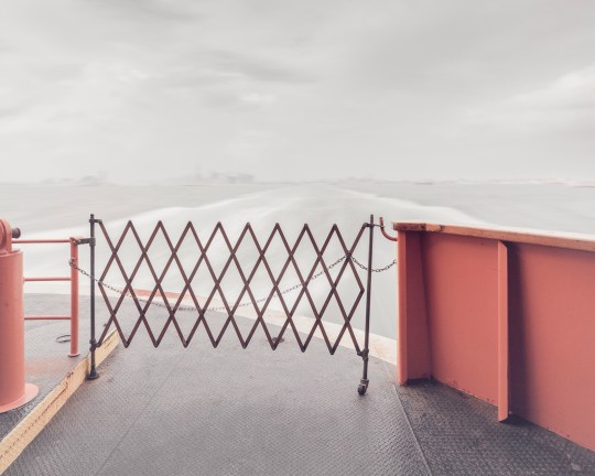
Leaving Manhattan.
A nickel fare was the rule through most of the 20th century, but was increased in 1975 to a quarter, and in 1990 to 50 cents, causing an uproar among borough residents. Coupled with mounting grievances over the Fresh Kills Landfill on the island’s west shore, the fare hike gave rise to a secession movement, which culminated in the passage of a non-binding referendum to make Staten Island an independent city in 1993.
Efforts to secede were subdued by the election of Mayor Rudy Guiliani, who rode to power due in part to overwhelming support from Staten Island voters, many of whom had been won over by his promises to close the landfill and do away with the fare. He followed through on both, abolishing the fare in 1997 and closing the landfill in 2001.
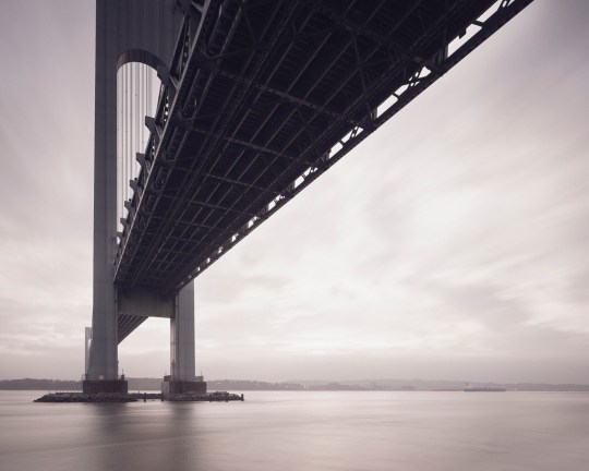
The Verrazano Bridge was the longest suspension bridge in the world at the time it was built.
While the ferry has played a significant role in the history of Staten Island, the construction of the Verrazano-Narrows Bridge has arguably had the greatest impact on its development. The story of Staten Island can generally be understood in terms of two epochs—before and after November 21, 1964, the day the bridge first opened to traffic.
Long-time residents speak longingly of Staten Island before the bridge—when country roads meandered through sweeping forests, quiet beach communities, and open expanses of farmland crawling with nanny goats. In the 19th century, full-time islanders lived side by side with some of the city’s wealthiest residents. As the industrialized city minted new millionaires, many of them looked to the rolling green hills of Staten Island as a scenic escape.
The nature of the borough was permanently altered as the Verrazano-Narrows Bridge prompted a mass migration of newcomers from overpopulated Brooklyn. The influx covered farms and forests with mile upon mile of tract housing, plaguing the island with traffic problems that persist to this day.
The official name of the Verrazano-Narrows Bridge includes a misspelling of its namesake, Florentine explorer Giovanni da Verrazzano.
As much as the borough has transformed over the years, it has retained its essential otherness. Crossing the harbor by ferry or bridge signals a psychological detachment from the urban environment of New York as we know it. In the hum of traffic, or the roar of surf, the city melts away and you enter a new frontier. Beyond and in-between the strip malls and cookie-cutter houses, scattered remnants of an older, more pastoral Staten Island await. There, Times Square feels a million miles away.
Over a series of upcoming posts, I’ll be examining the many artifacts and oddities that litter the far-flung edges of the borough, and sharing the history behind them. In the meantime, you can visit my website to see more photos from the project, “Arthur Kill Road.”
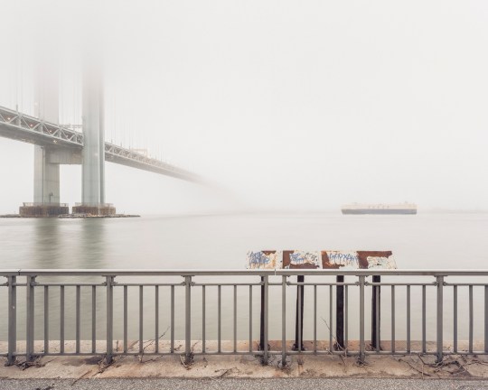
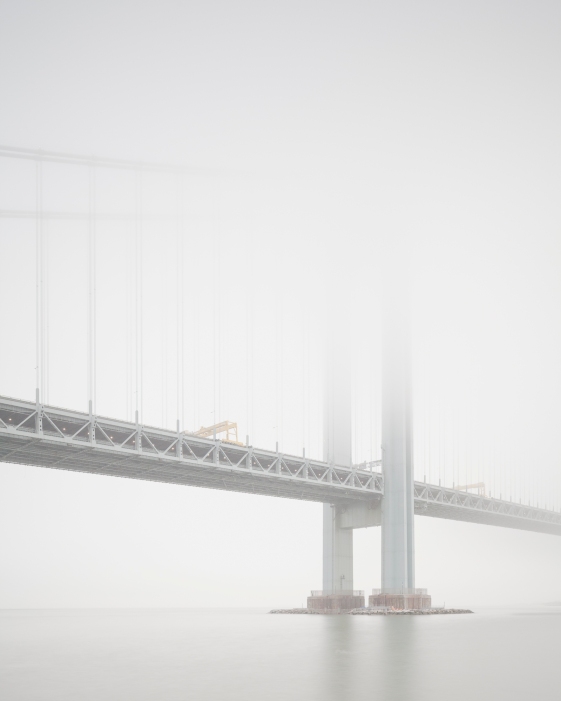
View of Staten Island obscured by fog, from Bay Ridge, Brooklyn.
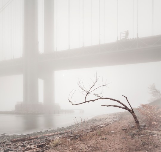
An early morning at Fort Wadsworth, on the opposite side of the span.

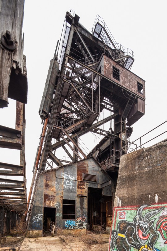
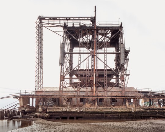
Port Reading’s McMyler Coal Dumper
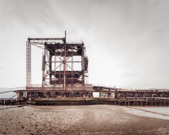
The abandoned McMyler Coal Dumper in Port Reading, NJ
There’s a stretch of the Arthur Kill between Rossville, Staten Island and Port Reading, New Jersey that’s something of an abandoned wonderland. From the New Jersey side, the horizon is dominated by the twin natural gas tanks of Chemical Lane, and the famous Staten Island Boat Graveyard is plainly visible just across the water. But towering over the scene is a structure that rivals both with its staggering beauty and power—the McMyler Coal Dumper.
Actually, it would be more accurate to call it a McMyler Coal Dumper. It was one of many nearly identical structures built on the shores of the New York Harbor in the early-to-mid 20th century, including two on Pier 18 in Jersey City. But the Port Reading site is notable for being the last one standing in the New York area. It was constructed in 1917, making it 99 years old at the time of this post.
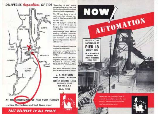
A 1957 ad for Pier 18 in Jersey City, which boasted two “Big Mac” McMyler Dumpers.
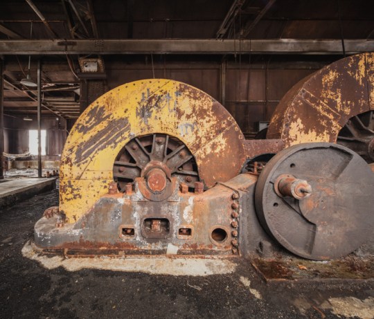
In a vast regional network of coal mines, breakers, railroads, and manufacturing hubs, these machines provided a vital link that helped fuel New York’s industrial age, transferring massive amounts of coal brought by rail from Pennsylvania and the Alleghenies into ships entering the harbor. A McMyler Dumper could unload a 72-ton car of coal every two and a half minutes, operating on a continuous loop for maximum efficiency.
Upon entering the pier, railroad “hoppers” carrying a full load of coal would be pushed up a ramp with a mechanism called a barney. Once in position at the base of the tower, the entire car and its contents would be lifted up on an unloading platform and tilted at 120 degrees, spilling the coal into an enormous “pan,” which funneled the material through an unloader chute and into the holds of outgoing barges. Once empty, the car would be lowered and pushed onto a kickback trestle by the next car in the line-up. These rails looked very much like a roller coaster, and they worked in a similar fashion, using the power of gravity to propel empty cars off of the pier and into the rail yards beyond. The contraption required twelve men to operate, and the work was risky. The brute force of the machine claimed many lives and limbs over the years.
A braver soul would have climbed the tower, but I was satisfied with the view from the pier.
The design stood the test of time, and the pier operated for over 60 years with nearly uninterrupted use (a fire caused considerable damage in 1951, but the unloader was quickly rebuilt.) With demand for coal declining, the machine dumped its last load in the early 80s, and has been steadily deteriorating ever since. Though there has been interest in designating the structure an historic site, its location on private property in an active industrial area has made it an unlikely candidate, and the cost of restoring or moving the structure would be prohibitive, to put it mildly. Unless new industrial development threatens the site, it will likely remain a picturesque ruin for another century before eventually collapsing into the Kill and vanishing into the muck.
That is lucky for the throng of Canada Geese who’ve made a surreal home out of the hulking relic. Though they’re nice to look at, I’ve never had a pleasant encounter with these creatures, and have been charged at by enough of them on the remote shores of the outer boroughs to know they mean business. This time around they were content to squawk and hiss their disapproval from a distance, but I would advise everyone to stay far away during nesting season, which is right around the corner.
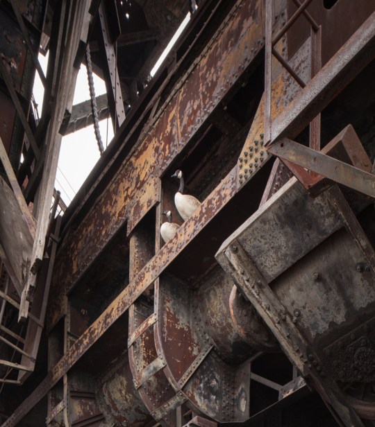
The self-appointed guardians of the coal dumper.
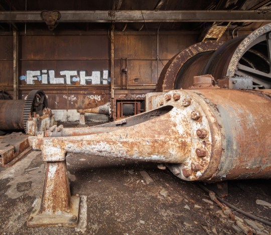
A pair of steam engines inside the machine room powered a cable drum…
…which controlled the “barney,” a mechanism used to push cars onto the unloading platform.
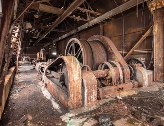
These cable drums raised and lowered the unloading platform. Much of the machinery has been removed by scrappers over the years.
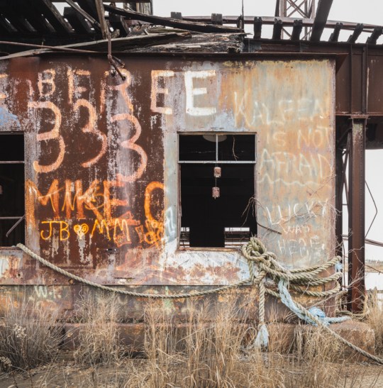
The place has a fair amount of graffiti, some quite old. Kaleen’s protestation on the upper right was particularly endearing.
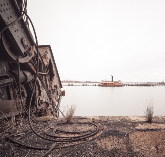
A derelict ferry boat sinks into the Kill on an adjacent pier.
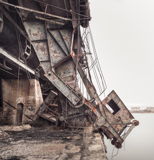
The pan and chute, pictured here, were left in an upright position until Hurricane Irene sent them crashing onto the pier below in 2011. An operator would have sat in the little chamber on the right. A pair of abandoned gas tanks in Rossville, Staten Island can be seen on the horizon.
Low Tide at the McMyler Coal Dumper.
You can see (a model of) a McMyler Coal Dumper in action in the following video:

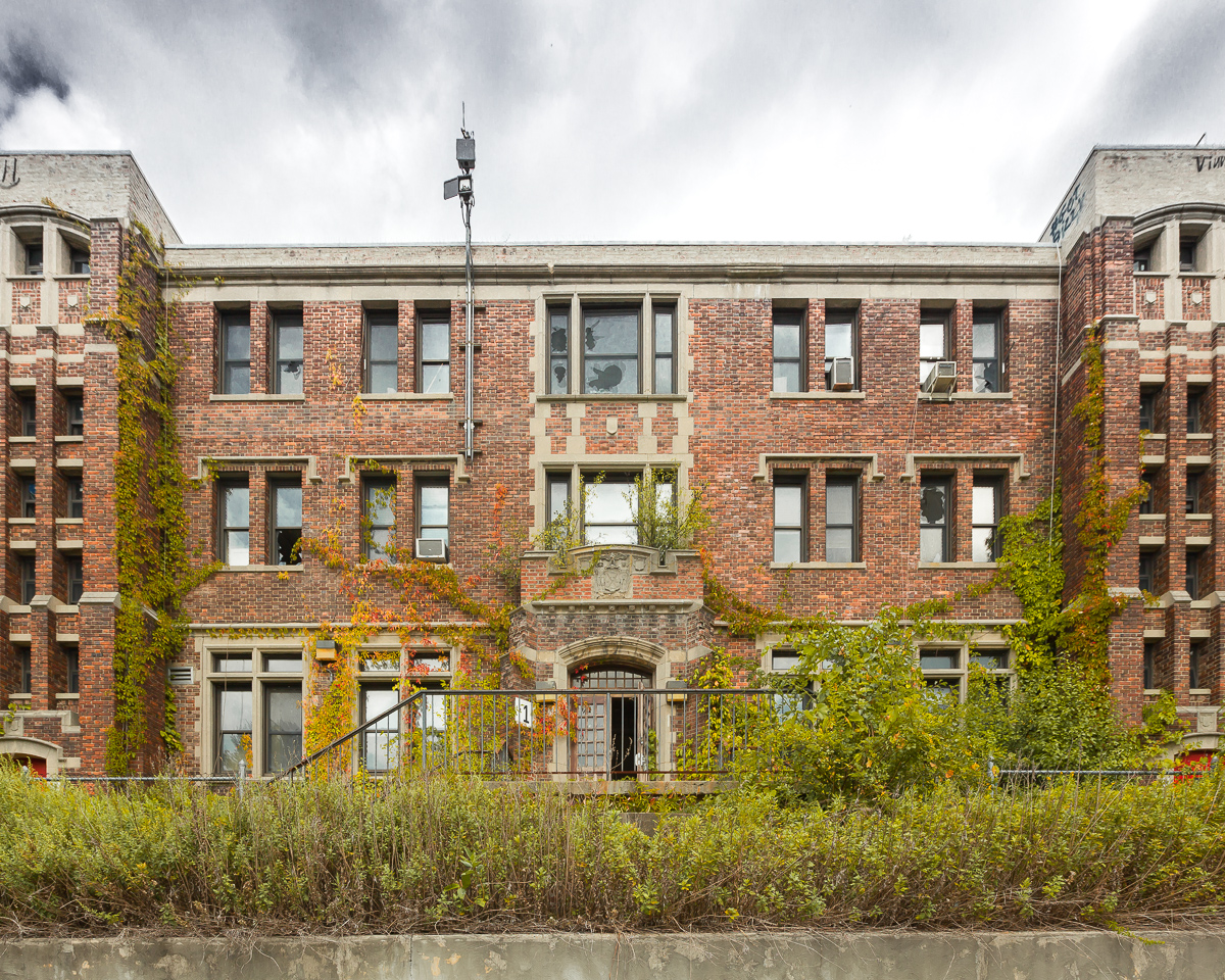
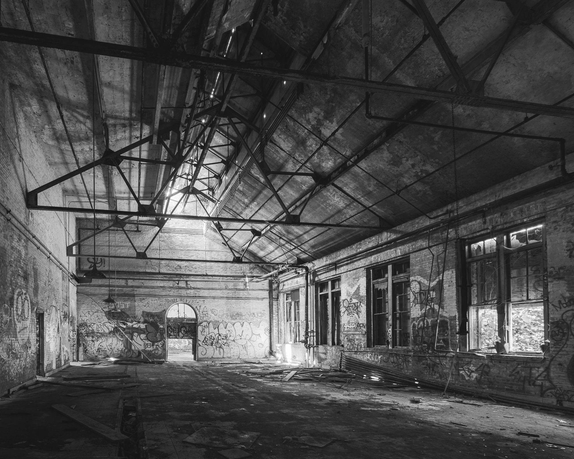
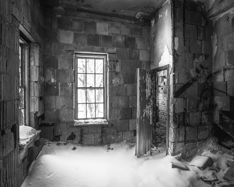
The Sea View Children’s Hospital
Forested views from a lower floor day room at Sea View Children’s Hospital.
At the turn of the twentieth century, tuberculosis was the second leading cause of death in the city and a major world health concern known to disproportionately affect the urban poor. In New York City, two-thirds of the 30,000 afflicted were dependent on city agencies for treatment. Growing concern from charitable organizations spurred the establishment of New York’s first public hospital designed exclusively to treat tuberculosis, care for the “sick, poor, and friendless,” and keep the epidemic under some measure of control by isolating sufferers from general hospitals. If you were diagnosed with tuberculosis in the early 1900s, your prognosis was grim. Lacking a cure, the only treatments thought to ease symptoms were fresh air, rest, sunshine, and good nutrition. A pleasant view was also considered essential for staving off depression. For this reason, hospital planners settled on a privately owned 25-acre hilltop parcel in rural Staten Island called “Ocean View,” just across from the already established New York City Farm Colony.
The plot was surrounded by a vast expanse of forested land (known as the Greenbelt today) which enabled the hospital grounds to expand as necessary. When Sea View Hospital was dedicated on November 12, 1913, the New York Times called it “the largest and finest hospital ever built for the care and treatment of those who suffer from tuberculosis.” The Commissioner of Public Charities claimed it was “a magnificent institution that is vast, ingenious, practical, convenient, sanitary, and beautiful, the greatest hospital ever planned in the world wide fight against the “white plague.” Though the new facilities effectively eased the suffering of tuberculosis patients and provided housing for the poor, little could be done to actually save lives in the long term. Most eventually succumbed to the disease.
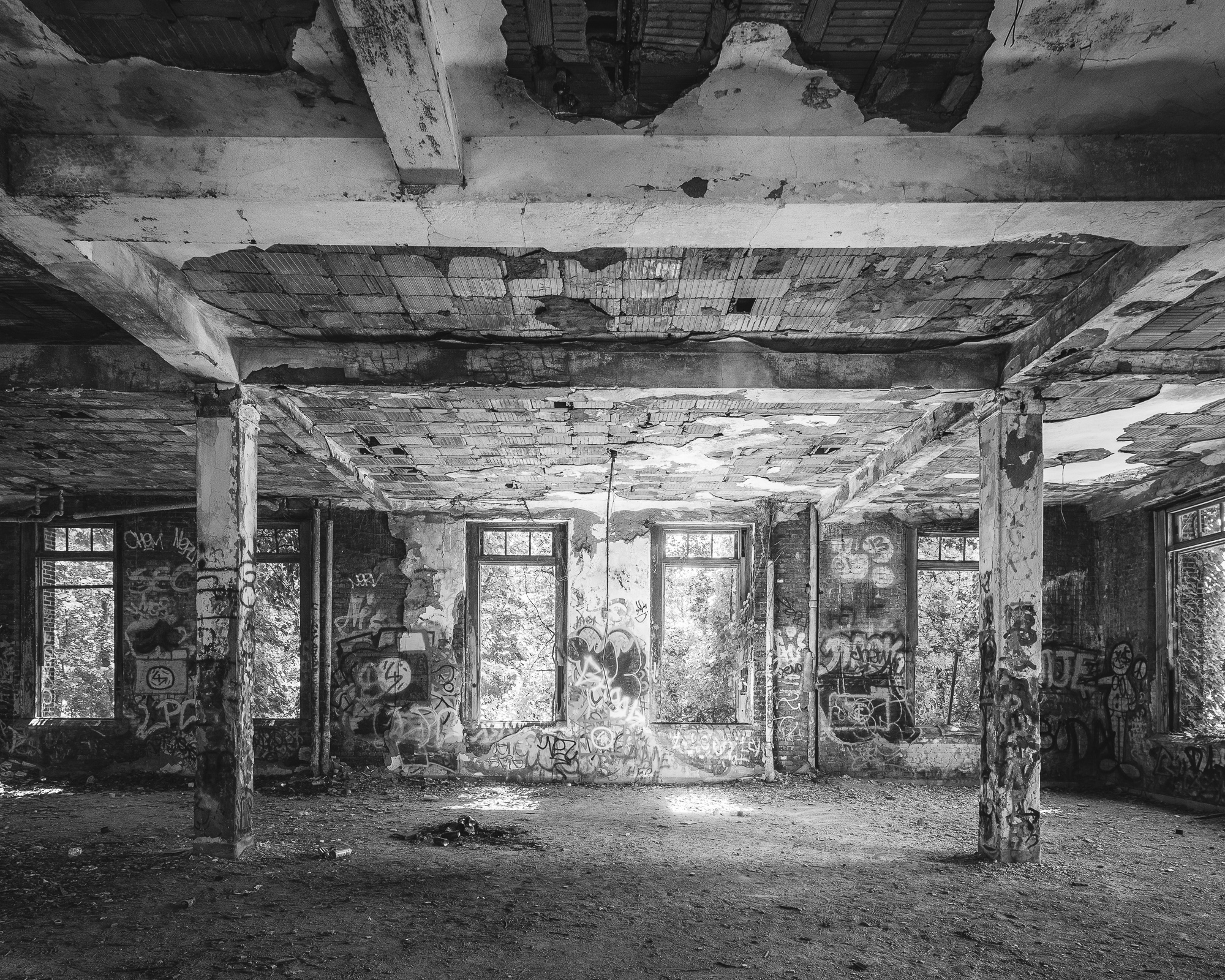
Saplings take root in a light-filled solarium on the top floor. (Prints Available)
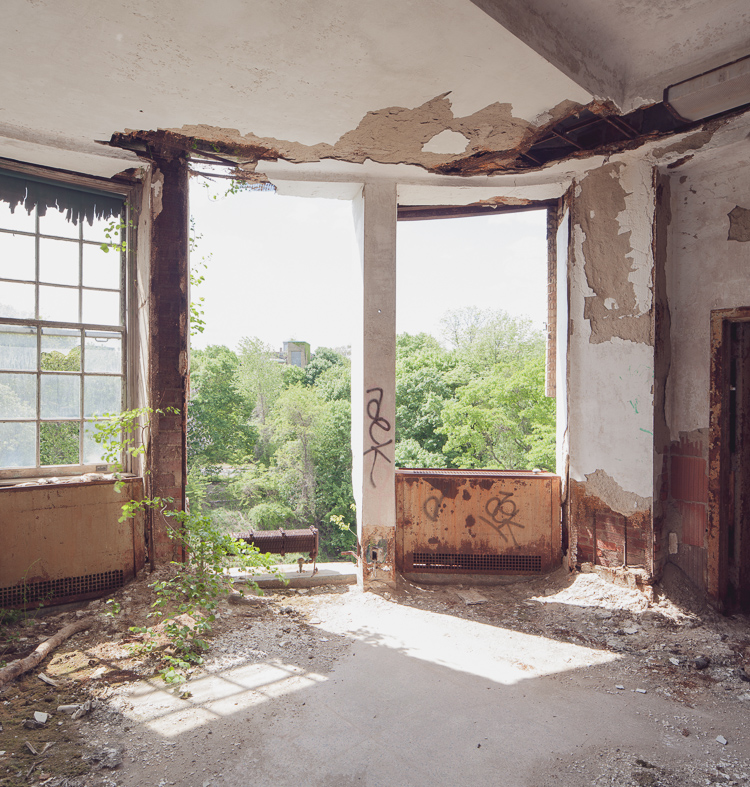
Two window fixtures had vanished, offering an unobstructed view of the surrounding woodlands.
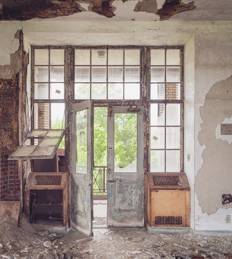
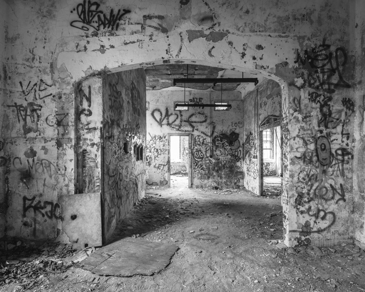
Doorway into an open-air pavilion.
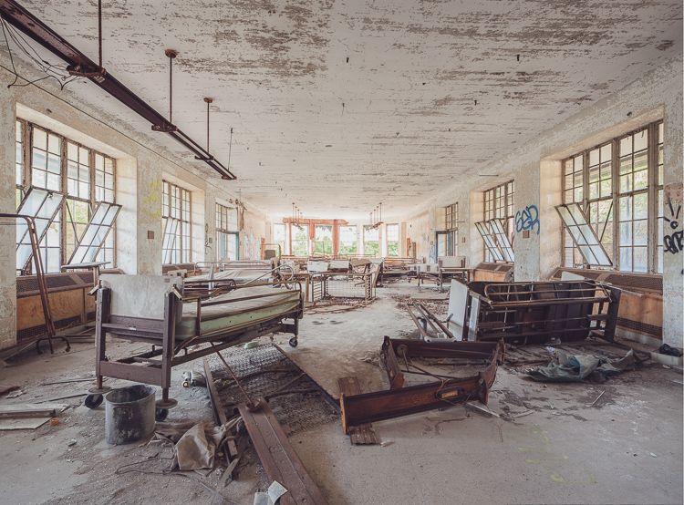
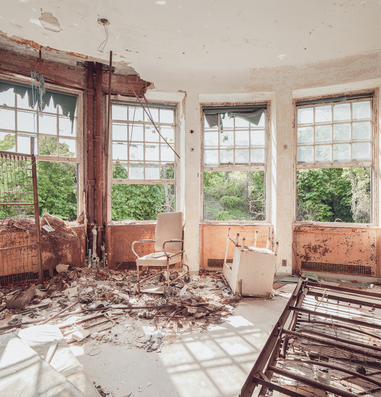
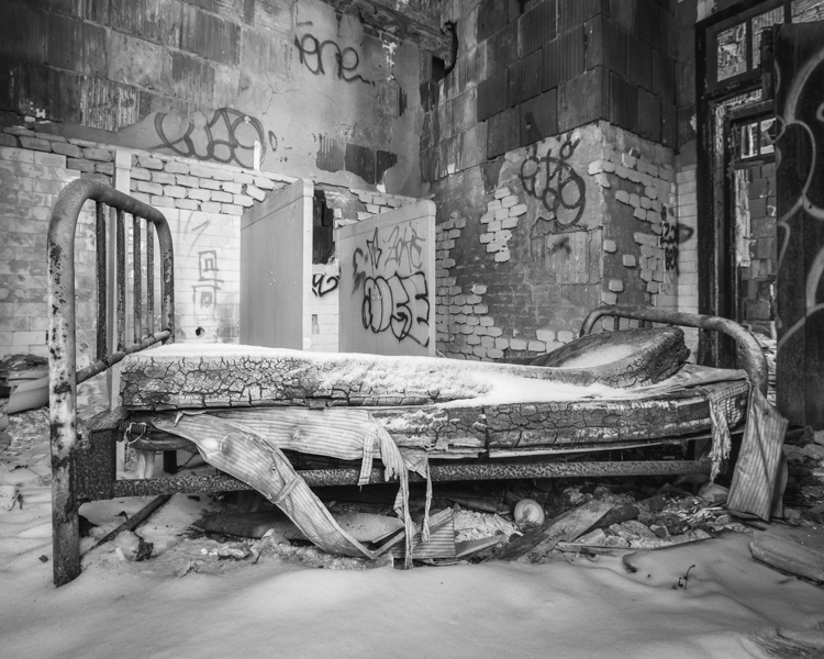
Hospital beds, cribs, and equipment left behind in a day room on a lower floor. (Prints Available)
In 1943, the development of the antibiotic streptomycin at Rutgers University led to a series of breakthroughs in the treatment of tuberculosis over the next decade, and much of that research took place at Sea View Hospital. The enthusiasm over these dramatic developments is captured in a 1952 report by the Department of Hospitals: “Euphoria swept Seaview Hospital. Patients consigned to death at the hands of the White Plague celebrated a new lease on life by dancing in the halls.” The transition was swift. By 1961, Sea View’s pavilions were practically emptied as patients miraculously recovered as a result of the new therapies. Today, a long-term care facility operates in several of the buildings and some structures have been repurposed by community agencies and civic groups, but much of the Sea View Hospital campus lies abandoned.
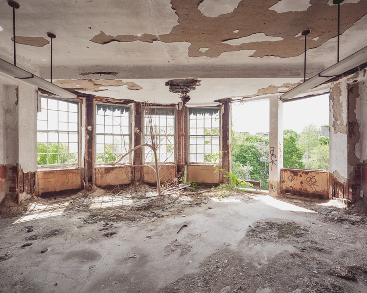
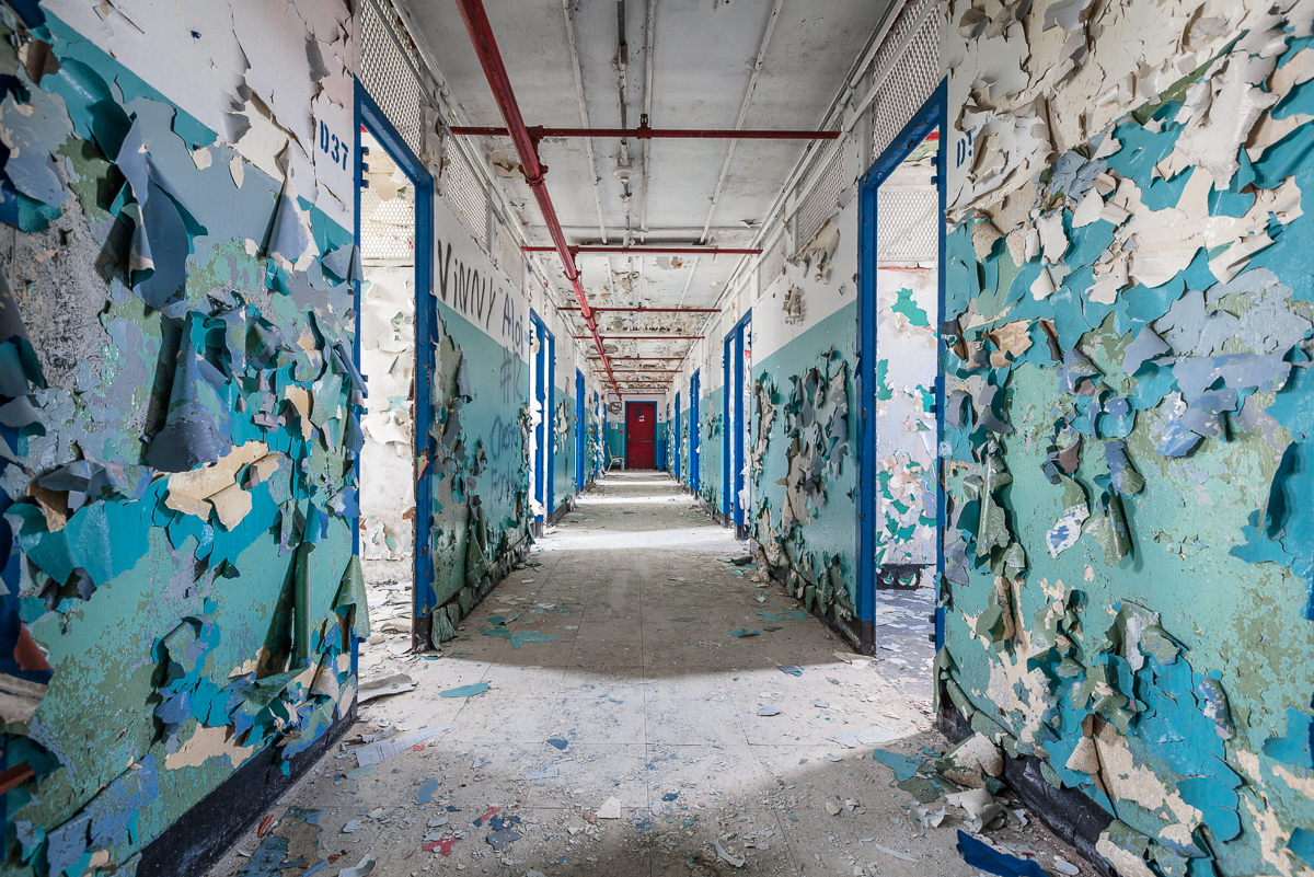
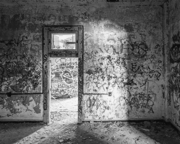
Past a fenced enclosure delineating the active section of the hospital, the grounds give way to the bramble-choked wilds of the Staten Island Greenbelt. The creepy ruins of the old women’s pavilions situated on the northern border are a popular detour on hikes from the neighboring boy scout camp. To the east lies the imposing Children’s Hospital, completed in 1938 and abandoned in 1974. Its spacious, window-lined solariums are typical of earlier Sea View wards, flanked on either side by open-air porches which were occupied by recovering patients 24 hours a day during the height of the epidemic. In an otherwise clinical Landmarks Preservation Commission report published in 1985, the researcher notes that “the building rises from a deep slope… Wooded surroundings, particularly dense to the east and south of the building, enhance the sense of isolation.” The view he’s describing is indeed one of New York City’s most surreal (pictured below in 2012).
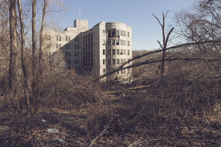
The ominous Children’s Hospital, seen from a hilltop on the grounds of Sea View Hospital.
Reuse of the structure seems extremely unlikely given the large number of abandoned buildings within the active hospital complex that would make better candidates for restoration. Area conservationists are fighting to keep the surrounding woodlands protected from developers by making it a permanent part of the Greenbelt network of natural areas, and the building itself is nominally protected from demolition as part of Sea View Hospital’s historic district designation. That doesn’t mean that the building won’t serve a purpose as it continues to crumble. As I’ve mentioned in previous posts, Staten Island teenagers have a long history of voraciously exploring (and vandalizing) their local ruins. With the renovation of the Willowbrook State School in the 1990s, the later demolition of the Staten Island Monastery, and the impending restoration of the New York City Farm Colony, the isolated, under-the-radar Children’s Hospital may be next in line as the site of that requisite rite of passage. Only time will tell.

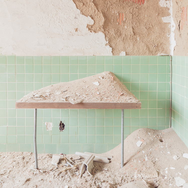
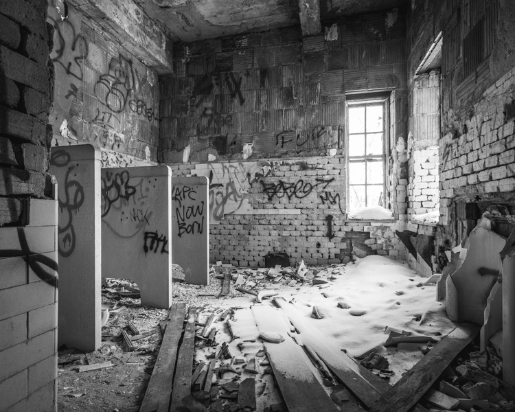
There’s little to suggest the building was used exclusively as a children’s hospital in its last years of operation.
Even the restrooms had windows for observation.
Drifts of plaster pile up on a table outside the darkroom.
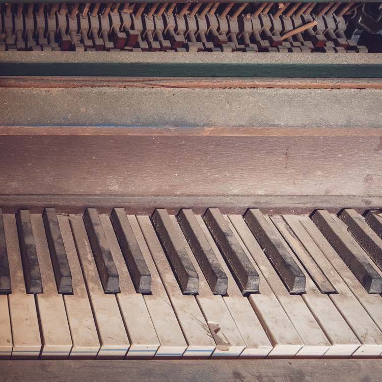
The upright piano, an abandoned hospital staple.

“Dixie Cup for Dentures.” The name says it all.
A storage room in the attic had been pillaged.
A steep staircase led to the upper reaches of the utility floors.
Lowers floors were boarded up, which always allows for the eeriest light. (Prints Available)
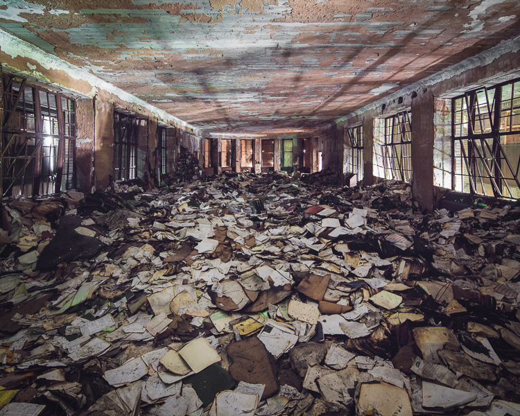
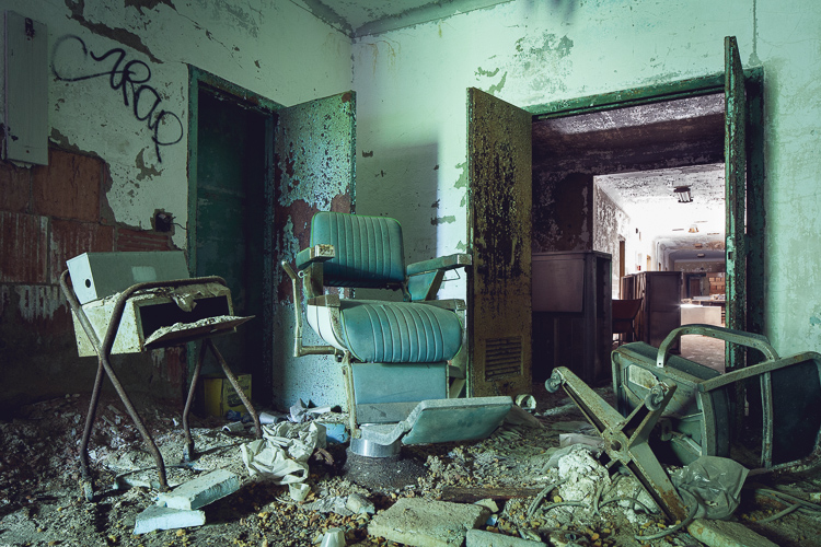
The last room I came to was the most surprising–a boarded-up dayroom piled several feet high with hospital records.
 IN OTHER NEWS… my friend Oriana Leckert‘s book “Brooklyn Spaces” is out this week. We’re a bit like kindred spirits, Oriana and I, but she goes more for the crowded, lively, and creative than the empty, eerie, and decrepit. The (50!) places profiled in the book show the authentic, human side of the global phenomenon that is “Brooklyn cool,” highlighting the heartfelt endeavors of a wave of culture makers that migrated to the borough for cheap rent and fashioned a network of bustling performance venues, art enclaves, and meeting places out of Brooklyn’s post-industrial landscape. Her obvious passion for offbeat museums, community gardens, communal living spaces, and out-there artist residencies is beyond infectious. Do yourself a favor and pick up a copy! And head to what I’m sure will be a raucous, sweaty launch party on May 30th.
Dredging the Archives + May 7th Library Lecture
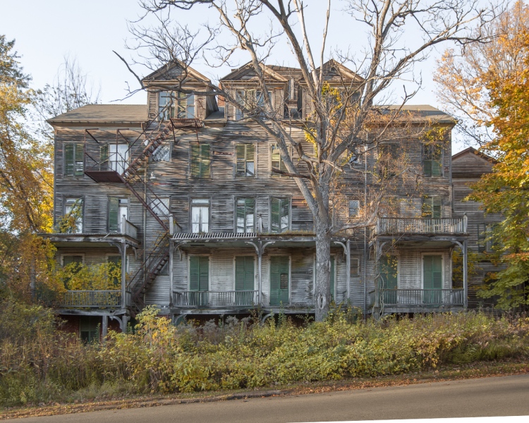
The spooky Walloomsac Inn in Benington, VT is actually occupied as a private residence.
On Thursday, May 7th at 6:30 PM I’ll be presenting at the Mid-Manhattan Branch of the New York Public Library as part of their Author @ the Library series. This will be the last book talk I’m giving for a while, so if you’ve missed out on past events and would like to attend, now is the time. The best part is it’s totally free, open to the public, and there’s no need to register or buy a ticket. Head here for more info.
Since its release at the end of January, the book has gotten a great response, particularly on the world wide web. For the highlights, check out these bits in The New York Times, Wired, Complex, and Slate, who toured the Jumping Jack Pump House with me and captured it on video back in March.
I have some exciting posts in the works for you, but for now I wanted to share some images from the archive that haven’t been shown here before–places that didn’t warrant a full post for one reason or another, often because I couldn’t get inside, didn’t have time to poke around, or there just wasn’t a lot to see. Some of them are quite interesting nonetheless. Enjoy!
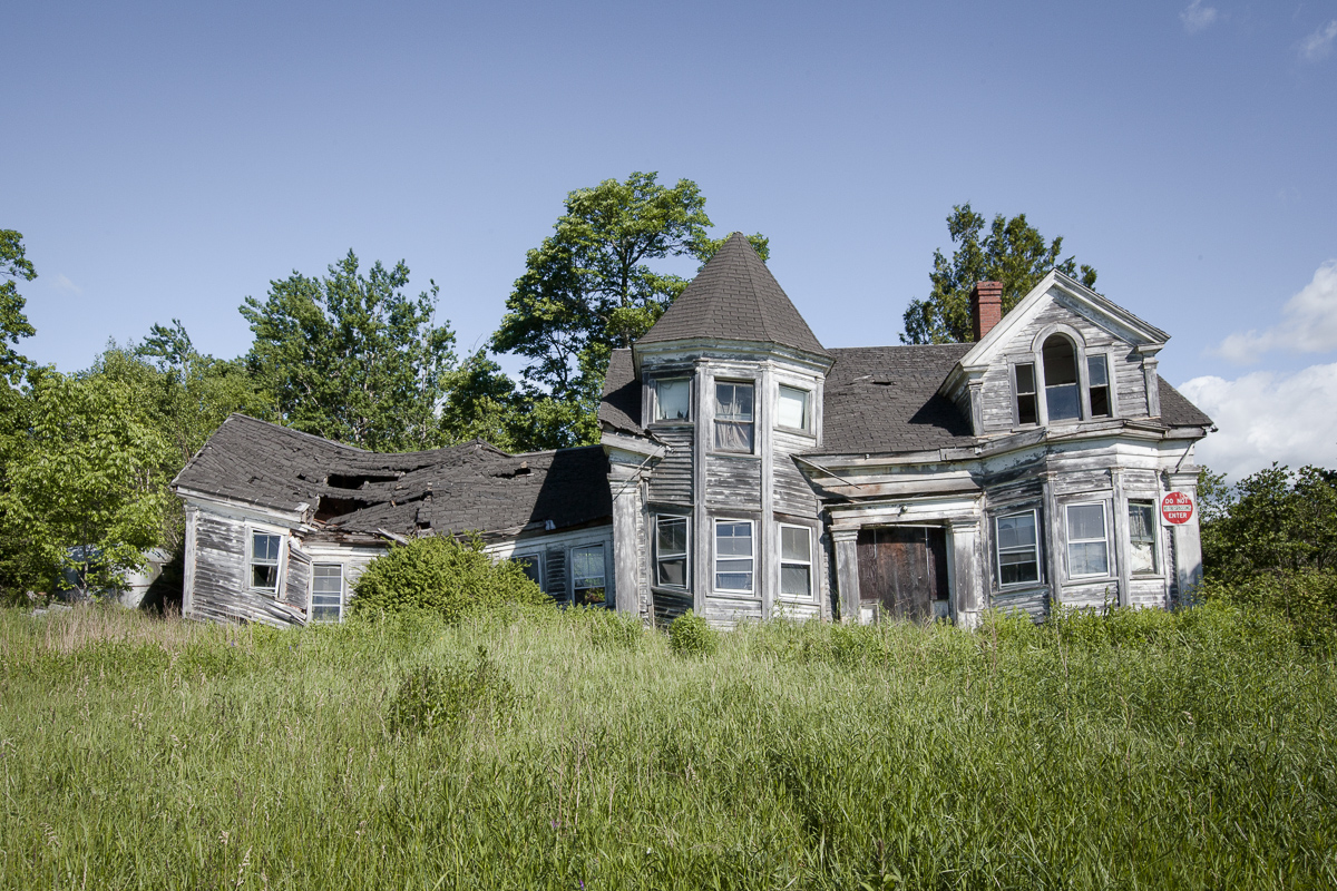
A striking abandoned house in Searsport, Maine.

Sea View Hospital, Staten Island.
La Guardia Men’s Shelter in Chester, New York…
…plenty of peeling paint inside, but not much else.
Ruined house in the Hudson Valley.
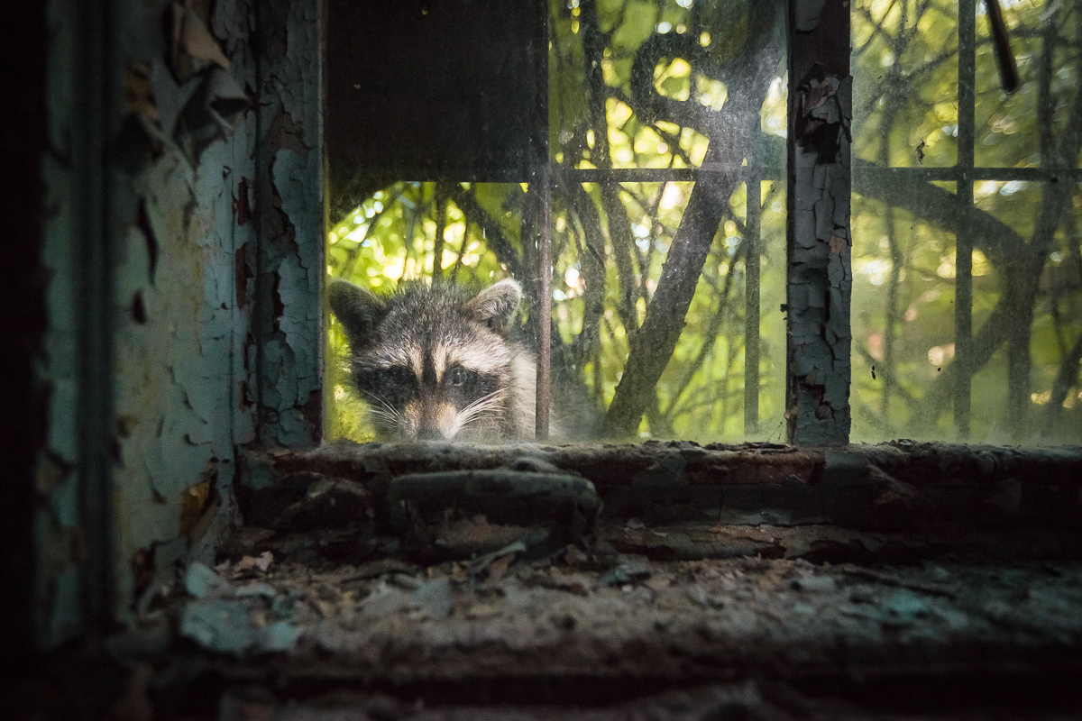
Raccoon peering into an abandoned asylum ward at Kings Park, LI.
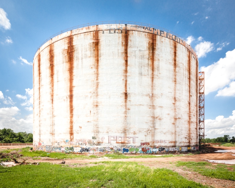
These mammoth LNG storage tanks in Rossville, SI were abandoned immediately after construction.
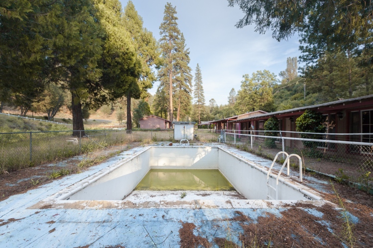
Ghost motel near Yosemite National Park.
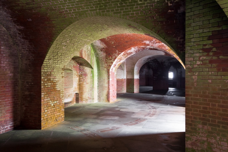
San Francisco’s Fort Point. (not abandoned)
An abandoned house in Queens, now demolished.

A well-preserved surgeon’s residence at the Brooklyn Navy Yard Hospital.

An abandoned carriage house in Newport, RI locals call “the Bells.”
Murder in Mariner’s Marsh

Mariner’s Marsh, on Staten Island’s North Shore.
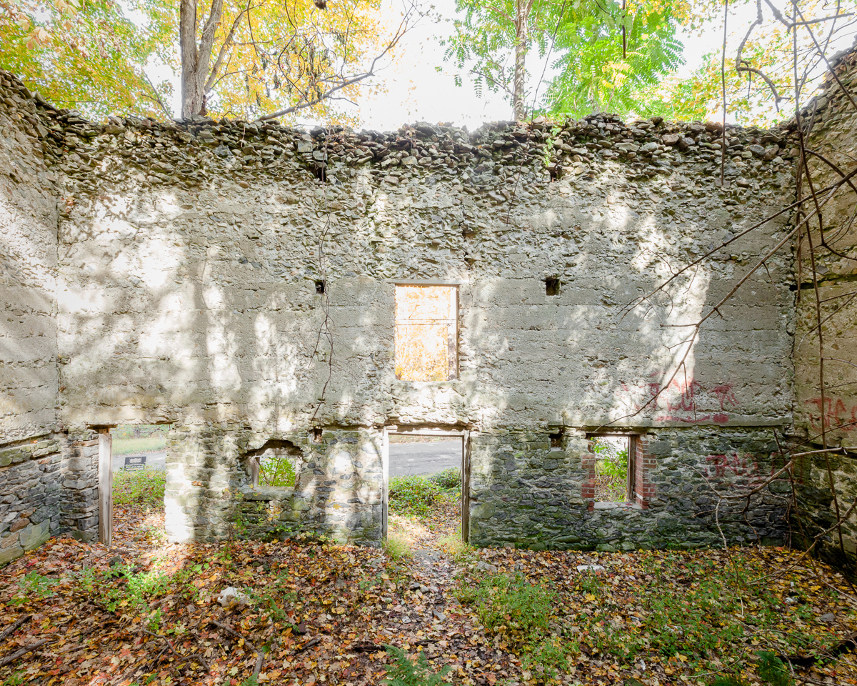
At a bend in Staten Island’s North Shore where the Arthur Kill gives way to the Kill van Kull, there’s a strange, desolate landscape that’s equal parts industrial wasteland and pristine wilderness. Here, an array of factories and freight lines are enveloped by a network of streams, swamps, ponds, and salt marshes, with place names like “Howland Hook” and “Old Place Creek” that wouldn’t feel out of place in a pirate story.
Mariner’s Marsh makes up 107 acres of the area, buffering a dense residential neighborhood from the sprawling New York Container Terminal with a wide expanse of green. Having endured a brief period of industrial use followed by 75 years of abandonment, the resulting wilderness is characterized by the vine-covered relics of factories that thrived on the spot 100 years ago. Even the Parks Department’s official signage describes the landscape as “eerie.” But the text rightfully avoids its darkest chapter, when in 1976 the tragic final act of a forbidden teenage love affair played out among the ruins of Mariner’s Marsh.
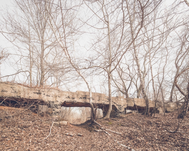
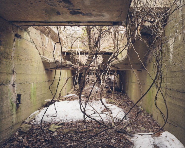
A trail leads walkers under an old concrete structure.
The ruins date back to the early 20th century, when the land was occupied by the Milliken Brother’s Structural Iron Works. Later, the foundry was converted to Downey’s Shipyard, which manufactured war ships, among other vessels. The factories closed down in the 1940s and have sat abandoned to this day. Wood components of the buildings have completely rotted away, but concrete pylons, pits, and passages remain. As the buildings deteriorated, the landscape transformed. Today, the former shipyard’s ten man-made basins function as reedy freshwater ponds. Elsewhere, the topography varies from pine and poplar forests to vine-gnarled swamps where wildlife and rare plants thrive.
A weathered birdwatching blind.

The requisite creepy doll head.
Mariner’s Marsh was acquired by the Parks Department in 1997, but it’s been “closed to the public during environmental investigation” for nearly a decade. The investigation in question took place in 2006 under the direction of the EPA, which found that a small area of the park contained a high concentration of hazardous materials stemming from its industrial age. Though it appears that some work has been done on the spot, it’s not clear when the park will reopen. In the meantime, warning signs haven’t stopped neighbors and dedicated bird watchers from enjoying it. Trails are well-defined and the area is relatively free of garbage, despite the presence of some larger debris. The east side of Downey Pond is dotted with abandoned hot rods from another era.
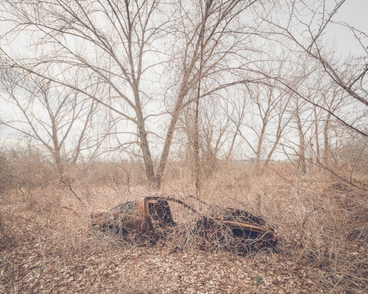
One of the park’s many abandoned cars.

An overturned vehicle marooned in a swamp east of Downey Pond.
Long before Staten Island’s industrial boom, the Lenape Indians camped here to take advantage of the nearby wetlands, where shellfish were plentiful. Remnants of the wetlands are still visible across Forest Avenue in Arlington Marsh, which is home to some of the last stretches of healthy salt marsh in New York City. Acquiring it was a major coup for the Parks Department, which plans to keep the 55 acres wild. Here, ghostly remnants of long-forgotten piers and burned out vessels seem oddly in sync with the tidal rhythms of the natural world. At low tide, a boat graveyard comes to the surface in an adjacent cove, where native cordgrass and mussel beds take root in the old hulls of 19th century sailing ships.
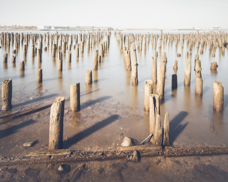
An expanse of pilings that once supported massive factory docks.
Oyster beds in the hull of a long-abandoned ship.
Fragment of a sailboat at Arlington Marsh.
This post would’ve ended there if I hadn’t come upon a mention of the 1976 murder of Susan Jacobson in connection with the area. Though the scene of the crime is never referred to as Mariner’s Marsh, the description is unmistakable in a New York Times article published in 2011, which begins:
“The 16-year-old boy had settled on a plan on how to kill his girlfriend. There was a blighted section on the north shore of Staten Island called Port Ivory, overgrown coastline facing the industrial banks of New Jersey. The land was pocked with holes leading to small underground rooms, like bunkers.
This abandoned lot was the last thing a 14-year-old girl named Susan Jacobson ever saw as she climbed down into one of those holes with her boyfriend, Dempsey Hawkins, on May 15, 1976. “
Ruins of a system of rails that closely match a description of the murder site.
Included in the article is a scan of a handwritten letter from Hawkins to the reporter in which he details an idyllic romance with Jacobson that ends abruptly following an abortion. In the final paragraph, he goes on, “In came 1976 and the insanity and the whole painful mess I am about to relate succinctly simply because it’s disturbing. I strangled Susan and concealed her body in a metal barrel in a wooded area across from a Proctor and Gamble factory on Staten Island.”
Two years passed before her remains were discovered by a boy playing in the tunnels. He had assumed they were dog bones until a friend spotted Susan’s tennis shoes. Hawkins, now 55, was denied parole for the eighth time in 2012 despite a history of good behavior behind bars. Parole commissioners have repeatedly taken issue with what occurred immediately after the crime. On multiple occasions, Hawkins himself participated in search parties for the missing girl, knowing all the while precisely where the body was hidden.
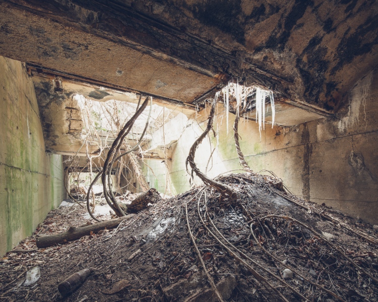
Icicles stretch into the darkness of the tunnel as vines spiral toward the light.
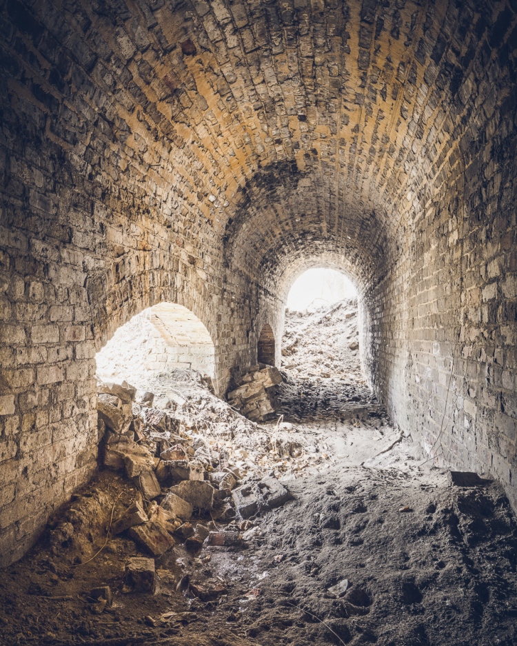
An arched passageway near the scene of the crime.
Book-Related Events Coming Up:
Brooklyn Brainery, April 15th 8:30-10:00, $7(Sold Out)- Dead Horse Bay, May 2nd, @ 12:45 I’ll be leading a walking tour of one of my favorite places in NYC with Untapped Cities
- Mid-Manhattan Library, May 7th, 6:30-8:00 PM, Free!
Last Days of the Staten Island Farm Colony
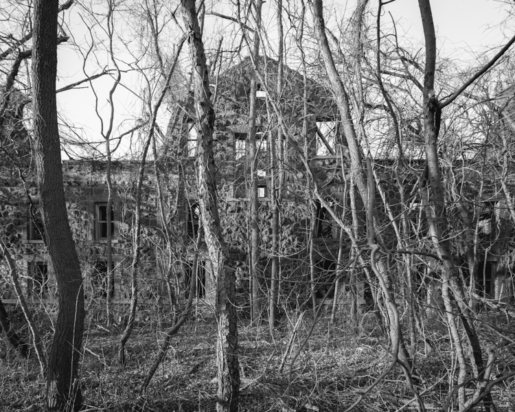
A ruined Farm Colony dormitory seen through the trees.
Part of what makes abandoned buildings so captivating is that their existence is ephemeral, they cannot remain decayed and crumbling forever, and inevitably that means saying goodbye.
Admittedly, the Staten Island Farm Colony is not one of the most spectacular places I’ve seen, (the interiors have been completely destroyed by vandalism) but it remains the one place I’ve come back to more than any other. What’s always impressed me about it is its changeability. The place is reborn with every season, and I suppose that’s true of all abandoned buildings, but I’m always struck by it at the Farm Colony. In the height of summer, its jungle-like atmosphere lends it the look of a fallen Aztec empire, which is almost unrecognizable in the cooler months. It’s haunting in the fall when the fog rolls in, and desolate in the winter when ice and snow blanket the buildings inside and out. Through 40 years of abandonment, the Farm Colony is as ever-changing as the natural world that engulfs it, but it’s looking more and more definite that this historic district will be undergoing a final, permanent transformation in the days ahead.
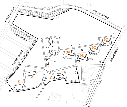
The Farm Colony’s existing structures.
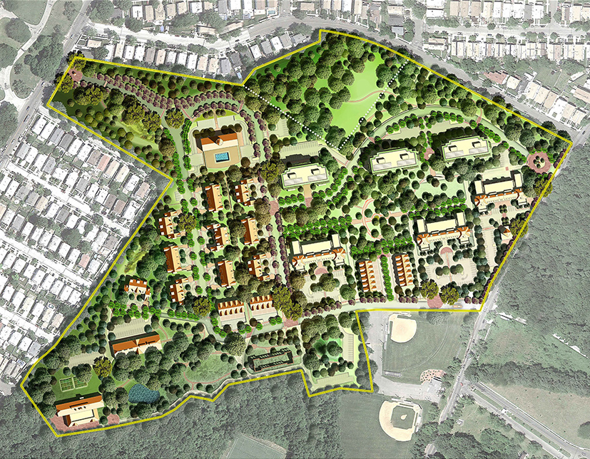
New renderings for the “Landmark Colony,” with several buildings preserved.
Last month, the Landmarks Preservation Commission unanimously approved a proposal to bring 350 units of senior housing to the site, part of a large new development called “The Landmark Colony.” In the process, the institution is returning to its historic function as a home for the elderly after a four decade hiatus. (The place was essentially a geriatric hospital when it closed down in the 1970s, though it had been established in the mid 19th century as a refuge for the poor.) With five buildings saved and one kept as a stabilized ruin, the design will preserve much of the area’s architectural character. The remaining structures will be demolished and replaced with modern residential units, which is to be expected considering just how far gone some of these buildings are.
Several of the places I’ve photographed in the last few years have been set aside for renovation (The Domino Sugar Refinery, the Gowanus Batcave, and P.S. 186 to name a few.) The Smith Infirmary, the old Machpelah Cemetery office, and most troublingly, the Harlem Renaissance Ballroom have not been so lucky. It’s rare and encouraging when a structure is fortunate enough to get a second chance in this rapidly evolving city, but as positive as these changes are for their communities, a part of me still feels like something is lost. I know I’m not the only one who’ll miss the Farm Colony and its embattled ruins, which have become a popular spot for paintballers and Staten Island teenagers to pass the time.
Here’s a series of photos I’ve taken over the last year in sweltering heat, biting cold, snow, rain, and fog. Hopefully I make it back one last time before these ancient grounds are covered with fresh paint and brimming with active retirees year-round.
The Laundry and Industrial building will be preserved…
…As will the Dining Hall. These are the two largest open spaces in the Farm Colony.
Daylight trickles into a dark room adjacent to the cafeteria.
An arched walkway on a lower floor is a rare example of architectural ornament.
The Farm Colony’s most picturesque building is sadly slated for demolition.
But a similar dormitory on the south side of the grounds will be stabilized and preserved as a ruin.
Snow piles up after winter storms, turning to ice when the temperature fluctuates.
A wintry bathroom.
This bed is one of the only remaining artifacts from the institution’s past.
Trees silhouetted against the clouds, projected through a camera obscura on the ground floor of a residence hall.
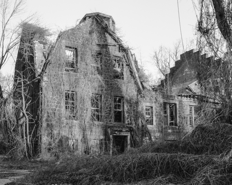
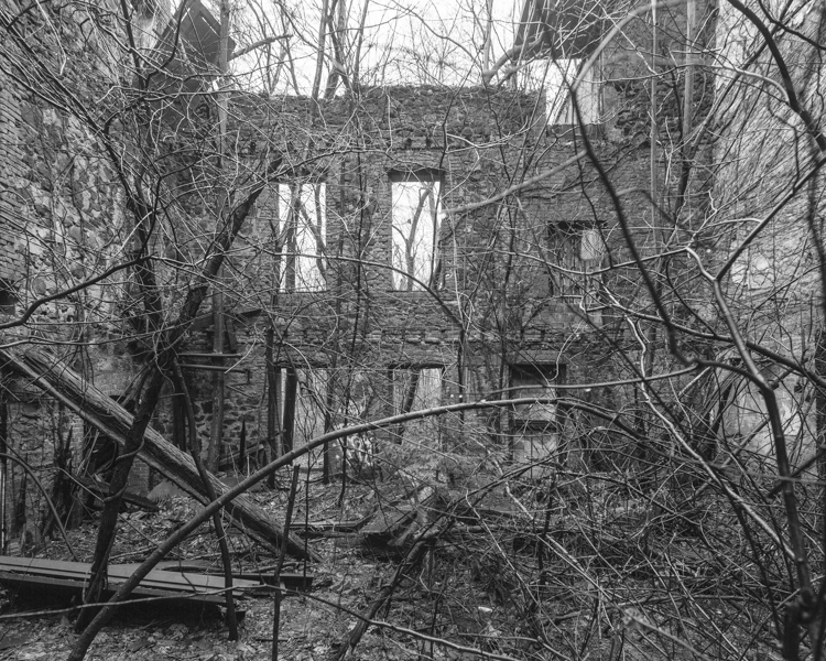
A Last Look Inside a Demolished Staten Island Castle

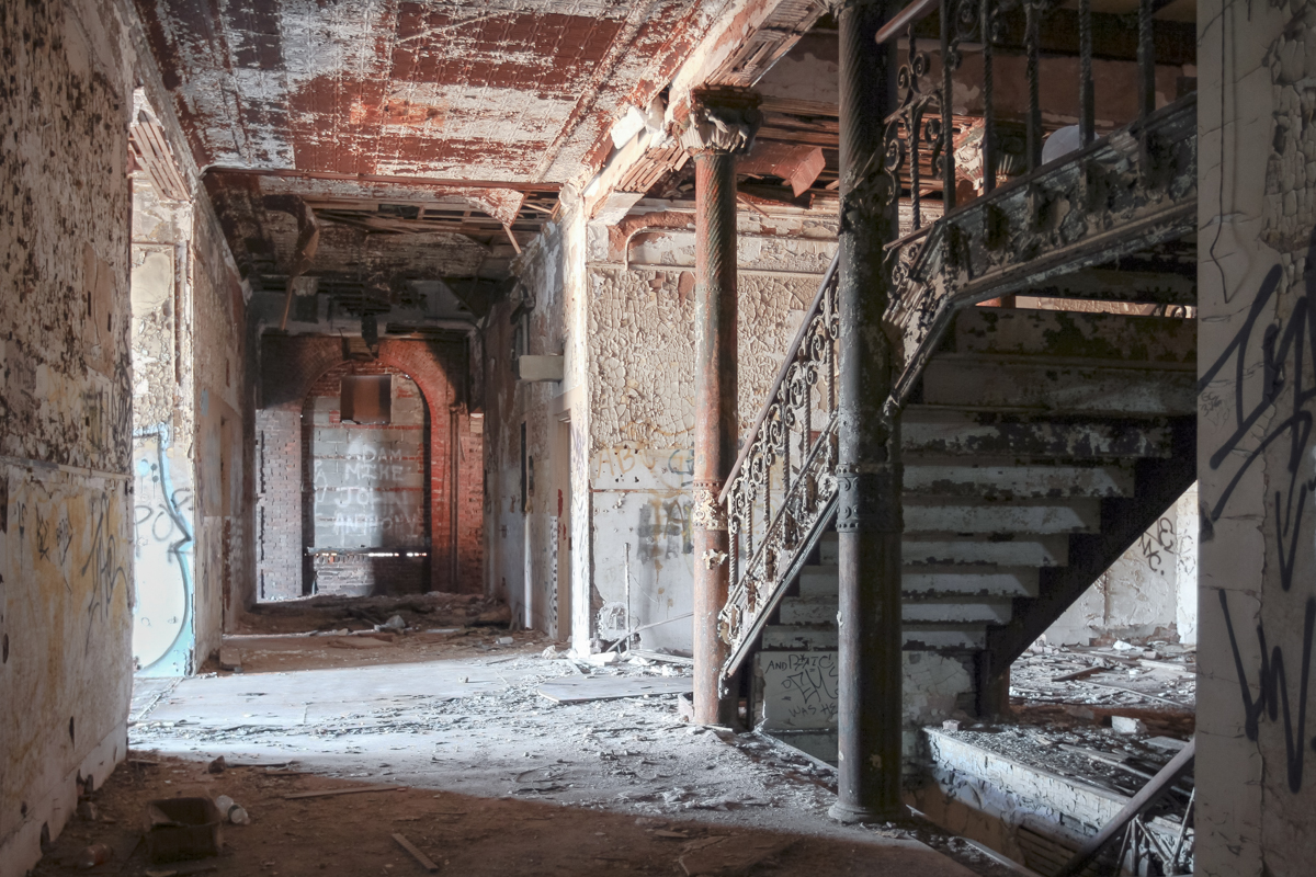
In its final years, the Frost Memorial Tower of the old Smith Infirmary looked like the quintessential haunted house.
For 124 years, a castle with many names loomed over the quiet neighborhood of Thompkinsville, Staten Island. Perched on a six-acre hilltop covered in creeping vines, the striking red brick chateau could have been the backdrop of a fairy tale until thirty years of neglect made it the perfect setting for a Gothic horror. On an early March morning in 2012 while most of the island slept, wrecking balls converged at the Frost Memorial Tower of the old Samuel R. Smith Infirmary. In a matter of hours, the hospital was brought to the ground. Dozens gathered to watch her fall.

The stately Infirmary in its youth.

In 2011, the weight of winter snow caused the roof of the building to cave in. The same year, Hurricane Irene caused further damage, dashing any hope of saving the structure.
Today, the rubble-strewn lot is a symbol of lost history and lost hope for members of the Preservation League of Staten Island and their supporters, whose passionate and repeated efforts to save the building did little to sway the resolve of the Landmarks Preservation Commission. City engineers who inspected the structure confirmed that the building was in a state of progressive collapse, and would have proven a hazard to firefighters entering the building in the event of a blaze.
Some elements were salvaged prior to demolition.
Named for a doctor who dedicated his life to the treatment of the poor, the Samuel R. Smith Infirmary was founded in 1863 as the borough’s first private hospital. Principally funded by lavish charity balls, the organization was the pet project of the borough’s high society, known as the “Pride of Staten Island.” By the turn of the twentieth century, the Infirmary had outgrown its former home, and the cornerstone was laid for a new building, named the Frost Memorial Tower in honor of the wealthy benefactor who had gifted the hilly plot of land. It was destined to become one of Staten Island’s stateliest buildings.
A band of sunlight illuminates a doorway to ghostly effect.
Though the Smith Infirmary was established for the poor, it soon opened its doors to the general public and was renamed Staten Island Hospital in 1916. Many notable actors, lawyers, and political figures were treated there, among more mysterious cases. In 1907, an Infirmary doctor was murdered by the husband of a former patient who had passed away during an operation. The damning evidence that led to the man’s execution is still visible in Cypress Hills Cemetery. On his wife’s grave is the following epitaph: “Revenge renews our happy love in heaven forever.”

This grand staircase was the interior’s most striking feature.
By 1974, the once-rural land surrounding the complex had become densely populated, leaving little room for expansion. At the time, one hundred patients were waiting daily for admission, and parking had become a serious problem. The campus was abandoned in 1979 when the hospital relocated to a new building on Seaview Avenue.
By the turn of the 21st century, the property had accrued millions of dollars in tax liens, falling into an irreversible state of disrepair.
In 1983, the Landmarks Preservation Commission declined to designate the Smith Infirmary’s signature building despite its architectural and historical significance. In what had become a rough neighborhood, the derelict hospital quickly gained a reputation for illicit activities, and landmark status was likely to hamper redevelopment. The land was targeted early on for a series of residential development schemes that never came to fruition. As the building deteriorated, the property became a hotbed of real estate fraud and a haven for the neighborhood homeless, but many held fond feelings for the structure—locals called it “the Castle.”

At the time the infirmary was built, corners were thought to harbor germs, so many hospital rooms were designed with circular walls.
Through 33 years of abandonment, the degraded walls, slumping ceilings, and precarious floors of the Infirmary were utterly devastated by the elements. The smell of mold and rot permeated the interior. Wind blustered through its second floor landing, causing boards and debris to smack and rattle at odd intervals. These were the dying breaths of a squandered architectural treasure. Rest in pieces, Staten Island Castle.
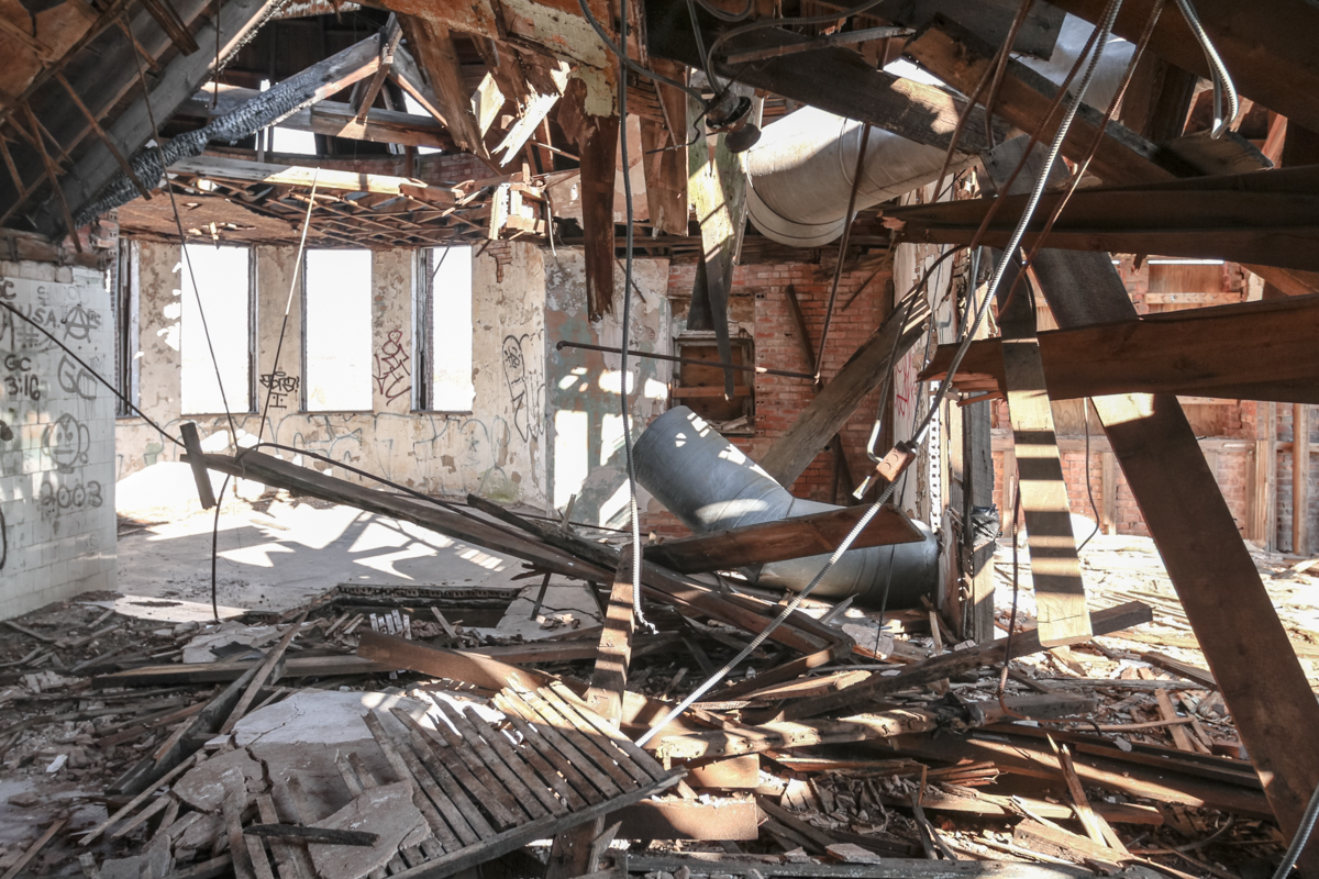
Where a ceiling had collapsed on the top floor, walls gave way to open sky amid a mass of broken beams.
Wandering Fort Wadsworth

Battery Weed looms over a desolate shoreline in Fort Wadsworth, Staten Island.
At the easternmost tip of Staten Island, a natural promontory thrusts over the seething Narrows of the New York Harbor, formed by glaciers thousands of years ago. The site’s geography most recently made it a prime location for the Verrazano Bridge, but its history as a popular scenic overlook and strategic defense post dates back to the birth of the nation. The British had occupied the area during the Revolutionary War, and its first permanent structures were built by the state of New York in the early 1800s. These fortifications safeguarded the New York Harbor during the War of 1812, but were abandoned shortly thereafter. So began the familiar cycle of ruin and rebirth that characterizes the history of Fort Wadsworth.
By the mid-19th century, these early structures had fallen into an attractive state of decay. In a time when all of Staten Island held a romantic appeal as an escape from the burgeoning industrialism of New York City, Fort Wadsworth in particular was known for its dramatic terrain, sweeping views of the harbor, and evocative old buildings. Herman Melville described the scene in 1839:
“…on the right hand side of the Narrows as you go out, the land is quite high; and on top of a fine cliff is a great castle or fort, all in ruins, and with trees growing round it… It was a beautiful place, as I remembered it, and very wonderful and romantic, too…On the side away from the water was a green grove of trees, very thick and shady and through this grove, in a sort of twilight you came to an arch in the wall of the fort…and all at once you came out into an open space in the middle of the castle. And there you would see cows grazing…and sheep clambering among the mossy ruins…Yes, the fort was a beautiful, quiet, and charming spot. I should like to build a little cottage in the middle of it, and live there all my life.”
Under the Verazzano Bridge.
The “castle” was demolished to make way for new fortifications constructed as part of the Third System of American coastal defense, known as Battery Weed and Fort Thompkins today. The batteries remain the fort’s most impressive and unifying structures, but they too were deemed obsolete as early as the 1870s due to advances in weaponry, and were used for little more than storage by the 1890s. At the turn of the 20th century, Fort Wadsworth entered yet another phase of military construction under the Endicott Board, when the United States made a nationwide effort to rethink and rebuild its antiquated coastal defenses. Like its predecessors, the Endicott batteries never saw combat, and were essentially abandoned after World War I.
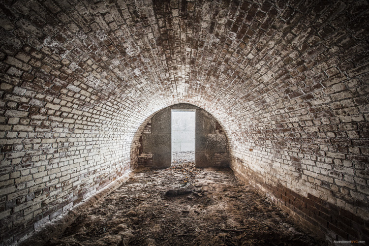
Inside a powder room of Battery Catlin.
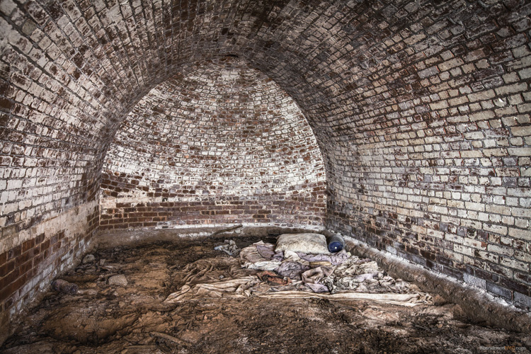
A squatter’s unmade bed in the back of the structure.
Though Fort Wadsworth was occupied by the military in various capacities until 1995, its defense structures went unused for most of the 20th century. By the 1980s, woods and invasive vines had covered areas that were once open fields, and Battery Weed was living up to its name, overtaken by mature trees and overgrowth. Since Fort Wadsworth was incorporated into the Gateway National Recreation Area in 1995, its major Third System forts (Battery Weed and Fort Thompkins) have been well maintained and properly secured, and upland housing and support buildings have been occupied by the Coast Guard, Army Reserve, and Park Police. But the headlands still retain an air of abandonment, due in large part to the condition of the Endicott Batteries, which remain off-limits to the public.
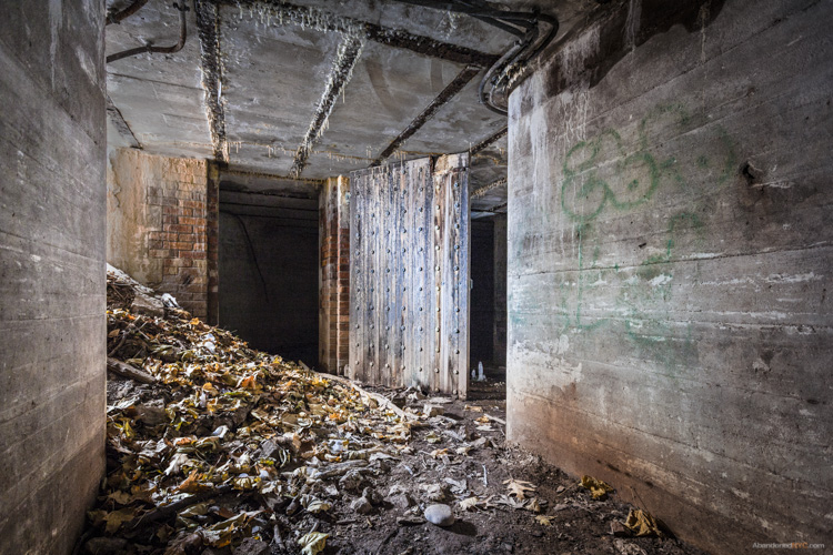
Over five of these batteries are scattered across the grounds, all in various states of disrepair.
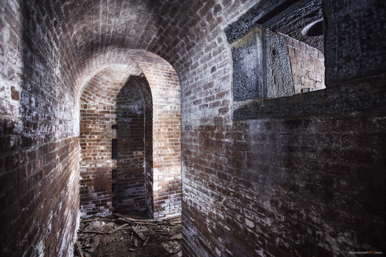
The Endicott Batteries are filled with narrow, windowless rooms, tomblike hollows, and underground shafts.
Their military blandness stands out in contrast to the grace and grandeur of the fort’s earlier structures deemed worthy of preservation.
Layers of history peel back like an onion at Fort Wadsworth, as evidenced by a new discovery just unearthed by Hurricane Sandy. The storm caused a section of a cliff to collapse, downing several large trees and exposing the entrance to a previously unknown battery. Its vaulted granite construction places it firmly in the Third System, which means it was built around the time of the Civil War. Very little is known about the structure, except that it’s the only one of its kind at Fort Wadsworth. My best guess traces its partial construction to the 1870s, when Congress left many casemated fortifications unfinished by refusing to grant additional funding.
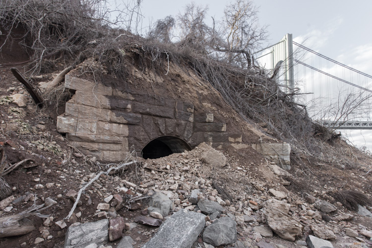
A previously unknown granite battery, possibly dating back to the Civil War, was unearthed by Hurricane Sandy.
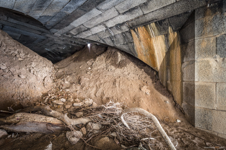
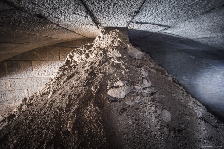
Large mounds of soil block the interior of the battery from view.
They’d been sifted through ventilation shafts in the ceiling over decades of burial.

Over the mound, the vaulted structure leads deeper into the ground.
To my disappointment, the next room came to a dead end, and to my horror, it was crawling with hundreds of cave crickets. These blind half spider/half cricket monstrosities pass their time in the darkest, dampest, most inhospitable environments, and are known for devouring their own legs when they’re hungry. They give perspective to the level of isolation of this chamber, which likely stood underground for over a century.
What other mysteries still lie buried in the lunging cliffs of Fort Wadsworth, or the depths of this forgotten battery? The dirt may well conceal deeper rooms and darker discoveries…
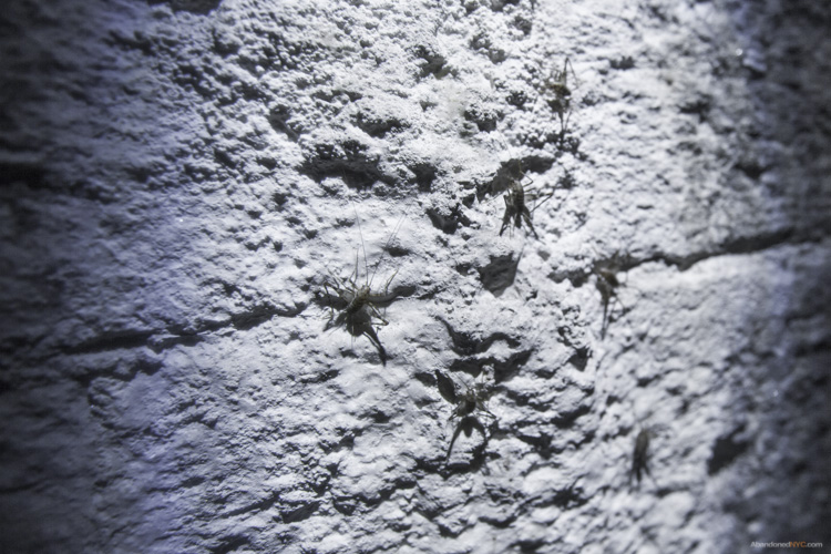
Cave crickets in the deepest room of the forgotten battery.
Special thanks to Johnnie for the tip! Get in touch if you know of a historic, abandoned, or mysterious location in the five boroughs that’s worth exploring.
Top Posts & Pages

