AbandonedNYC
Will Ellis
New Work for Dark Times – The Great Disaster

It’s been a while. I hope everyone out there is taking care, slowing down, and staying healthy. A lot has changed since I was actively exploring abandoned places in New York City. The Domino Sugar Refinery is now a popular park and mega-development, Harlem’s P.S. 186 is a charming apartment building, Creedmoor’s “Building 25” is… well, still a pigeon-infested nightmare factory as far as I know.
But now at the time of this writing, the city itself feels abandoned. It’s not hyperbole to say that New York will never be the same, because it’s never stayed the same. But exactly how this latest chapter will transform it remains to be seen, and we live with that uncertainty.
It’s left me, a non-essential architectural photographer, stuck at home in Brooklyn without the ability to work, but a sudden wealth of time to explore the sort of interests that led to the creation of this blog eight years ago. I’ve decided to share what I’ve been up to here. I think those of you who enjoy the darker side of history might appreciate it.

Many of us have taken comfort in apocalyptic novels and movies as a way of feeling more acutely the vague, omnipresent terrors of the moment. I’ve made my own contribution with The Great Disaster, using photo collage as a medium. Each of these images combine a dozen or more antique photographs, namely real photo postcards of the early 20th century, for which fires, floods, and local calamities were common subjects.

Real photo postcards were introduced by Kodak in 1903, allowing amateur photographers to print images directly onto pre-made postcard backs and share with far-flung friends and relatives. A century before Instagram, the notion proved irresistible and the format grew to dominate the photo industry. General stores across the country were stocked with postcards of local landmarks and events, and disasters were a major category.

Drawn to the eerie atmosphere of these early photographic artifacts, I collected over 150 examples. After digitizing the materials, I combined their most evocative subjects into the compositions you see here, presented in the style of their source material. The pictures chronicle the aftermath of a catastrophic fire in an unnamed American city, weaving together dozens of disparate, often unidentified events into a single narrative. Descriptive text is drawn from original hand-lettering found on the cards, incorporating headlines from the days after the Great Chicago Fire of 1871 and the 1906 San Francisco Earthquake.

Conceived as wildfires ravaged California and Australia and created from lockdown in New York City at the height of the COVID-19 pandemic, the series reflects on the human fascination with disasters at a time when these events take on unprecedented scale and regularity. While indulging in the curious appeal of catastrophe, the pictures illustrate the cyclic nature of any trauma, both the personal and collective, with their familiar rhythm of chaos, reflection, and renewal.

As part of this project, I’ve created a set of physical postcards which are available on my (other) website, with antique-style postcard backs. I’ll be donating half of the proceeds to Americares, a disaster relief organization working to respond to the pandemic.
Thanks for your support and stay safe out there.
-Will
![]()

Scouring the “South Pole” of New York

Rotted pilings beneath Outerbridge Crossing, with views of Perth Amboy, NJ.
From St. George, ride the Staten Island Railroad to the end of the line and you’re only a short walk from the southernmost point in New York State, at the mouth of the Arthur Kill. The name of the waterway stirs the imagination, but its Dutch origins are benign. Achter kill means back river or channel, in reference to its location at the “back” of Staten Island. Intriguingly, the route was carved out by an ancestral iteration of the Hudson River. Glacial activity altered the course to its current position, but the vestigial strait remained, isolating a sneaker-shaped land mass. Staten Island was born.

The Conference House
A stone’s throw from the so-called “south pole” of New York State, there’s an impressive bit of Revolutionary War history known as The Conference House. The name refers to a peace conference held there on September 11, 1776 between British commander Lord Howe and representatives of the Continental Congress, Benjamin Franklin and John Adams among them. Over the course of the three hour meeting, Howe urged the men to put aside their little rebellion. (They declined to do so.)
True to its contrarian nature even in revolutionary times, the borough was a loyalist stronghold, warmly greeting British troops upon their arrival. Hundreds of islanders enlisted in the British army as the conflict escalated. George Washington himself called the Staten Islanders “our most inveterate enemies.” John Adams was less generous, labeling them “an ignorant, cowardly pack of scoundrels, whose numbers are small, and their spirit less.”

Low tide in the Arthur Kill reveals the remains of wooden ships.

The borough is home to several lesser-known “boat graveyards” in addition to the famous Rossville salvage yard.
Tracing the Arthur Kill past the quaint historic houses of Tottenville, we enter into wilder territory and arrive at the base of Outerbridge Crossing, which spans the Arthur Kill between Charleston, SI and Perth Amboy, NJ. New Yorkers could be forgiven for assuming the name refers to its status as the most remote bridge in New York City, but it’s actually named for Eugenius Harvey Outerbridge, the first chairman of the Port Authority of New York and a resident of the borough. “Outerbridge Bridge” wouldn’t do, so they deemed it a “Crossing.”
Wandering these regions can be treacherous if you don’t plan ahead. As the tide ebbs and flows, open shoreline gives way to mud and water, leaving you with no way out but the head-high reeds of the marsh. In nesting season, geese are liable to attack (speaking from experience here). But for those willing to brave the wilderness, there are rewards. The fabric of the city dissolves on the outermost edges of Staten Island, and the ground is a layer cake of archaeological finds.

The remains of the Atlantic Terra Cotta Company factory line the shores of the Arthur Kill at the end of Ellis Street.
One area of interest at the foot of Ellis Street marks the site of The Atlantic Terra Cotta Company, which made colorful architectural ornaments for many notable city buildings, including the Flatiron and the Woolworth. It closed down in the 1940s and was demolished soon after, but much of the old factory is still there in the form of rubble. Enterprising beachcombers can still find Atlantic Terra Cotta tiles if they hunt long enough. (The old adage “leave no stone unturned” applies here, as many of the most intricate pieces are one-sided.) I managed to find a beautiful acorn-themed tile with an ATLANTIC stamp, but plain bricks were more readily available.
Many of them are inscribed with the names of long-gone manufacturers, resembling fragments of time-worn tombstones. Thanks to these markings and a devoted online community of brick collectors, it’s a simple matter to pinpoint their origins. The “RICHMOND” and “ATLANTIC” bricks were made in Staten Island, but others trace their ancestry to Brooklyn or New Jersey. Some are from much farther afield—“RELIANCE” Bricks hail from Texas; “MO REX” from a town called Mexico, Missouri. How all of them ended up here is a bit of a masonry mystery.

Manufacturer’s marks on the bricks point to a wide range of origins.
Just inland, marshes give way to roving woodlands that hold secrets of their own. If you look into any patch of untended forest, and many of the front yards, you’ll find a wealth of rusty relics of the one man’s treasure variety. While there isn’t much history to glean from them, they are fascinating to look at. A natural area known as Sharrot’s Shoreline was once filled with mountains of scrap metal and scores of abandoned cars. Only a few remain today after cleanup efforts by the city. What’s left is a serene nature reserve that would thrill most bird-watchers, though they might have a hard time finding a way in.
Nearby, a deserted graveyard of auto parts marked one of my most surprising finds to date. Chief among the relics was a group of corroded buses, apparently from the 1960’s. While the scene has an ancient air, the plot was the site of a multi-generational family business until quite recently, according to a neighbor who gave me a stern warning for trespassing on private property. (For that reason, I wouldn’t advise seeking them out for yourself.)
This has been the second installment of a series of posts on the edges of Staten Island. Next up, we’ll continue our trip down Arthur Kill Road, delving deeper into the history of Charleston and the “haunted” Kreischer Mansion. See more photos from the project here.

A foot of snow covers a “graveyard” of auto parts…

..pictured here in the fall.

Ghosts of Kreischerville

Kreischer Mansion
At Kreischer Street, Arthur Kill Road verges sharply right and branches into a tangle of dead-ends, hemmed in by woods and wetlands. The route winds into the heart of Charleston, Staten Island, a sensible industrial district given to sudden flights of fancy. Out here, stables and shooting ranges rub elbows with haunted mansions and sunken ships. It’s equal parts Wild West and Gothic Horror.
In this corner of the borough, street names and gravestones echo with the same few family names, but one name—Kreischer—rises above the rest. It’s written on the very building blocks of the oldest structures, etched into the walls of the local tavern and stamped into the sidewalks. Because the town was built of Kreisher bricks, by Kreischer bricks, and for Kreischer bricks. And before it was Charleston, it was Kreischerville.

The Kreischer Fire-Brick Works, pictured in the late 19th century.
Born in a small Bavarian village, Balthasar Kreischer emigrated to New York City in 1836, a year after a great fire destroyed much of Lower Manhattan. He quickly found employment rebuilding the burned district, taking a special interest in the construction of baker’s ovens. With a business partner he opened a brick works on the Lower East Side in 1845. His fire-proof bricks were made to withstand high temperatures in chimneys and furnaces, and required a specific type of raw material known as “fire clay.” Following the discovery of rich clay deposits in southwest Staten Island in the 1850s, he relocated his business to be close to the source.
The new location was a secluded section of the borough called Androvetteville, after a prominent local family. Balthasar bought up the clay pits and the waterfront on which to build his factory, and within a few decades the sleepy community of oystermen and mariners grew into an industrial boomtown, producing 20,000 bricks a day. As the brick works prospered, the neighborhood came to be known as Kreischerville.

A row of worker’s houses sits frozen in time on Kreischer Street


Kreischer took a paternalistic approach to leadership, providing housing for his workers and monetary aid during periods of sickness or financial distress. In return, he expected his employees to maintain appearances, keeping their yards and houses tidy for the benefit of all. Four of the original worker’s houses are still standing today, designated New York City landmarks in 1994. Some appear to be unoccupied, with rusted out cars from a bygone era parked in the driveway. The scene is startlingly out of step with the present, right down to the sidewalks. (They were paved with Kreischer bricks over a century ago.)
Kreischer retired in 1878, ceding control of the company to his three sons. Edward and Charles stayed in Staten Island and a third brother took the helm of the company’s headquarters in Manhattan. Shortly before his death in 1886, Balthasar gifted the town a new church edifice, which is still in existence, and commissioned a pair of mirror-image Victorian mansions on a hilltop overlooking the factory, intended as residences for Charles and Edward. Only Charles’ house remains today—a fire claimed Edward’s in the 1930s.

The church was a gift to the community from Balthasar before his death.
Edward himself met a tragic end in 1894, when he was found dead not far from the factory of a self-inflicted gunshot wound. Publicly, his brother George was at a loss for what had led to Edward’s decision. But friends of the deceased told a different story, pointing to friction between the two brothers. After Balthasar’s death, the business was divided equally between his five children, but Charles had moved quickly to acquire a controlling stake in the company by purchasing the interest of his two sisters.
Diminishing returns at Kreischer and Sons may have been another factor. The factory was sold in foreclosure in 1899 and closed in 1906. (Many workers found employment at the nearby Atlantic Terra Cotta Works, outlined in a previous post.) As time wore on, “Kreischerville” was renamed “Charleston” in response to anti-German sentiment during World War I. Nature gradually reclaimed the old clay quarries, transforming them into small ponds which became the namesake of Clay Pit Ponds State Park. Meanwhile, Kreischer House stood watch on Kreischer Hill, becoming a New York City landmark in 1968.

Only one Kreischer Mansion is extant today. Edward’s (on the left) was destroyed by fire.
As the building aged and a gulf of time distanced Edward’s untimely end, the house gradually ripened into the “haunted mansion” it was always destined to be. But it wasn’t until 2005 that its status was cemented into the public consciousness. That year, Kreischer Mansion gained notoriety as the setting of a real-life horror story—a gruesome mob murder perpetrated by none other than the house’s caretaker.
The man was paid $8000 to carry out a Sopranos-style hit of a Bannano crime family associate who’d run afoul of the group. The New York Times reported the grisly details in 2006: “The victim was lured to a secluded landmark, a Victorian mansion on a hilltop on Staten Island, but he proved hard to kill. When an effort to strangle him failed, he was stabbed, then dragged to a nearby pond and drowned. His body was dismembered with hacksaws and incinerated in the mansion’s furnace.”
The drowning actually occurred not in a pond, but in a small reflecting pool in front of the mansion, lined with yellow Kreischer bricks.

Kreischer Mansion
Unaware of the incident, the estate’s owner moved forward with renovations that were already underway at the time of the murder. By the time the F.B.I. got wind of the killing and moved to search the mansion for evidence, the furnace had been replaced. The Ohio-based developer had planned to build a community for the elderly called “Kreischerville” with the mansion as its centerpiece. But the plans were scrapped in 2012 and the property was put on the market for $11.5 million, with the house accounting for $1.6 million of the overall value. The 5-acre property is currently back on the market for $12 million.
For now, the house sits empty as ghost stories swirl around it, concentrating on Edward’s grieving widow, despite the fact that she never actually lived in the house. There are signs that the mansion is starting to embrace its reputation. In 2015, it opened its doors on Halloween night for an interactive theater piece. Last year, the house closed out the first season of a ghost hunting show called “Paranormal Lockdown”. The claims are dubious, but ultimately harmless. After all, a sordid history is a remembered history. Kreischer Mansion may stand for another hundred years, or longer, as one of Staten Island’s most compelling links to its 19th century past.

End of Androvette Street
Approaching the “Forgotten Borough”

Seagulls follow in the wake of the Staten Island Ferry.
Hello friends, its been a while. I’ve been on a bit of a hiatus from poking around abandoned buildings, but I’m back now with something a little different. This is the first installment of a series on Staten Island—an area of the city that tends to go unnoticed, but is very much worth exploring.
For the unfamiliar, Staten Island stands with Manhattan, Brooklyn, the Bronx, and Queens as one of the five boroughs that make up the city of New York. It is the third largest and least populated of the five. Its identity has always been somewhat distinct from the city at large, due in part to its geographical isolation. Prior to the construction of the Verrazano Bridge in 1964, no crossing existed between Staten Island and any other borough. It remains something of an outlier today, with a suburban nature and right-leaning political tilt. A record of neglect from city government has earned it the oft-repeated title “the forgotten borough,” and the name has stuck.

The Staten Island Ferry departs from Lower Manhattan.
From a Manhattan-centric point of view, a trip to Staten Island begins with a ride on the Staten Island Ferry. Over 21 million passengers embark on the 25-minute journey from Lower Manhattan to St. George each year. With dramatic views of the Statue of Liberty and the surrounding harbor, it’s a well-known attraction for New York City tourists. The ride is offered free of charge by the city’s Department of Transportation, but that hasn’t always been the case.
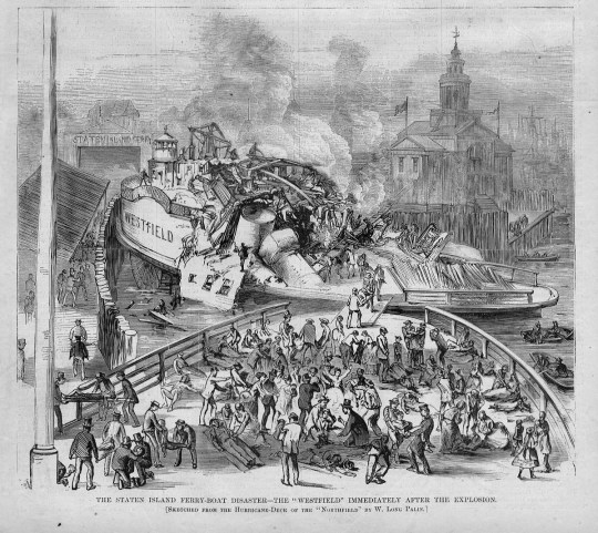
An engraving of the 1871 “Westfield” disaster.
Back in the 18th century, sailboats manned by private individuals competed for fares between Manhattan and Staten Island. In 1817, the first mechanically powered ferry service went into operation, under the direction of Captain John de Forest of the Richmond Turnpike Company. His brother-in-law Cornelius Vanderbilt took over in 1838. Existing ferry service proved inadequate as Staten Island developed, and accidents were common.
In 1871, a boiler explosion on one of the ferries claimed the lives of more than 85 passengers. Jacob Vanderbilt, the president of the Staten Island Railway at the time, was charged with murder, but never convicted. In 1901, a ferry operated by the Staten Island Rapid Transit Company collided with a Jersey Central ferry and sank into the harbor soon after departing the port at Whitehall. Though the disaster was far less deadly than the 1871 episode, city authorities used it as justification to seize control of the service by 1905.

The iconic orange color of the ferries was adopted in 1926, to increase their visibility in heavy fog and snow.
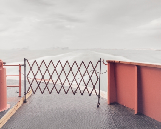
Leaving Manhattan.
A nickel fare was the rule through most of the 20th century, but was increased in 1975 to a quarter, and in 1990 to 50 cents, causing an uproar among borough residents. Coupled with mounting grievances over the Fresh Kills Landfill on the island’s west shore, the fare hike gave rise to a secession movement, which culminated in the passage of a non-binding referendum to make Staten Island an independent city in 1993.
Efforts to secede were subdued by the election of Mayor Rudy Guiliani, who rode to power due in part to overwhelming support from Staten Island voters, many of whom had been won over by his promises to close the landfill and do away with the fare. He followed through on both, abolishing the fare in 1997 and closing the landfill in 2001.

The Verrazano Bridge was the longest suspension bridge in the world at the time it was built.
While the ferry has played a significant role in the history of Staten Island, the construction of the Verrazano-Narrows Bridge has arguably had the greatest impact on its development. The story of Staten Island can generally be understood in terms of two epochs—before and after November 21, 1964, the day the bridge first opened to traffic.
Long-time residents speak longingly of Staten Island before the bridge—when country roads meandered through sweeping forests, quiet beach communities, and open expanses of farmland crawling with nanny goats. In the 19th century, full-time islanders lived side by side with some of the city’s wealthiest residents. As the industrialized city minted new millionaires, many of them looked to the rolling green hills of Staten Island as a scenic escape.
The nature of the borough was permanently altered as the Verrazano-Narrows Bridge prompted a mass migration of newcomers from overpopulated Brooklyn. The influx covered farms and forests with mile upon mile of tract housing, plaguing the island with traffic problems that persist to this day.

The official name of the Verrazano-Narrows Bridge includes a misspelling of its namesake, Florentine explorer Giovanni da Verrazzano.
As much as the borough has transformed over the years, it has retained its essential otherness. Crossing the harbor by ferry or bridge signals a psychological detachment from the urban environment of New York as we know it. In the hum of traffic, or the roar of surf, the city melts away and you enter a new frontier. Beyond and in-between the strip malls and cookie-cutter houses, scattered remnants of an older, more pastoral Staten Island await. There, Times Square feels a million miles away.
Over a series of upcoming posts, I’ll be examining the many artifacts and oddities that litter the far-flung edges of the borough, and sharing the history behind them. In the meantime, you can visit my website to see more photos from the project, “Arthur Kill Road.”

View of Staten Island obscured by fog, from Bay Ridge, Brooklyn.

An early morning at Fort Wadsworth, on the opposite side of the span.

Navigating the Sailor’s Infirmary

The Sailor’s Infirmary
In 1831, “An Act to Provide for Sick and Disabled Seamen” was passed by the New York State Legislature. A tract of farmland was acquired for the purpose, and by 1837, a proper hospital was constructed, funded by a head-tax imposed on sailors entering the Port of New York. The intention was admirable and the structure was impressive. Looking at the distinctively 19th-century facade of the old Sailor’s Infirmary today, it’s easy to imagine the place brimming with leathery old salts in their twilight years, regaling each other with adventures at sea that’d put Herman Melville to shame.
In those days, the porticos of the Infirmary offered commanding views of the New York Harbor and the surrounding countryside. In 1862, the Infirmary’s Chief Physician rhapsodized on the subject: “the weary invalid can breathe the bracing air of the sea…the sight of his chosen element, covered with the white winged messengers of a world-wide commerce that fills his mind with hope and cheer.”
Today, its pastoral surroundings have been swallowed up by development, the “white-winged messengers” have vanished from the harbor, and the halls of the hospital no longer resound with tales of youthful exploits in the exotic port cities of the world. Instead, a fire alarm near the front door blares interminably, to nobody at all.

The hospital as it appeared in 1887.

Expansive porches provided views of the harbor to ailing seamen.
While the idea of a hospital for sailors might seem odd to the modern observer, there was an urgent need for this sort of specialized care in the 19th century, when sailing was a much more common occupation and working conditions were deplorable. The Infirmary’s first Chief Physician described the health of a newly admitted patient in 1838 as such: “Arrived last night on brig from round Cape Horn…Has been to sea 118 days and had nothing but indifferent salt food to feed upon…Twenty days after sailing his gums became sore and spongy and bled very freely…Around the small of each leg caked hard and over the instep a deep blue almost black color…Suffered universal pain…Very much prostrated and emaciated and was brought into the (Infirmary)…Had no lime juice on board nor any other antiscorbutic effectual in preventing scurvy…It is in this shameful manner vessels are provided to the destruction of seamen…An object of pity to behold.”
In addition to advocating for better living and working conditions for seamen, the Sailor’s Infirmary made a lasting impact on world health as the birthplace of one of the most formidable biomedical research facilities in the world. In 1887, a young doctor founded a one-room bacteriological laboratory in the attic of the hospital to investigate epidemics like cholera and yellow fever. Over the course of the 20th century, his humble “Laboratory of Hygiene” evolved into a federally-funded research initiative that still operates today with an annual budget of $30 billion. Needless to say, it outgrew the attic long ago.

Researchers at work in the attic’s “Laboratory of Hygiene” (1887)
The attic as it appears today. The area was renovated in 1912.
Over the course of the 20th century the infirmary greatly expanded its services, and the campus grew to include a seven-story hospital and multiple ancillary buildings, dwarfing the original structure in the process. Under federal ownership, the grounds served military families, veterans, and later the general public. An organization of the Catholic medical system took over in 1981, and the hospital’s focus pivoted to psychiatric care and addiction rehabilitation. In recent years, the campus has been racked with financial problems, and its services have been consolidated to a few floors of the main hospital building. The rest of the complex sits abandoned, facing an uncertain future despite multiple landmark designations.
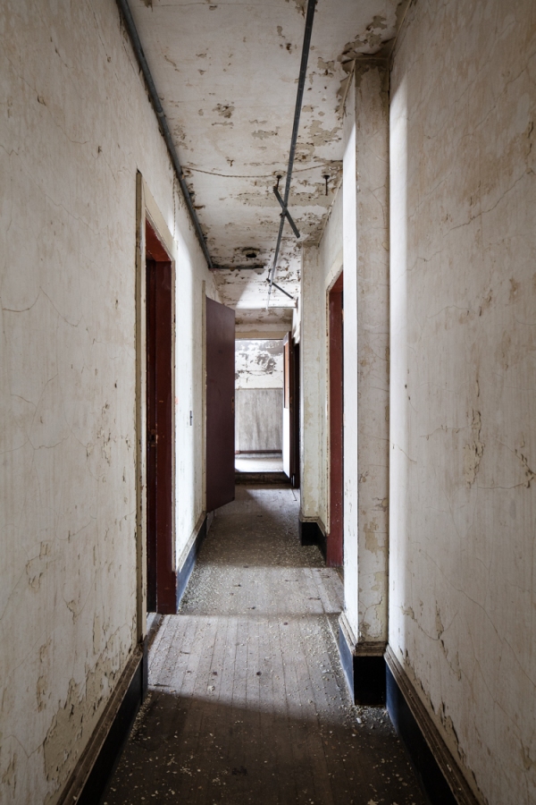
Like many grand, old buildings, the 1837 Infirmary appears to have been shut down from the top down. Dental clinics and early childhood programs lingered into the early 2000s on the lower floors, while the top floor sat unused for decades. Today, the interior is largely empty and plain—drop ceilings and fluorescent lights abound. But the attic retains a much older patina, and a few odd relics that feel fantastically out of step with the modern trappings below.
(Note: This is one of those rare abandoned buildings that isn’t vandalized beyond all recognition. In the hopes of keeping it that way I’ve chosen not to disclose its actual name and location, or to identify some key elements of its history.)

Teddy bear wallpaper and faux stained glass in an area used as a preschool.

Old hand painted lettering exposed under layers of chipped paint.

I’m not sure what the artist was going for here. Abstract rendering of a barn?

A bit of ornamentation was still visible on the stairs.

Upstairs in the attic, a fascinating pedal-operated sewing machine.

Mouldering files in the south wing.

Solid wood wardrobes were far older than furniture on the lower floors.

A red door led into a utility room.

Storage spaces in the attic held a number of intriguing artifacts.

Including a set of 1940s dental chairs.
In other news… I’ve got a new website that just went live. Head over to www.willellisphoto.com for a look at some of my other photo projects, plus a sampling of the work I do for a living (shooting non-abandoned architecture and interiors.) You can also sign up for my newsletter if you’re so inclined, or buy a book. (They’re 10% OFF with the code “ANYC.”)

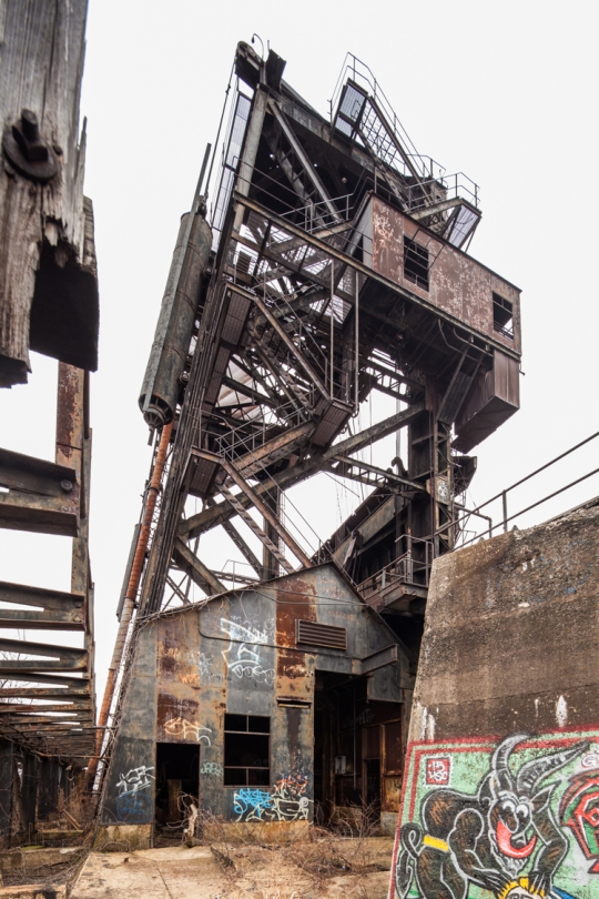
Port Reading’s McMyler Coal Dumper

The abandoned McMyler Coal Dumper in Port Reading, NJ
There’s a stretch of the Arthur Kill between Rossville, Staten Island and Port Reading, New Jersey that’s something of an abandoned wonderland. From the New Jersey side, the horizon is dominated by the twin natural gas tanks of Chemical Lane, and the famous Staten Island Boat Graveyard is plainly visible just across the water. But towering over the scene is a structure that rivals both with its staggering beauty and power—the McMyler Coal Dumper.
Actually, it would be more accurate to call it a McMyler Coal Dumper. It was one of many nearly identical structures built on the shores of the New York Harbor in the early-to-mid 20th century, including two on Pier 18 in Jersey City. But the Port Reading site is notable for being the last one standing in the New York area. It was constructed in 1917, making it 99 years old at the time of this post.
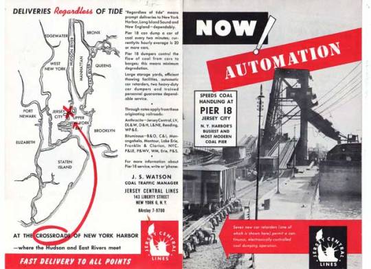
A 1957 ad for Pier 18 in Jersey City, which boasted two “Big Mac” McMyler Dumpers.
In a vast regional network of coal mines, breakers, railroads, and manufacturing hubs, these machines provided a vital link that helped fuel New York’s industrial age, transferring massive amounts of coal brought by rail from Pennsylvania and the Alleghenies into ships entering the harbor. A McMyler Dumper could unload a 72-ton car of coal every two and a half minutes, operating on a continuous loop for maximum efficiency.
Upon entering the pier, railroad “hoppers” carrying a full load of coal would be pushed up a ramp with a mechanism called a barney. Once in position at the base of the tower, the entire car and its contents would be lifted up on an unloading platform and tilted at 120 degrees, spilling the coal into an enormous “pan,” which funneled the material through an unloader chute and into the holds of outgoing barges. Once empty, the car would be lowered and pushed onto a kickback trestle by the next car in the line-up. These rails looked very much like a roller coaster, and they worked in a similar fashion, using the power of gravity to propel empty cars off of the pier and into the rail yards beyond. The contraption required twelve men to operate, and the work was risky. The brute force of the machine claimed many lives and limbs over the years.
A braver soul would have climbed the tower, but I was satisfied with the view from the pier.
The design stood the test of time, and the pier operated for over 60 years with nearly uninterrupted use (a fire caused considerable damage in 1951, but the unloader was quickly rebuilt.) With demand for coal declining, the machine dumped its last load in the early 80s, and has been steadily deteriorating ever since. Though there has been interest in designating the structure an historic site, its location on private property in an active industrial area has made it an unlikely candidate, and the cost of restoring or moving the structure would be prohibitive, to put it mildly. Unless new industrial development threatens the site, it will likely remain a picturesque ruin for another century before eventually collapsing into the Kill and vanishing into the muck.
That is lucky for the throng of Canada Geese who’ve made a surreal home out of the hulking relic. Though they’re nice to look at, I’ve never had a pleasant encounter with these creatures, and have been charged at by enough of them on the remote shores of the outer boroughs to know they mean business. This time around they were content to squawk and hiss their disapproval from a distance, but I would advise everyone to stay far away during nesting season, which is right around the corner.
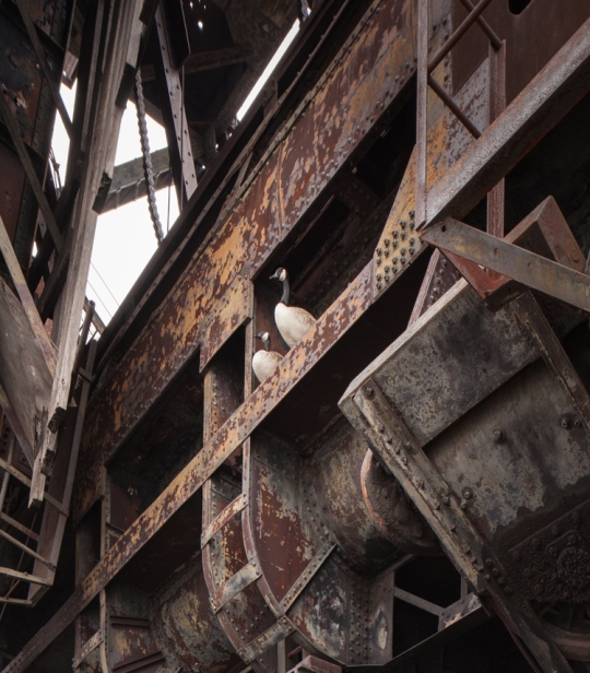
The self-appointed guardians of the coal dumper.

A pair of steam engines inside the machine room powered a cable drum…

…which controlled the “barney,” a mechanism used to push cars onto the unloading platform.
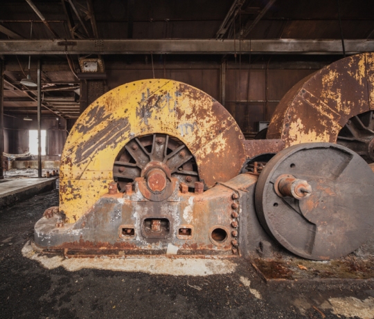
These cable drums raised and lowered the unloading platform. Much of the machinery has been removed by scrappers over the years.

The place has a fair amount of graffiti, some quite old. Kaleen’s protestation on the upper right was particularly endearing.

A derelict ferry boat sinks into the Kill on an adjacent pier.
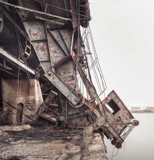
The pan and chute, pictured here, were left in an upright position until Hurricane Irene sent them crashing onto the pier below in 2011. An operator would have sat in the little chamber on the right. A pair of abandoned gas tanks in Rossville, Staten Island can be seen on the horizon.

Low Tide at the McMyler Coal Dumper.
You can see (a model of) a McMyler Coal Dumper in action in the following video:
Time Traveling in the Children’s Ward: Rockland Psychiatric Center

Pink walls distinguish the girl’s ward of the former Rockland State Hospital children’s building.
Old buildings have many lives. Often the objects left behind in a modern ruin only reflect a place’s most recent iteration. But in Rockland County, one structure exists as a veritable nesting doll of time periods. Today, some areas of the abandoned Children’s Hospital at Rockland Psychiatric Center are unsettlingly modern, looking like a tornado swept through a present-day kindergarten classroom. But stepping from one room to the next can take you back another 10, 20, 30 years…

A coffee mug seems out of place in this heavily decayed section of the hospital.
The squat, maze-like ward was constructed in 1929 to house the youngest subset of Rockland State Hospital’s population. (The history of the institution and its notable bowling alley were outlined in a previous post.) Though it hasn’t been used to house mentally ill children since the 1960s and 70s, it continued to serve the needs of kids and families in recent decades. Beginning in the 1980s it was used as a day care center for children of RPC employees called “Kid’s Corner.” In 1998, sections of the building were used for a program called “Under the Weather,” which provided free care to moderately sick kids, enabling their parents to get back to work while their children recuperated. These valuable programs were abruptly closed by the Department of Mental Health in 2008 for budgetary reasons.

This section of the building was last used in the early 2000s as a day care center.

A Peanuts mural from the 90s or early 00s would have been in poor taste several decades earlier.
All of these developments can be traced through the hospital’s extensive collection of murals. They vary greatly in quality and subject matter, but all represent a concerted effort by founders and staff to brighten up the institutional halls over the years. The finest of them is a series of thoughtfully designed and obviously professional works depicting scenes from the tales of Washington Irving. These and a similar set depicting the four seasons were painted in the 1940s by the Works Progress Administration muralist Victor Pedrotti Trent. Much of the work is well-preserved, but some areas have suffered irreparable water damage. Years ago a study estimated that moving and restoring the paintings would cost $100,000, a prohibitive figure. Since then, there’s been little interest in preserving them.

In one section of the mural depicting classic stories by Washington Irving, Rip Van Winkle awakes from a long slumber.
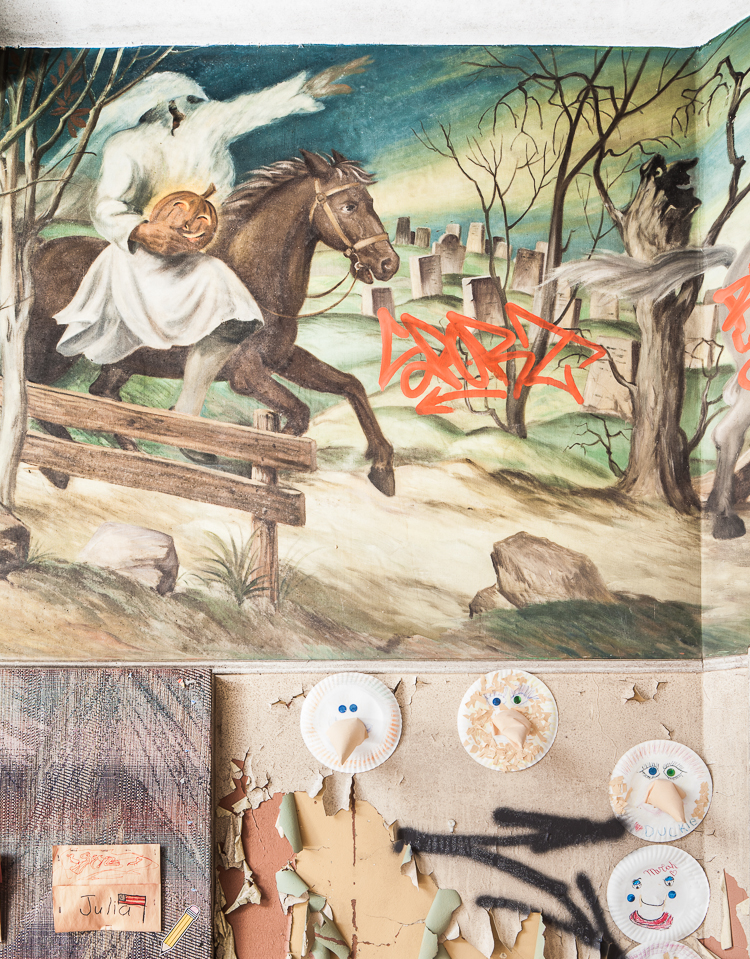
Ichabod Crane flees from the Headless Horseman in this scene from “Sleepy Hollow.” Note the creepy face in the hollowed out tree.

Some sections of the mural are heavily damaged by water and temperature fluctuations.
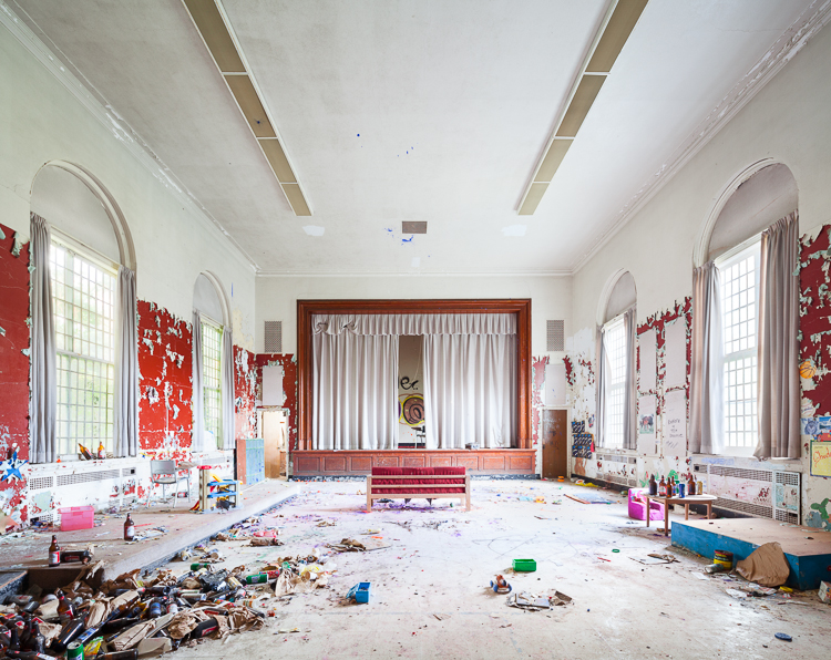
Through the painted vestibule, beer bottle middens pile up in a relatively plain auditorium.
The building is the oldest of several structures on the campus that catered to children with psychiatric disorders. A modern children’s center is still in operation at Rockland Psych, and another built in the 1960s is currently being leased as a filming location for the hit Netflix show “Orange is the New Black,” standing in for the women’s prison depicted in the series. The 1929 hospital was slated for demolition years ago, but that doesn’t appear to be happening any time soon.
Though much of the building is crowded with modern-day kid stuff, some wings of the structure–namely the former boy’s ward–appear to have been walled off during the 80s and 90s. Those halls are largely empty, and the few artifacts left behind are far older and institutional in nature. I wonder if the youngsters at Kid’s Corner realized there was a children’s asylum ward preserved like a mosquito in amber just on the other side of their playroom…
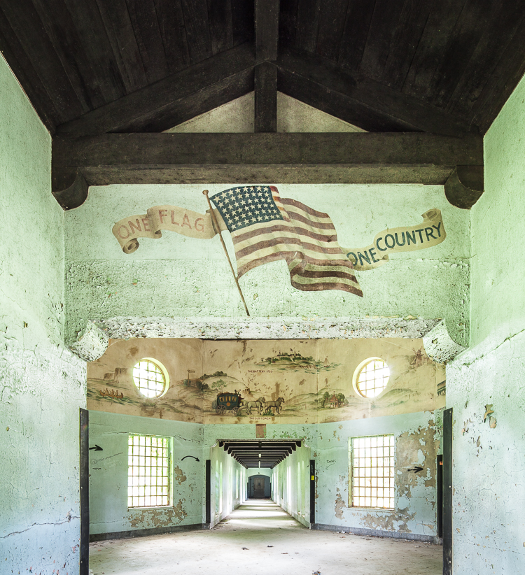
A mural with patriotic themes characterizes the boy’s wing of the structure.

Though not as impressive as the Trent murals, it offers a charming timeline of the development of New York City…

…beginning with the voyage of The Half Moon, a Dutch East India Company vessel.

A few relics from the state hospital era lie scattered around the halls, likely moved here for an urbex photo op.
Paper stars wither like autumn leaves over a doorway in the former boy’s ward.
IN OTHER NEWS… I’ve had a few spots open up on a tour of Dead Horse Bay I’ll be leading this weekend. It will take place Sunday, November 8th and we’ll be meeting at 10AM. It’s short notice, but I’d be happy to have a few more folks join in! Tickets available at this link.

ALSO… I’m excited to announce Abandoned NYC just went into its second printing! Thanks to all who helped me reach this milestone by ordering a book, showing up to events, and supporting the blog. To those who haven’t gotten their hands on a copy, get your signed first edition while supplies last!
Inside Rockland Psychiatric Center

An abandoned section of the former Rockland State Hospital, now known as Rockland Psychiatric Center.
In 1923, the New York state legislature passed a $50 million bond issue for the construction of new mental hospitals. After a disastrous fire at Ward’s Island in 1924, “where scores of mentally afflicted…were burned to death,” $11 million was set aside for a new campus designed specifically to relieve overcrowding at institutions in New York City. The town of Orangeburg, NY was chosen for its proximity to the five boroughs, picturesque surroundings, and “salubrious climate.”

The hospital once housed 9,000 people, including patients and staff.
With funding in place, the construction of the Rockland State Hospital for the Insane moved forward at a staggering pace. Townspeople looked on as the monstrous institution swallowed up tract after tract of farms, houses, and undeveloped land. As patients flooded into the new buildings by the thousands, escapes became a regular occurrence. The “potential menace” of this “new and formidable population of undesirable outsiders” was a cause of great concern for locals. Infrequent but grisly murders in the vicinity of the hospital were attributed to “mentally disturbed” escapees. But the real horrors were occurring on the inside, as many of Orangeburg’s citizens could personally attest to–the institution was one of the largest job providers in the county.

Chipped plaster, masonry, paint, and wallpaper fill a water basin.
The real trouble started during World War II, when lucrative war industry jobs lured much of the staff away and a large number of Rockland’s male attendants left to join the armed forces. As the population soared to nearly 9,000, patient-to-staff ratios plummeted. “The work is hard, disagreeable and frequently dangerous, and the hospital has found it next to impossible to recruit employees.” New hires during this period were often untrained and unqualified. From a 1940s Times article: “An employment bureau in New York City sent a number of applicants here, but most of them were found to be suffering from arthritis, cardiac ailments or “unnatural” temperament and had to be sent home. ‘Some of them should be patients,’ Dr. Blaisdell said.”

A stash of nudie magazines hidden long ago in the basement of a kitchen area.
Like most all institutions operating during this period, the overcrowding and lack of effective treatment led to systemic abuse and negligence. Until the development of antipsychotic drugs in the 1960s, shock therapy and lobotomy were the only treatment methods available for severe cases of schizophrenia and other mental illnesses. As the century progressed and the new drugs became readily available, most patients were able to live independently outside of the asylum system. Since the 1970s, Rockland Psychiatric Center (as it is now known) has predominantly been used as an outpatient facility. By 1999 it housed less than 600 patients. Several new facilities were constructed in more recent years for outpatient care, but vast expanses of the 600 acre campus are entirely empty.

Mattresses piled up in a dayroom.
Today, a grid of overgrown streets divides a vast configuration of maze-like buildings known only by number. These were separate wards for men, women, children, and other subsets of the population like the infirm, the violent, and the criminally insane. Others were workshops, auditoriums, power plants, administration buildings, staff housing… the list goes on and on.
Exploring the buildings can be confusing and perilous. One ward’s heavy wooden doors had the nasty habit of slamming shut and refusing to open again, which can be a serious situation when there’s only one or two ways out. My solution was a series of improvised doorstops–beer cans, scraps of debris, whatever I could get my hands on–which doubled as a trail of breadcrumbs to give me a reasonable hope of finding my way out again.
One of Rockland’s most interesting features is the old four lane bowling alley. It’s a heavily trafficked area full of tempting props. Pins, balls, shoes, and trophies have been endlessly moved around, manipulated, and arranged into perfect triangles in the middle of the lanes. While I don’t blame fellow photographers for this sort of thing, it can be disappointing to walk into something that looks more like a stage set than a wild, unpredictable ruin. I’ll take that over the mindless graffiti–some if which I removed with a little Photoshop magic in the images below.
Despite all the modern mischief making, the bowling alley represents the best intentions of the institution to provide quality of life to patients who spent their lives at Rockland. These lanes must have been a welcome distraction from the monotony of asylum living.
Stay tuned for an upcoming post on the Rockland Children’s Hospital, which features an impressive collection of WPA murals.

A well-preserved bowling alley was located on the ground floor of a recreation building.

Blank score sheets could be found behind the ball return.

The AMF bowling equipment may date back to the 60s or 70s.

Bowling balls pile up at the end of the lanes from previous visitors.

Compared to the bowling balls, the pins were scarce. Many had been stolen over the years.

Wood shelving used for bowling shoes, once arranged by size.

Trophies for male and female bowlers.
A Wintry Return to the St. Nicholas Coal Breaker

The St. Nicholas Coal Breaker, mid-demolition
The Pennsylvania coal region was once dominated by 300 breakers–mammoth factories that crushed and cleaned raw coal into the consumable commodity that fueled the Industrial Revolution. Today, a few modern plants meet the drastically reduced demand for the stuff. Of the old glory days when coal was king, only St. Nicholas remains.
The structure once held the distinction of being the largest coal breaker in the world, and its sheer size must have played a part in staving off the wrecking ball for the last 50 years. But according to the president of Reading Anthracite, the building’s owner, the place has become an “eyesore and a liability,” and its total demolition is imminent. A state-funded study to determine the cost of transforming the ruins into a historical attraction came up with a figure in the tens of millions.

With exterior walls removed, skeletal views of the plant’s interior come to light.
The demolition won’t happen in one cataclysmic, cathartic crash. Rather, the breaker is being dismantled piece by piece, and mined for valuable scrap metal along the way. The process is expected to last into next year, having been underway since Fall 2014. With a bit more of it gone every day, visitation has picked up as folks have poured into the region for one last look. Security positioned outside aim to ensure they respect the No Trespassing signs.
I took my “one last look” in February on a day that was way too cold to spend in an abandoned factory. Much of the metal siding had already been removed, opening up dollhouse views of the interior. Inside, light poured into corners that had been pitch black before. Elsewhere, panoramas of the surrounding landscape spread wall to wall and floor to ceiling.
After 50 years of abandonment, the old St. Nicholas Coal Breaker still inspires awe and commands respect. The interior of the breaker is noticeably free of graffiti. Visitors have stuck to more temporary means of commemorating their presence, tracing initials in the grime of a dusty control panel or chalking them up on a blackboard, avoiding outright acts of vandalism out of reverence for the building. It’s impressive not only for its physical size and beauty of design, but for the time and place in American history that it represents, a coal industry that employed 180,000 workers and enabled a young country to rise to the forefront of the industrialized nations. As St. Nick falls, little remains to tether that heritage to the here and now.

Otherworldly views of the frozen coal fields outside the breaker.

Coal dust mingles with snow drifts where the structure is open to the elements.

Names scrawled in a dusty control panel.

A control room in the upper reaches of the breaker.

Empty shelves in a maintenance room.

Enormous wooden molds for replacement parts littered this floor.

Construction vehicles stalled in the snow, seen through an upper floor of the breaker.

The conveyor, where raw coal began its journey through the breaker’s machinery.

Machinery salvaged from the breaker prior to demolition.
For more history on the St. Nicholas Coal Breaker, see the original post:

The St. Nicholas Coal Breaker, pictured in April 2014.
Join Me on a Tour of Dead Horse Bay!

“Bottle Beach” at Dead Horse Bay, Brooklyn.
What’s Dead Horse Bay?
Beginning in the 1850s, this area of the Brooklyn waterfront served as the final destination for the city’s carriage horses. Horse carcasses were delivered by barge to gigantic bone boiling plants and processed into glue and fertilizer. Following the rise of the automobile and a series of natural disasters, the factories closed down and fell to ruin. What was then a marshy landmass called “Barren Island” was filled in with garbage and connected to mainland Brooklyn. The southern tip of the new peninsula was used as an active landfill from the 1930s to the early 50s.
Over the last 60 years, the man-made beach at Dead Horse Bay has slowly eroded away, and decades’ worth of trash have been gradually excavated from the soil. At low tide, garbage covers the beach, and the vast majority of it dates back to the 1930s and 40s. There’s a preponderance of glass, not plastic, bottles. Some bear the faded trademark of long-lost brand names. Tellingly, most of the toys and trinkets were “Made in the U.S.A.” Others originated in “Occupied Japan.”
The beach is open to the public as part of the Gateway National Recreation Area, and I know that many of you are adventurous enough to visit on your own. But if you’d prefer a slightly more structured group activity, this tour won’t disappoint.

Some familiar brand names among the old bottles.
What are the transport/parking options getting to the event?
Dead Horse Bay is remote and easy to miss, so we’ll be meeting at a predetermined location in Flatbush that’s easily accessible by subway and taking the bus over together. You’ll recieve an email with detailed meeting instructions beforehand. The tour itself will take around two hours, but you can expect to be back at the meeting point 3 hours from the start time. If you prefer to drive, free parking is available in Floyd Bennett Field, just across the street from the beach.
What can I expect from the tour?
After a short bus ride to the waterfront, we’ll be making a loop through Dead Horse Bay’s natural areas, covering the entire shoreline affected by the breached landfill. Along the way, I’ll give you an account of the rise and fall of Barren Island’s industrial age, including the plight of the factory workers, the efforts of the “Anti-Barren Island League,” and the story of how the island became infested with 1,000 wild hogs. Then you’re free to explore on your own before we reconvene for an informal “show and tell” where we’ll show off our favorite finds from the day. More info and ticketing available here.
Is it OK to take things from the beach?
While a few might bristle at the thought of removing “artifacts” from Dead Horse Bay, there is no official word on the issue. A steady stream of artists, crafters, and collectors have been gathering supplies and curios here for years, without much of a reduction in the overall amount of garbage. Generally, I don’t have a problem with removing things from the beach (I’m certainly guilty of it.) But since we’ll be visiting as a group, I do want to minimize our impact as much as possible. I won’t stand in your way if you’d like to take home a bottle or two, but the best policy might be to leave things behind for others to enjoy.
Here’s a few of the best finds I’ve made over the past few years: (Click to enlarge)


Top Posts & Pages

