AbandonedNYC
Historic
Scouring the “South Pole” of New York
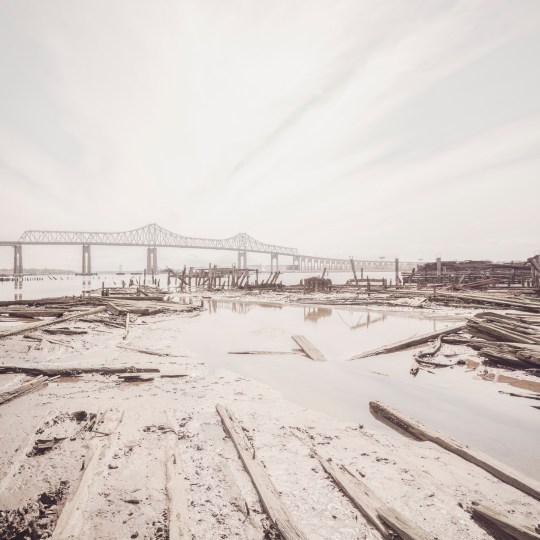
Rotted pilings beneath Outerbridge Crossing, with views of Perth Amboy, NJ.
From St. George, ride the Staten Island Railroad to the end of the line and you’re only a short walk from the southernmost point in New York State, at the mouth of the Arthur Kill. The name of the waterway stirs the imagination, but its Dutch origins are benign. Achter kill means back river or channel, in reference to its location at the “back” of Staten Island. Intriguingly, the route was carved out by an ancestral iteration of the Hudson River. Glacial activity altered the course to its current position, but the vestigial strait remained, isolating a sneaker-shaped land mass. Staten Island was born.
The Conference House
A stone’s throw from the so-called “south pole” of New York State, there’s an impressive bit of Revolutionary War history known as The Conference House. The name refers to a peace conference held there on September 11, 1776 between British commander Lord Howe and representatives of the Continental Congress, Benjamin Franklin and John Adams among them. Over the course of the three hour meeting, Howe urged the men to put aside their little rebellion. (They declined to do so.)
True to its contrarian nature even in revolutionary times, the borough was a loyalist stronghold, warmly greeting British troops upon their arrival. Hundreds of islanders enlisted in the British army as the conflict escalated. George Washington himself called the Staten Islanders “our most inveterate enemies.” John Adams was less generous, labeling them “an ignorant, cowardly pack of scoundrels, whose numbers are small, and their spirit less.”
Low tide in the Arthur Kill reveals the remains of wooden ships.

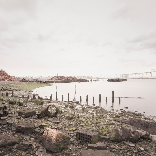
The borough is home to several lesser-known “boat graveyards” in addition to the famous Rossville salvage yard.
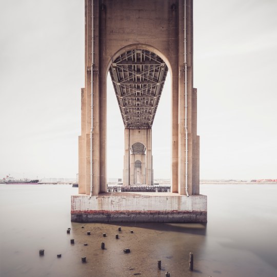
Tracing the Arthur Kill past the quaint historic houses of Tottenville, we enter into wilder territory and arrive at the base of Outerbridge Crossing, which spans the Arthur Kill between Charleston, SI and Perth Amboy, NJ. New Yorkers could be forgiven for assuming the name refers to its status as the most remote bridge in New York City, but it’s actually named for Eugenius Harvey Outerbridge, the first chairman of the Port Authority of New York and a resident of the borough. “Outerbridge Bridge” wouldn’t do, so they deemed it a “Crossing.”
Wandering these regions can be treacherous if you don’t plan ahead. As the tide ebbs and flows, open shoreline gives way to mud and water, leaving you with no way out but the head-high reeds of the marsh. In nesting season, geese are liable to attack (speaking from experience here). But for those willing to brave the wilderness, there are rewards. The fabric of the city dissolves on the outermost edges of Staten Island, and the ground is a layer cake of archaeological finds.
The remains of the Atlantic Terra Cotta Company factory line the shores of the Arthur Kill at the end of Ellis Street.
One area of interest at the foot of Ellis Street marks the site of The Atlantic Terra Cotta Company, which made colorful architectural ornaments for many notable city buildings, including the Flatiron and the Woolworth. It closed down in the 1940s and was demolished soon after, but much of the old factory is still there in the form of rubble. Enterprising beachcombers can still find Atlantic Terra Cotta tiles if they hunt long enough. (The old adage “leave no stone unturned” applies here, as many of the most intricate pieces are one-sided.) I managed to find a beautiful acorn-themed tile with an ATLANTIC stamp, but plain bricks were more readily available.
Many of them are inscribed with the names of long-gone manufacturers, resembling fragments of time-worn tombstones. Thanks to these markings and a devoted online community of brick collectors, it’s a simple matter to pinpoint their origins. The “RICHMOND” and “ATLANTIC” bricks were made in Staten Island, but others trace their ancestry to Brooklyn or New Jersey. Some are from much farther afield—“RELIANCE” Bricks hail from Texas; “MO REX” from a town called Mexico, Missouri. How all of them ended up here is a bit of a masonry mystery.
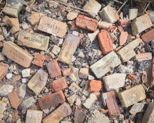
Manufacturer’s marks on the bricks point to a wide range of origins.
Just inland, marshes give way to roving woodlands that hold secrets of their own. If you look into any patch of untended forest, and many of the front yards, you’ll find a wealth of rusty relics of the one man’s treasure variety. While there isn’t much history to glean from them, they are fascinating to look at. A natural area known as Sharrot’s Shoreline was once filled with mountains of scrap metal and scores of abandoned cars. Only a few remain today after cleanup efforts by the city. What’s left is a serene nature reserve that would thrill most bird-watchers, though they might have a hard time finding a way in.
Nearby, a deserted graveyard of auto parts marked one of my most surprising finds to date. Chief among the relics was a group of corroded buses, apparently from the 1960’s. While the scene has an ancient air, the plot was the site of a multi-generational family business until quite recently, according to a neighbor who gave me a stern warning for trespassing on private property. (For that reason, I wouldn’t advise seeking them out for yourself.)
This has been the second installment of a series of posts on the edges of Staten Island. Next up, we’ll continue our trip down Arthur Kill Road, delving deeper into the history of Charleston and the “haunted” Kreischer Mansion. See more photos from the project here.
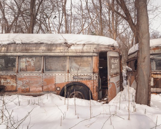
A foot of snow covers a “graveyard” of auto parts…
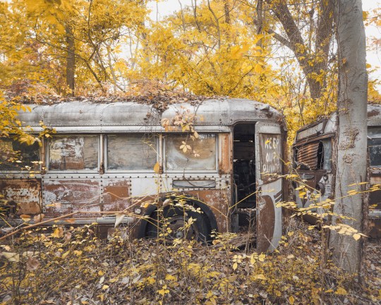
..pictured here in the fall.
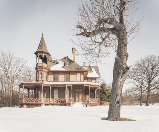
Ghosts of Kreischerville

Kreischer Mansion
At Kreischer Street, Arthur Kill Road verges sharply right and branches into a tangle of dead-ends, hemmed in by woods and wetlands. The route winds into the heart of Charleston, Staten Island, a sensible industrial district given to sudden flights of fancy. Out here, stables and shooting ranges rub elbows with haunted mansions and sunken ships. It’s equal parts Wild West and Gothic Horror.
In this corner of the borough, street names and gravestones echo with the same few family names, but one name—Kreischer—rises above the rest. It’s written on the very building blocks of the oldest structures, etched into the walls of the local tavern and stamped into the sidewalks. Because the town was built of Kreisher bricks, by Kreischer bricks, and for Kreischer bricks. And before it was Charleston, it was Kreischerville.
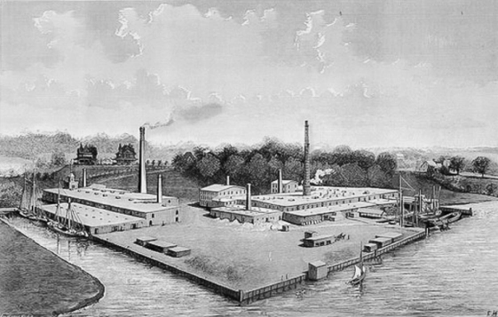
The Kreischer Fire-Brick Works, pictured in the late 19th century.
Born in a small Bavarian village, Balthasar Kreischer emigrated to New York City in 1836, a year after a great fire destroyed much of Lower Manhattan. He quickly found employment rebuilding the burned district, taking a special interest in the construction of baker’s ovens. With a business partner he opened a brick works on the Lower East Side in 1845. His fire-proof bricks were made to withstand high temperatures in chimneys and furnaces, and required a specific type of raw material known as “fire clay.” Following the discovery of rich clay deposits in southwest Staten Island in the 1850s, he relocated his business to be close to the source.
The new location was a secluded section of the borough called Androvetteville, after a prominent local family. Balthasar bought up the clay pits and the waterfront on which to build his factory, and within a few decades the sleepy community of oystermen and mariners grew into an industrial boomtown, producing 20,000 bricks a day. As the brick works prospered, the neighborhood came to be known as Kreischerville.
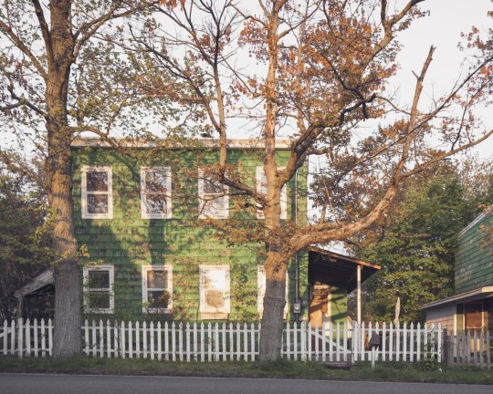
A row of worker’s houses sits frozen in time on Kreischer Street


Kreischer took a paternalistic approach to leadership, providing housing for his workers and monetary aid during periods of sickness or financial distress. In return, he expected his employees to maintain appearances, keeping their yards and houses tidy for the benefit of all. Four of the original worker’s houses are still standing today, designated New York City landmarks in 1994. Some appear to be unoccupied, with rusted out cars from a bygone era parked in the driveway. The scene is startlingly out of step with the present, right down to the sidewalks. (They were paved with Kreischer bricks over a century ago.)
Kreischer retired in 1878, ceding control of the company to his three sons. Edward and Charles stayed in Staten Island and a third brother took the helm of the company’s headquarters in Manhattan. Shortly before his death in 1886, Balthasar gifted the town a new church edifice, which is still in existence, and commissioned a pair of mirror-image Victorian mansions on a hilltop overlooking the factory, intended as residences for Charles and Edward. Only Charles’ house remains today—a fire claimed Edward’s in the 1930s.
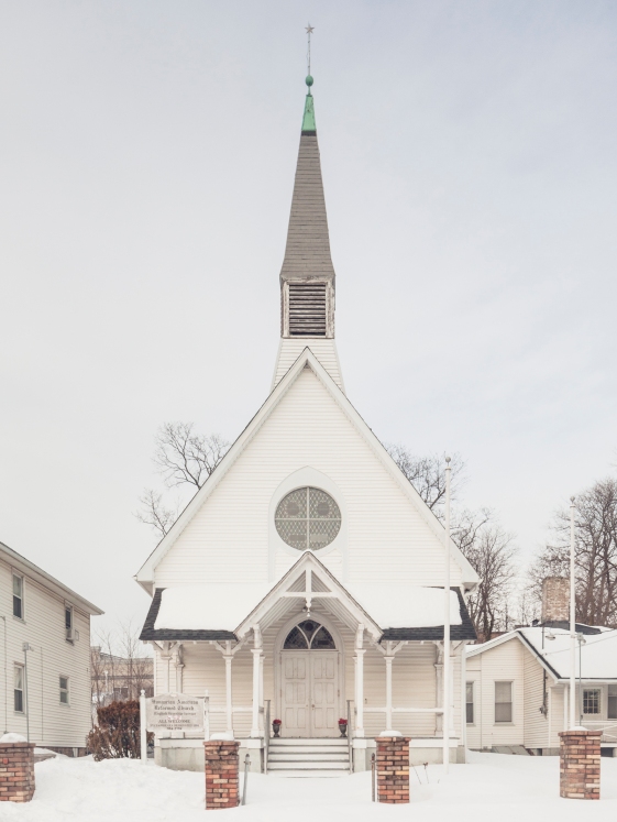
The church was a gift to the community from Balthasar before his death.
Edward himself met a tragic end in 1894, when he was found dead not far from the factory of a self-inflicted gunshot wound. Publicly, his brother George was at a loss for what had led to Edward’s decision. But friends of the deceased told a different story, pointing to friction between the two brothers. After Balthasar’s death, the business was divided equally between his five children, but Charles had moved quickly to acquire a controlling stake in the company by purchasing the interest of his two sisters.
Diminishing returns at Kreischer and Sons may have been another factor. The factory was sold in foreclosure in 1899 and closed in 1906. (Many workers found employment at the nearby Atlantic Terra Cotta Works, outlined in a previous post.) As time wore on, “Kreischerville” was renamed “Charleston” in response to anti-German sentiment during World War I. Nature gradually reclaimed the old clay quarries, transforming them into small ponds which became the namesake of Clay Pit Ponds State Park. Meanwhile, Kreischer House stood watch on Kreischer Hill, becoming a New York City landmark in 1968.
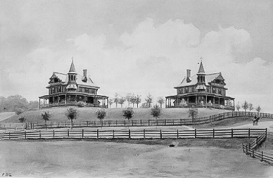
Only one Kreischer Mansion is extant today. Edward’s (on the left) was destroyed by fire.
As the building aged and a gulf of time distanced Edward’s untimely end, the house gradually ripened into the “haunted mansion” it was always destined to be. But it wasn’t until 2005 that its status was cemented into the public consciousness. That year, Kreischer Mansion gained notoriety as the setting of a real-life horror story—a gruesome mob murder perpetrated by none other than the house’s caretaker.
The man was paid $8000 to carry out a Sopranos-style hit of a Bannano crime family associate who’d run afoul of the group. The New York Times reported the grisly details in 2006: “The victim was lured to a secluded landmark, a Victorian mansion on a hilltop on Staten Island, but he proved hard to kill. When an effort to strangle him failed, he was stabbed, then dragged to a nearby pond and drowned. His body was dismembered with hacksaws and incinerated in the mansion’s furnace.”
The drowning actually occurred not in a pond, but in a small reflecting pool in front of the mansion, lined with yellow Kreischer bricks.
Kreischer Mansion
Unaware of the incident, the estate’s owner moved forward with renovations that were already underway at the time of the murder. By the time the F.B.I. got wind of the killing and moved to search the mansion for evidence, the furnace had been replaced. The Ohio-based developer had planned to build a community for the elderly called “Kreischerville” with the mansion as its centerpiece. But the plans were scrapped in 2012 and the property was put on the market for $11.5 million, with the house accounting for $1.6 million of the overall value. The 5-acre property is currently back on the market for $12 million.
For now, the house sits empty as ghost stories swirl around it, concentrating on Edward’s grieving widow, despite the fact that she never actually lived in the house. There are signs that the mansion is starting to embrace its reputation. In 2015, it opened its doors on Halloween night for an interactive theater piece. Last year, the house closed out the first season of a ghost hunting show called “Paranormal Lockdown”. The claims are dubious, but ultimately harmless. After all, a sordid history is a remembered history. Kreischer Mansion may stand for another hundred years, or longer, as one of Staten Island’s most compelling links to its 19th century past.
End of Androvette Street
Approaching the “Forgotten Borough”
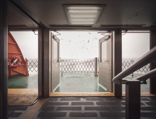
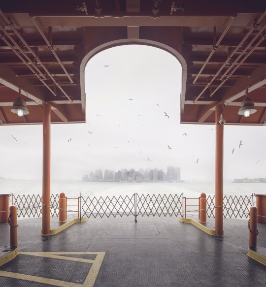
Seagulls follow in the wake of the Staten Island Ferry.
Hello friends, its been a while. I’ve been on a bit of a hiatus from poking around abandoned buildings, but I’m back now with something a little different. This is the first installment of a series on Staten Island—an area of the city that tends to go unnoticed, but is very much worth exploring.
For the unfamiliar, Staten Island stands with Manhattan, Brooklyn, the Bronx, and Queens as one of the five boroughs that make up the city of New York. It is the third largest and least populated of the five. Its identity has always been somewhat distinct from the city at large, due in part to its geographical isolation. Prior to the construction of the Verrazano Bridge in 1964, no crossing existed between Staten Island and any other borough. It remains something of an outlier today, with a suburban nature and right-leaning political tilt. A record of neglect from city government has earned it the oft-repeated title “the forgotten borough,” and the name has stuck.
The Staten Island Ferry departs from Lower Manhattan.
From a Manhattan-centric point of view, a trip to Staten Island begins with a ride on the Staten Island Ferry. Over 21 million passengers embark on the 25-minute journey from Lower Manhattan to St. George each year. With dramatic views of the Statue of Liberty and the surrounding harbor, it’s a well-known attraction for New York City tourists. The ride is offered free of charge by the city’s Department of Transportation, but that hasn’t always been the case.

An engraving of the 1871 “Westfield” disaster.
Back in the 18th century, sailboats manned by private individuals competed for fares between Manhattan and Staten Island. In 1817, the first mechanically powered ferry service went into operation, under the direction of Captain John de Forest of the Richmond Turnpike Company. His brother-in-law Cornelius Vanderbilt took over in 1838. Existing ferry service proved inadequate as Staten Island developed, and accidents were common.
In 1871, a boiler explosion on one of the ferries claimed the lives of more than 85 passengers. Jacob Vanderbilt, the president of the Staten Island Railway at the time, was charged with murder, but never convicted. In 1901, a ferry operated by the Staten Island Rapid Transit Company collided with a Jersey Central ferry and sank into the harbor soon after departing the port at Whitehall. Though the disaster was far less deadly than the 1871 episode, city authorities used it as justification to seize control of the service by 1905.
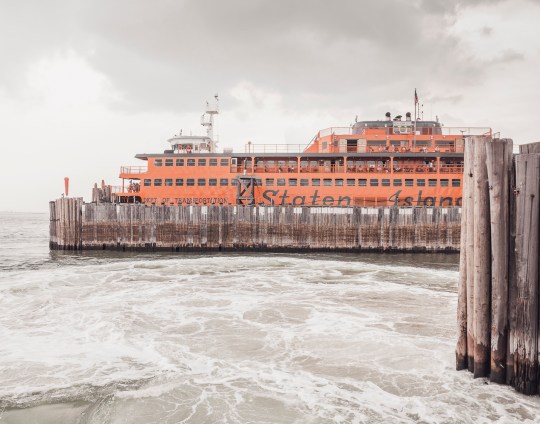
The iconic orange color of the ferries was adopted in 1926, to increase their visibility in heavy fog and snow.
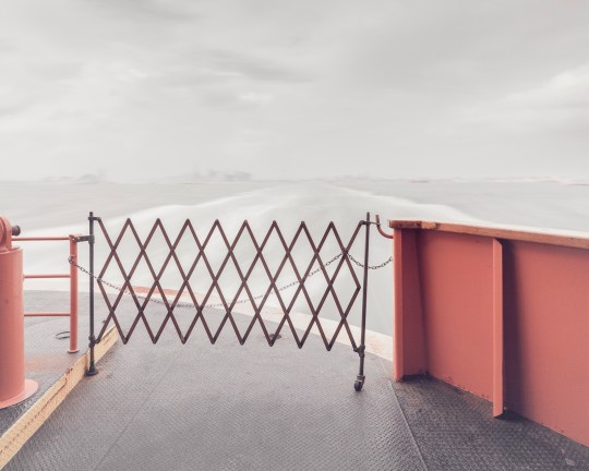
Leaving Manhattan.
A nickel fare was the rule through most of the 20th century, but was increased in 1975 to a quarter, and in 1990 to 50 cents, causing an uproar among borough residents. Coupled with mounting grievances over the Fresh Kills Landfill on the island’s west shore, the fare hike gave rise to a secession movement, which culminated in the passage of a non-binding referendum to make Staten Island an independent city in 1993.
Efforts to secede were subdued by the election of Mayor Rudy Guiliani, who rode to power due in part to overwhelming support from Staten Island voters, many of whom had been won over by his promises to close the landfill and do away with the fare. He followed through on both, abolishing the fare in 1997 and closing the landfill in 2001.
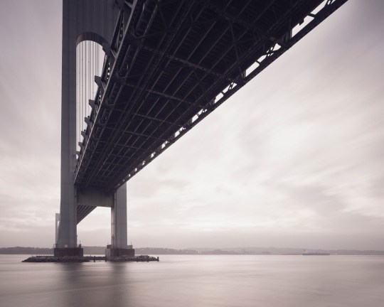
The Verrazano Bridge was the longest suspension bridge in the world at the time it was built.
While the ferry has played a significant role in the history of Staten Island, the construction of the Verrazano-Narrows Bridge has arguably had the greatest impact on its development. The story of Staten Island can generally be understood in terms of two epochs—before and after November 21, 1964, the day the bridge first opened to traffic.
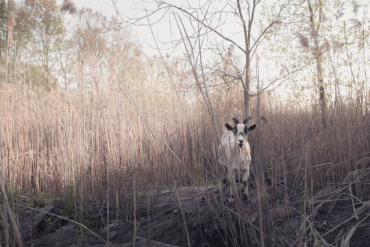
Long-time residents speak longingly of Staten Island before the bridge—when country roads meandered through sweeping forests, quiet beach communities, and open expanses of farmland crawling with nanny goats. In the 19th century, full-time islanders lived side by side with some of the city’s wealthiest residents. As the industrialized city minted new millionaires, many of them looked to the rolling green hills of Staten Island as a scenic escape.
The nature of the borough was permanently altered as the Verrazano-Narrows Bridge prompted a mass migration of newcomers from overpopulated Brooklyn. The influx covered farms and forests with mile upon mile of tract housing, plaguing the island with traffic problems that persist to this day.
The official name of the Verrazano-Narrows Bridge includes a misspelling of its namesake, Florentine explorer Giovanni da Verrazzano.
As much as the borough has transformed over the years, it has retained its essential otherness. Crossing the harbor by ferry or bridge signals a psychological detachment from the urban environment of New York as we know it. In the hum of traffic, or the roar of surf, the city melts away and you enter a new frontier. Beyond and in-between the strip malls and cookie-cutter houses, scattered remnants of an older, more pastoral Staten Island await. There, Times Square feels a million miles away.
Over a series of upcoming posts, I’ll be examining the many artifacts and oddities that litter the far-flung edges of the borough, and sharing the history behind them. In the meantime, you can visit my website to see more photos from the project, “Arthur Kill Road.”
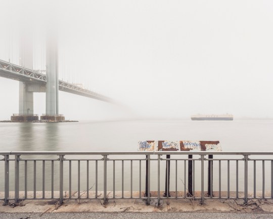
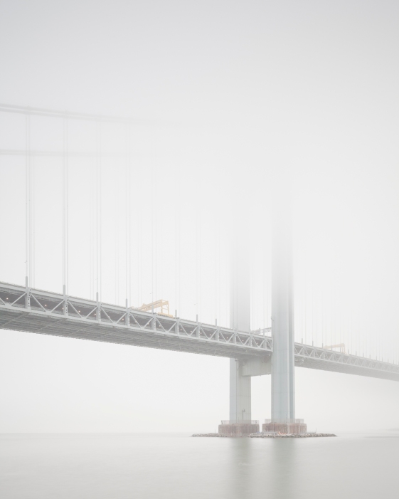
View of Staten Island obscured by fog, from Bay Ridge, Brooklyn.
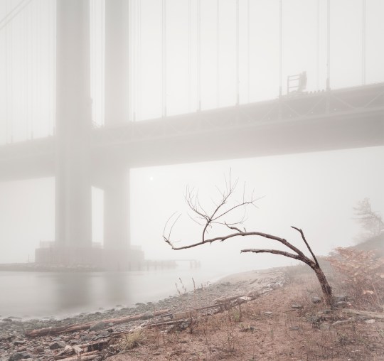
An early morning at Fort Wadsworth, on the opposite side of the span.

Inside the Brooklyn Army Terminal
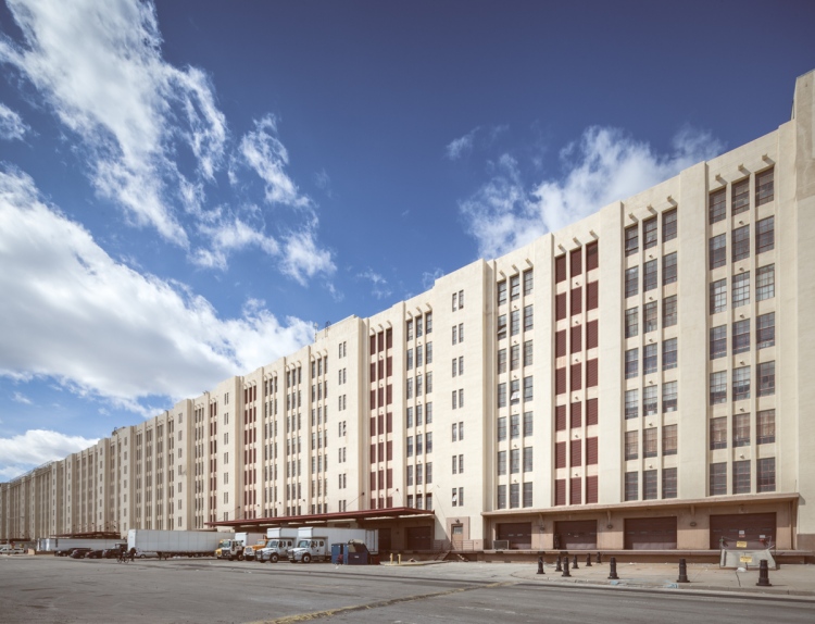
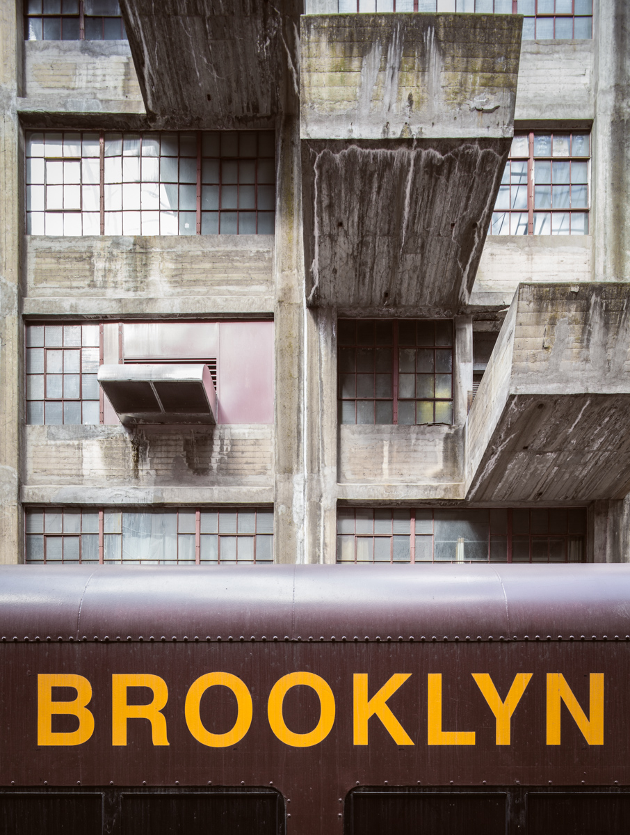
The Brooklyn Army Terminal’s Building B stretches toward the horizon.
Let me be the first to point out that the Brooklyn Army Terminal is far from abandoned. It’s actually one of the most vibrant hubs of industry remaining on a Brooklyn waterfront that was once dominated by factories, warehouses, and refineries, many of which have fallen into decay or been renovated into luxury condos. Along with the Brooklyn Navy Yard, the neighboring Bush Terminal, and nearby Industry City, the Army Terminal is proving every day that industry can not only survive, but thrive, on the Brooklyn waterfront.
I’m often asked why abandoned buildings in New York aren’t just turned into housing for the homeless, offered up to local artists, or repurposed as museums, and the truth is it’s never, ever that simple. But here’s an example of a historic building that has been painstakingly brought back from the brink of decay–over a period of 35 years with $150 million in public and private investment–to become a viable source of job creation. Luckily, the Brooklyn Army Terminal has managed to retain a palpable connection to its history, and in some areas, a pleasing patina of decay in keeping with its old age.
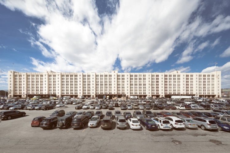
At almost 100 acres, the property covers the length of several city blocks.

The Terminal was the largest concrete building in the world at the time it was built.
Overall, the structure reflects the austerity and efficiency one might expect given its military origins, and sure enough, nearly every architectural embellishment turns out to serve a practical purpose. Seemingly decorative studs lining the top of the facade actually function as a simple but effective drainage system for the roof. It’s a testament to the genius of its architect that such a utilitarian building can attain such elegance. The designer, Cass Gilbert, is best known for masterminding some of New York’s most beautiful and ornate structures, like the iconic Woolworth Building or the majestic Customs House, not to mention the U.S. Supreme Court in Washington, DC.
The construction of the Brooklyn Army Terminal began in 1918 under the direction of the federal government, with the goal of establishing a more efficient means of dispatching supplies and personnel to military fronts around the world. The four million sq ft complex of warehouses, offices, piers, and railroads was built over a period of only 17 months. Though the First World War had ended by the time the structure was completed, the Terminal proved indispensable during WWII, employing over 20,000 military personnel and civilians. It acted as the headquarters of the New York Port of Embarkation, which collectively moved 3.2 million troops and 37 million tons of supplies to army outposts around the globe during the war. Hundreds of thousands of men passed through the terminal on their way to serve overseas, arriving by trains that dropped them off a few paces from the ramps of outgoing ships. The most famous visitor was Elvis Presley, who stayed longer than most, holding a press conference in front of a crowd of photographers, reporters, and fans before embarking on an 18 month tour of Germany in 1958. He had been drafted the previous year.

Restoration is progressing on a previously abandoned admin building.
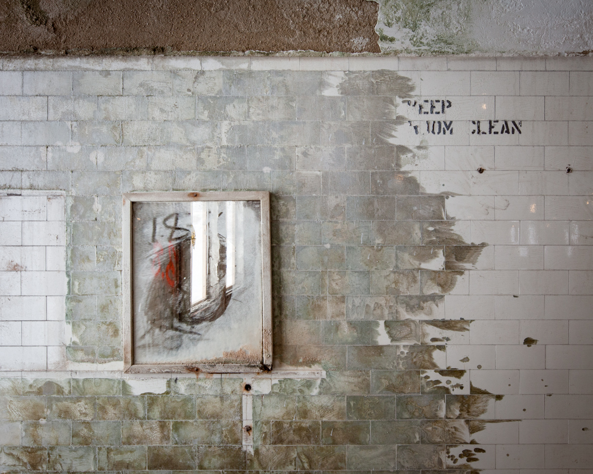
A bathroom mirror and friendly reminder left behind in the gutted interior.

Utility room on the roof of the annex.
The Terminal’s design was easily adapted to a variety of uses in peace time. During prohibition, it warehoused confiscated liquor from NYC speakeasies, and after the facility was decommissioned in 1966, the USPS moved operations into the ground floor following a fire in a prominent Manhattan branch. But through much of the 60s and 70s, the facility fell into a period of decay and decline. Ownership transferred to the city of New York in 1981, and the monumental task of restoring the structure for modern industrial use began in earnest when the NYC Economic Development Corporation stepped in to manage the building.
The job was split into discrete stages, tackling one section of the massive complex at a time. An upcoming renovation project dubbed “Phase 5” will complete the restoration of the two largest structures by revitalizing the last 500,000 sq ft of Building A, thanks to a $100 million dollar grant from the De Blasio administration announced last May. Today the leasable space boasts a 99% occupancy rate, with a diverse list of tenants including furniture builders, jewelry makers, and chocolatiers.
If you’re lucky enough to pay a visit, the highlight of the trip is Building B’s jaw-dropping atrium. (It’s generally closed to the public, but Turnstile Tours and Untapped Cities offer regular guided tours.) Freight cars would pull directly into the building and unload supplies with a five ton moveable crane that traveled the atrium from end to end, spanning the length of three football fields. Now the area serves as a walkway for tenants, and loading docks have been repurposed as balconies and container gardens. Recently, the location has been wildly popular for film and photo shoots, which is no surprise. It’s one of the most remarkable interiors in all of New York City.

The Brooklyn Army Terminal Atrium.
Loading platforms were staggered to allow the crane to access each level.

Vintage LIRR trains marooned on the tracks are just for show.

Platforms and railroad tracks run the length of the atrium.
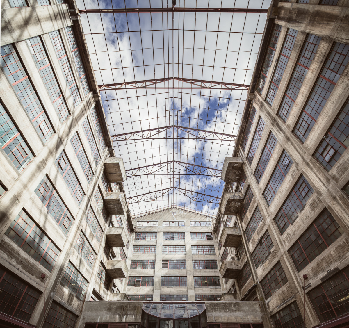
A glass ceiling was removed in the 1980s due to the high cost of maintenance.

Afternoon light penetrates the west wall of the atrium.
Book stuff is starting to wind down, but I do have a couple events on the horizon for anyone interested in attending. As always, you can pick up a signed copy directly through me at this website, it’s the best way to support what I do.
Coming Up:
Brooklyn Brainery, April 15th 8:30-10:00, $7(Sold Out)- Mid-Manhattan Library, May 7th, 6:30-8:00, Free!

A Last Look Inside a Demolished Staten Island Castle

In its final years, the Frost Memorial Tower of the old Smith Infirmary looked like the quintessential haunted house.
For 124 years, a castle with many names loomed over the quiet neighborhood of Thompkinsville, Staten Island. Perched on a six-acre hilltop covered in creeping vines, the striking red brick chateau could have been the backdrop of a fairy tale until thirty years of neglect made it the perfect setting for a Gothic horror. On an early March morning in 2012 while most of the island slept, wrecking balls converged at the Frost Memorial Tower of the old Samuel R. Smith Infirmary. In a matter of hours, the hospital was brought to the ground. Dozens gathered to watch her fall.

The stately Infirmary in its youth.

In 2011, the weight of winter snow caused the roof of the building to cave in. The same year, Hurricane Irene caused further damage, dashing any hope of saving the structure.
Today, the rubble-strewn lot is a symbol of lost history and lost hope for members of the Preservation League of Staten Island and their supporters, whose passionate and repeated efforts to save the building did little to sway the resolve of the Landmarks Preservation Commission. City engineers who inspected the structure confirmed that the building was in a state of progressive collapse, and would have proven a hazard to firefighters entering the building in the event of a blaze.
Some elements were salvaged prior to demolition.
Named for a doctor who dedicated his life to the treatment of the poor, the Samuel R. Smith Infirmary was founded in 1863 as the borough’s first private hospital. Principally funded by lavish charity balls, the organization was the pet project of the borough’s high society, known as the “Pride of Staten Island.” By the turn of the twentieth century, the Infirmary had outgrown its former home, and the cornerstone was laid for a new building, named the Frost Memorial Tower in honor of the wealthy benefactor who had gifted the hilly plot of land. It was destined to become one of Staten Island’s stateliest buildings.
A band of sunlight illuminates a doorway to ghostly effect.
Though the Smith Infirmary was established for the poor, it soon opened its doors to the general public and was renamed Staten Island Hospital in 1916. Many notable actors, lawyers, and political figures were treated there, among more mysterious cases. In 1907, an Infirmary doctor was murdered by the husband of a former patient who had passed away during an operation. The damning evidence that led to the man’s execution is still visible in Cypress Hills Cemetery. On his wife’s grave is the following epitaph: “Revenge renews our happy love in heaven forever.”

This grand staircase was the interior’s most striking feature.
By 1974, the once-rural land surrounding the complex had become densely populated, leaving little room for expansion. At the time, one hundred patients were waiting daily for admission, and parking had become a serious problem. The campus was abandoned in 1979 when the hospital relocated to a new building on Seaview Avenue.
By the turn of the 21st century, the property had accrued millions of dollars in tax liens, falling into an irreversible state of disrepair.
In 1983, the Landmarks Preservation Commission declined to designate the Smith Infirmary’s signature building despite its architectural and historical significance. In what had become a rough neighborhood, the derelict hospital quickly gained a reputation for illicit activities, and landmark status was likely to hamper redevelopment. The land was targeted early on for a series of residential development schemes that never came to fruition. As the building deteriorated, the property became a hotbed of real estate fraud and a haven for the neighborhood homeless, but many held fond feelings for the structure—locals called it “the Castle.”

At the time the infirmary was built, corners were thought to harbor germs, so many hospital rooms were designed with circular walls.
Through 33 years of abandonment, the degraded walls, slumping ceilings, and precarious floors of the Infirmary were utterly devastated by the elements. The smell of mold and rot permeated the interior. Wind blustered through its second floor landing, causing boards and debris to smack and rattle at odd intervals. These were the dying breaths of a squandered architectural treasure. Rest in pieces, Staten Island Castle.
Where a ceiling had collapsed on the top floor, walls gave way to open sky amid a mass of broken beams.
Getting Lost on North Brother Island

A tuberculosis pavilion crowns the treetops of North Brother Island like an Aztec ruin.
Most New Yorkers have never heard of North Brother Island, but they should take comfort in the fact that new trees are growing and manmade things are going by the wayside just a stone’s throw from Rikers and a few miles from LaGuardia Airport. New York City’s abandoned island proves that as much as we think we have a handle on things, nature is never far behind. Just give it time.

Many of the older structures are splitting at the seams, but there’s little hope or interest in preserving them.
In the case of North Brother Island, it took fifty years to transform a sparsely planted hospital campus to a bona fide wildlife sanctuary surging with fresh green life. Established as a city hospital for quarantinable diseases in 1885, it became a disreputable rehab center for adolescent drug addicts prior to its abandonment in the 1960s. To add to the intrigue, the island was the site of a catastrophic shipwreck and the residence of the notorious Typhoid Mary. (For a detailed history of Riverside Hospital, see Ian Ference’s thorough account over at the Kingston Lounge.) Today, opportunistic ivy floods the old lawns and races up the corners of the dormitories. Elsewhere, invasive kudzu—a Japanese import—holds at least an acre of land in its leafy grip. Few animals roam this untrodden landscape, with the exception of a handful of raccoons that took a dip in the East River and discovered the greenest place around.

An airplane takes off from nearby LaGuardia airport with a gantry crane in view.
Even though it’s one of the least inhabited places in New York City, you can still find pathways on North Brother Island. Parks employees and occasional visitors leave a network of rabbit trails on the forest floor, but they taper off on the south side, where a few ruins beckon you further into the weeds. I trudged through the brush for over an hour only to end up right back where I started, and it wouldn’t be the last time I was forced to admit defeat to the thorny wilds of Riverside Hospital. The island plays tricks on you, but it’s liberating to lose your way.

Surrealism made doubly surreal in a patient mural.
In order to protect the habitat and visitors from harm, North Brother Island is permanently closed to the public, and strictly off-limits during nesting season. Frequently patrolled due to its vicinity to Rikers, it’s known as one of the most difficult places in New York City to get to, which makes it an object of equal frustration and fascination for urban explorers near and far. (I was lucky enough to accompany a photographer with a long relationship with the Parks Department and a buddy with a boat—one or both are pretty essential if you’re trying to get here.)

The largest and most intriguing book I’ve ever seen was filled with the most mundane details.
If you never make it to North Brother Island, take heart in the fact that it’s best appreciated from afar, where distance allows the imagination to fill in the obscured reaches beneath its canopy and populate the crumbling towers visible on its shore. An abandoned island is the most natural thing in the world to romanticize, but in the light of day, the enigma dissolves. As menacing as the old buildings may appear, they’re ultimately indifferent.
But at day’s end, the sun slips low on the horizon and the ruins of Riverside Hospital begin to gleam. Our boat departs just as the light approaches a kind of golden splendor before winking into darkness. Receding from view as you near Barretto Point at sunset, North Brother Island regains a bit of its mystery. Come to think of it, no one’s ever been permitted to go there after dark…

Green leaves and blue skies illuminate a crumbling auditorium with jewel tones.

Inside the tuberculosis pavilion.

Metal barricades in an isolation room kept residents from breaking the windows.

Most of the hospital’s glass fixtures had been vandalized…

…but the island exhibits a near-complete lack of graffiti.

A spiral staircase in the former Nurses’ Residence.

Walls were stripped to their skeletons in this dormitory.

A doorway holds steady in a collapsed section of the Nurses’ Home, where a few saplings have taken root.
Green Thumbing Through the Boyce Thompson Institute

The abandoned Boyce Thompson Institute in Yonkers.
In 1925, Dr. William Crocker spoke eloquently on the nature of botany: “The dependence of man upon plants is intimate and many sided. No science is more fundamental to life and more immediately and multifariously practical than plant science. We have here around us enough unsolved riddles to tax the best scientific genius for centuries to come.”
As the director of the Boyce Thompson Institute in Yonkers, Crocker was charged with leading teams of botanists, chemists, protozoologists, and entomologists in tackling the greatest mysteries of the botanical world, focusing on cures for plant diseases and tactics to increase agricultural yields. The facility was opened in 1924 as the most well equipped botanical laboratory in the world, with a system of eight greenhouses and indoor facilities for “nature faking”—growing plants in artificial conditions with precise control over light, temperature, humidity, and carbon dioxide levels.

The sun sets on the greenhouses of the Boyce Thompson Institute.
The institution had been founded by Col. William Boyce Thompson, a wealthy mining mogul who became interested in the study of plants after witnessing starvation while being stationed in Russia, (although an alternate history claims he just loved his garden.) Recognizing the rapid rate of population growth worldwide, he sought to establish a research facility with an eye toward increasing the world’s food supply, “to study why and how plants grow, why they languish or thrive, how their diseases may be conquered and how their development may be stimulated.”
By 1974, the Institute had gained an international reputation for its contributions to plant research, but was beginning to set its sights on a new building. The location had originally been chosen due to its close proximity to Col. Thompson’s 67-room mansion Alder Manor, but property values had risen sharply as the area became widely developed. Soaring air pollution in Yonkers enabled several important experiments at the institute, but hindered most. With a dwindling endowment, the BTI moved to a new location at Cornell University in Ithaca, and continues to dedicate itself to quality research in plant science.

Most of the interiors had a near-complete lack of architectural ornament, but the entryway was built to impress.
The city purchased the property in 1999 hoping to establish an alternative school, but ended up putting the site on the market instead. A developer attempted to buy it in 2005 with plans to knock down the historic structures and build a wellness center, prompting a landmarking effort that was eventually shot down by the city council. The developer ultimately backed out, and the buildings were once again allowed to decay. Last November, the City of Yonkers issued a request for proposals for the site, favoring adaptive reuse of the existing facilities. Paperwork is due in January.
Until then, the grounds achieve a kind of poetic symmetry in warmer months, when wild vegetation consumes the empty greenhouses, encroaching on the ruins of this venerable botanical institute…
-Will Ellis

Ornate balusters made this staircase the most attractive area of the laboratory.

A central oculus leads to this mysterious pen in the attic.

This stone sphere had been the centerpiece of the back facade, until someone decided to push it down this staircase. See its original location here.

The city gave up on keeping the place secured long ago.

The north wing had been gutted at some point.

An interesting phenomenon in the basement–a population of feral cats had stockpiled decades worth of food containers left by well-meaning cat lovers.

A view from the upstairs landing was mostly pastoral 75 years ago.

The main building connects to a network of intricate greenhouses.

The interiors were covered with shattered glass, but still enchanting.
The Trapps Mountain Hamlet, Backwoods Ghost Town

A night at the 87 Motel in New Paltz.
If you’re like me, city living can wear you down—sooner or later, you’re itching for the woods again. The sleepy college town of New Paltz offers a cheap motel and a short proximity to Mohonk Preserve, 5,000 acres of hiking trails, swimming holes, and rock scrambles nestled deep in the ancient Palisades. The world-worn hills of the Shawangunk Ridge evoke a pleasing sense of permanence to the weary New Yorker, it’s a lifetime away from the teeming avenues of Manhattan. Time seems to stand still around here, but out in these tall timbers, the ruins of a 19th century ghost town hint at a lost way of life.
The area is known for its landmark luxury resort, the Mohonk Mountain House, which has been run by the same family since it opened in 1869. True to its Quaker roots, the hotel originally banned liquor, dancing, and card playing; until 2006, it couldn’t claim a bar, and you still won’t find a TV or radio in any of the $700 a night lodgings. It may sound old-fashioned, but it’s part of a tradition in these parts—since they were first settled in the late 1700s, things have always been behind the times.
The Fowler Burial Ground.
Before the age of mountain tourism, a small subsistence community lived off this land, growing what little food the thin, rocky soil could support, raising a handful of livestock, drinking from the Coxing and Peter’s Kills. They scraped a living carving millstone out of native rock, shaving barrel hoops, and harvesting tree bark for leather tanning. In the summer, women and children joined in harvesting huckleberries, a seasonal cash crop in wild abundance at the time.
With a peak population of forty or fifty families, the settlement included a hotel, a store, a chapel, and a one room schoolhouse. Despite this progress, the population held to its old ways. So hopelessly and wonderfully at odds with the changing values of the outside world, this oldfangled hamlet didn’t stand a chance.
Starting in the late 1800s, advances in technology gradually replaced the small trades of the Trapps. Unable to sell their traditional wares, settlers found work in neighboring resorts, including the Mohonk Mountain House, building hotels and maintaining trails and carriage roads. In the late 20s, the construction of Route 44 created a short term boom in the town’s employment, but eventually led to its decline.
Many sold their property to resort owners and headed to nearby villages to find a better way of life, but one man called Eli Van Leuven stayed behind, living in a tiny plank house without running water or electricity until his death in 1956.
The Van Leuven Cabin has been lovingly restored, an unassuming monument to a largely forgotten community. Aside from this, the humble industries of the two score families that resided here have left little to mark them but shallow depressions in the ground, rubble stacked in odd arrangements, and leaf-littered tombstones. Only a settlement so bound to the earth could disappear so completely.
On the drive home, the first sighting of the Manhattan skyline elicits a kind of dull horror, signaling the inevitable return to a concrete-bound existence. As I’m plunged back into the 21st century, the scene is at once overstimulating and shockingly mundane. In that moment, I’d take an axe and a cool morning in a mountain hamlet over any day in the ad-plastered streets of midtown, but the daydreams invariably dissolve. Out of habit, obligation, or common sense, I’ll forget the plank house for the brownstone, the Coxing Kill for the coffee shop, as the stony ruins of a mountain town blanket themselves in moss.
-Will Ellis

The Clearwater Ruins are some of the best preserved.

Former site of the Enderly House, most structures incorporated Native American techniques into their construction.

Unfinished work in the millstone quarry.

Path to the Van Leuven Cabin.

The fully restored cabin, constructed in 1889, is occasionally open for tour groups.

This road was built in large part by Trapps Hamlet residents. Today, it glides through the heart of the ghost town.

Route 44, the road to ruins.

This boundary wall was used to delineate the property of Benjamin Fowler, who owned 150 acres for farming, livestock, and family use.

Many of Benjamin’s young children are buried in this forest plot. This grave for his son William is the earliest, dating to 1866.

The motel pond by night.

Stadium proportions of a New Paltz grocery, a far cry from the corner bodega.

At Split Rock swimming hole.

Climbing to the top of Bonticou Crag.

In the nearby Minnewaska State Park, the Awosting Falls swells from a mid-August downpour.
Inside Fort Totten: Part 1

An abandoned battery at Fort Totten
Fort Totten sits on a far-flung peninsula of the Long Island Sound, forming the Northeast corner of Queens. The grounds of this defunct military installation turned underfunded public park are home to over 100 historic buildings representing a series of changes that have taken place over the area’s quiet 200 year history. Unfortunately, the majority of these stuctures have been disused for decades, and many are in a state of progressive collapse. With so much of Fort Totten closed off with caution tape, overtaken with vines, or hidden beneath rusty fences, it makes for an unconventional park, but a fascinating place to wander.
An 1829 farmhouse predating the land’s military use crumbles behind a weedy barricade; out front, a prominent sign bears the inscription: “Please Excuse My Appearance, I am a Candidate for Historical Preservation.” It’s an image that typifies the current state of affairs in the Fort Totten Historic District.
On the northern tip of Willet’s Point, a monumental granite fortification constructed during the Civil War as a key component of the defense of the New York Harbor sits unoccupied, though it’s used as a haunted house on occasion. Clustered on the rest of the grounds, dozens of dilapidated Romanesque Revival and Queen Anne Style officers’ quarters, hospitals, bakeries, movie theatres, and laboratories vie for restoration, but so far the funding has failed to materialize.

The Willet Farmhouse, Fort Totten’s oldest structure, and one of the most at risk.
One such building, a two-story YMCA facility built in 1926, has been abandoned for close to 20 years, but much of what’s left behind lies undisturbed. On a bulletin board in an upstairs landing, a 1995 thank-you letter from a kindergarten class at PS 201 hangs by a crude depiction of Santa Claus, both lovingly dedicated to an Officer Rivera. Steps away, in a rotting book room, an incongruous stash of 80s porno magazines.
Most recently used as a community relations unit of the New York City Police Department, the building is cluttered with mattresses, discarded packaging, and unopened toy donations. The New York City Fire Department, which now operates training facilities in a renovation abutting the hospital building, currently uses the attached gymnasium as a storage space. The basement was filled with rusted-through shelving and ruined equipment, flooded and too dark to shoot.

An overgrown pit in a World War I battery.
On the other side of the peninsula, a series of concrete batteries sit half-submerged in plant life. These were constructed at the turn of the century, but by 1938, they were declared obsolete and subsequently abandoned. The boxy design looks like modern architecture to me, but the battery reveals its true age in other ways.
Pencil-thin stalactites ornament the ceiling wherever the rain gets in, suspended over a crank-operated machine designed to lift heavy weaponry a century ago. The network of maze-like tunnels feature arched hallways with metal doors, winding staircases, and yawning pits, all fit for a dungeon. Guards stationed at the fort were laid off in 2009, and it was unclear on my visit if the area was open to the public or not. A rusty barrier, more hole than fence, didn’t keep out a couple of high school kids, but offered a spot for them to park their bikes.
When the military base changed hands in 2005 and became an official New York City Park, Bloomberg predicted that Fort Totten was “certain to become one of New York’s most popular parks.” Some community members feared that the estimated 450,000 yearly visitors would disrupt parking, increase crime, and change the face of the neighborhood, but ten years later, tourism has yet to pose a problem.
Fort Totten hasn’t lived up to its potential just yet, but the progress that has been made gives hope for improvements to come. The park now offers regular events and educational programs to draw visitors and enrich the surrounding community. Several nonprofit groups have occupied and renovated the decrepit buildings, including the landmarked Officers’ Club, which now serves the Bayside Historical Society as an educational facility and exhibition and event space. These are small but significant victories in the effort to save the historic legacy of a little-known plot that could be the crown jewel of Queens parkland.
(Though in some cases, it may be too little, too late. One look inside the profoundly decayed Fort Totten Army Hospital, in Part 2 of this post, will assure you of that.)
-Will Ellis
Related Links:
- Fort Totten Historic District Designation Report
- Fort Totten History from the Bayside Historical Society
- NYTimes 1999 “Fort Totten’s Old Houses are Tottering”
- NYTimes 2003 “Nearer to a Fort Totten Park but Not to a Consensus”
- Scouting NY—A Snowy Day at Fort Totten

This obscure Queens park doubles as a ghost town.

The YMCA building partially obscured by monstrous vegetation. On the left, a new renovation.

Inside, a rusty scale abandoned in the lobby.

An emptied snack bar once served concessions at sporting events and amateur theatre.

A community kitchenette still held pots, pans, and complete place settings.

A bulletin board on the second floor that hadn’t been updated in 17 years.

This room must have provided temporary housing to minors. The floor was littered with clothing and old English projects.

In the opposite corner, a derelict dollhouse. If I had been in the Twilight Zone, I’d have found a miniature me in there.

The remains of a rotting book room, which also housed a store of nudie magazines.

Through the library, a crumbling projection room overlooking the YMCA gymnatorium.

Daylight spills onto the practical planes of an underground battery.

Other areas had vaulted ceilings and arched double doors.

The interiors were almost completely empty, except for a dusting of dirt and leaf litter.

Some rooms held a few remnants…

Like this one: 100-year-old machinery in a dark Fort Totten nook.
The Harlem Renaissance Ballroom

Inside The Harlem Renaissance Ballroom
The dance floor of the Harlem Renaissance Ballroom sprouts mushrooms today, but 80 years ago it quaked with the frenzied rhythms of the Lindy Hop.
The Ballroom was completed in 1924 as part of a larger entertainment hub that included a bustling casino and 900-seat theatre. Built and operated by black businessmen, the “Rennie” was the only upscale reception hall available to African Americans at the time. Prize fights, concerts, dance marathons, film screenings, and stage acts were held at the Renaissance, along with elegant parties and meetings of the most influential social clubs and political organizations in Harlem. The community’s elite gathered to dance the Charleston and the Black Bottom to live entertainment by the most renowned jazz musicians of the age.
The nightspot even played host to the nation’s first all-black professional basketball team, also called the Harlem Renaissance, considered by some to be the best in the world in their day. On game nights, portable hoops were erected on the dance floor, converting the ballroom into a stadium. Following each game, almost invariably a victory for the Rens, a dance was held where players would mingle and jive with the choicest ladies of Harlem. The team barnstormed in towns across the country, playing exhibition games in which coveted matches with white teams drew the largest crowds. In their best season, the Renns set a record with 88 consecutive wins that has yet to be broken.

View of the ballroom’s ruined interior from the bandstand.
A year before construction on the ballroom was completed, the institution that would one day demolish the Renaissance Casino moved in next door. The Abyssinian Baptist Church was once the largest Protestant congregation in the country, and continues to prosper today, both as a religious institution and a driving force of change in the surrounding neighborhood. Established in 1989, its nonprofit arm, the Abyssinian Development Corporation, has invested over $500 million in community development, becoming the most influential social service and housing provider in Harlem.
The corporation currently rents all of its 1,200 units of housing to low-income families, is responsible for constructing Harlem’s first new high school in 50 years, and has attracted numerous supermarkets, department stores, and national retail chains to aid in the development of the neighborhood. Despite their success, Abyssinian’s dealings have brought controversy in recent years. Many of their low-income tenants accuse the organization of neglect, pointing to hundreds of standing violations in their residential buildings. Their vision of the “New Harlem” seems at odds with some long-term community members, who call their “progress” gentrification.
The ADC purchased the Renaissance property in 1991 with plans to renovate the site back to its historical role as a social hall and community space. In the intervening years, they introduced a new plan that diverges sharply from their traditional housing ventures. While a portion of the property will be utilized as a community center, only 20% of the residential units will be “affordable,” the rest of the 19-story construction will be set aside for luxury condominiums. In a Times quote, Executive Director Sheena Wright cites the necessity of bringing “diverse income levels” to the neighborhood as justification for the project; she asserts, convincingly, that “one should not relegate Harlem to housing just for the poor.”
The first stage of development involves the demolition of the theatre structure. Plans call for the preservation of the ballroom’s facade, but the interior is coming down. The project almost hit a roadblock in 2006 when the structure was pegged for a Landmarks Commission review, but the ADC exerted its political muscle to block the designation, enlisting big name supporters like former Mayor Dave Dinkins, Manhattan Borough President Scott Stringer, and the New York Landmarks Conservancy to voice their opposition. In the five years that have passed since the ADC overcame this obstacle, a bleak economic climate has forced them to put the project on hold. Abyssinian is currently pursuing investors for the project.

A spotlight falls on the ballroom once again.
The site of the former theatre is now an empty lot harboring a few disused construction vehicles, but contrary to some reports, the Renaissance Ballroom still stands, for now.
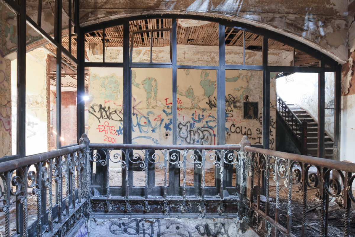
Most of the windows are boarded up, but light finds its way through a caved-in ceiling, exposing the diaphanous remnants of a golden age—colored light bulbs still lodged in the nightclub’s chandeliers, seat numbers pinned in the balcony. Ghostly images of jazz singers and blasting trombones barely cling to the proscenium of the ballroom’s weathered stage, once graced by Duke Ellington, Count Basie, and Ella Fitzgerald. The sense of history here is palpable, and the deterioration absolute. Reduced to mulch, the dance floor supports a thriving green fungal colony. Little points to the existence of a casino on the lower floor, but a coatroom remains largely intact. The rest gives the impression of a war zone—feral cats tread freely over piles of rubble that once delineated rooms. It’s easy to see why Spike Lee used this location as a nightmare crack den in Jungle Fever.
Langston Hughes had the Rennie in mind when he described “a golden girl, in a golden gown, in a melody night, in Harlem town.” It’s been decades since the “mellow magic of dancing sound” has reverberated here, but the Ballroom remains significant through its connection to the cultural and intellectual movement it nurtured.

The floor of the ballroom was significantly decayed.

One of the larger mushroom patches.

Can you spot the face beaming on these faded signs?

Box seats in the balcony of the Harlem Renaissance Ballroom.

Another view from the stage.

Walls collapse in the downstairs lobby.

A dark hallway on the first floor.

The Coat Room
Top Posts & Pages

