AbandonedNYC
Will Ellis
Inside The Domino Sugar Refinery

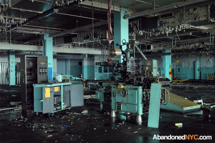
Inside the abandoned Domino Sugar Refinery’s cavernous raw sugar warehouse.
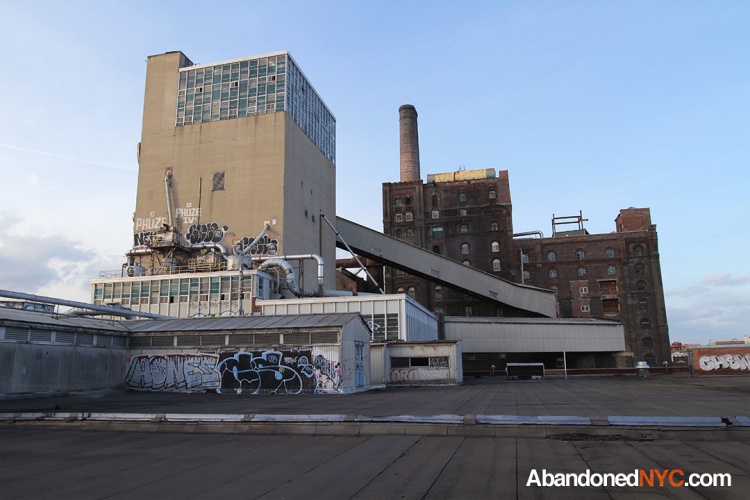
Situated on an eleven-acre parcel of waterfront in the shadow of the Williamsburg Bridge, the derelict Domino Sugar Refinery remains one of the most recognized monuments of Brooklyn’s rapidly disappearing industrial past. Now, after a decade of false starts, new plans for a modern, mixed use megacomplex may put an end to the decaying colossus that was once the largest refinery in the world, marking the final passage of a working-class Williamsburg.
In the late 19th century, Brooklyn was responsible for over half of the country’s sugar production, with Havemeyers & Elders Sugar Company leading the pack of over 20 major refineries that called the borough home. The factory’s signature building—a towering redbrick structure that still stands today—was constructed in 1884 to replace an older sugarhouse that had been destroyed in a catastrophic fire. Three years later, 17 of the largest sugar refiners in the U.S. merged to form the Sugar Refineries Co. Trust, later reorganized as the American Sugar Refining Co., and branded as Domino Sugar in 1902. Domino and its predecessors operated on the waterfront for a total of 148 years; at its peak, the site employed over 5,000 workers, capable of producing over three million pounds of processed sugar a day.

The American Sugar Refinery Processing House shown after its completion in the 1880s.
With the growing use of high fructose corn syrup and artificial sweeteners came a steady decline in demand for old-fashioned cane sugar. Production at the Williamsburg plant ended in the early 2000s with partial packaging operations lingering until 2004. The non-profit Community Preservation Corporation purchased the Domino site the same year for $58 million. Their plan would preserve and renovate the central refinery building, landmarked in 2007, and raise a battalion of architecturally offensive residential high-rises in the footprint of the surrounding industrial complex, razing the Raw Sugar Warehouse, constructed in 1927, and the Packaging House, a 1962 addition, in the process.

The old “New Domino” complex.
Two Trees teamed up with noted NYC firm SHoP Architects—the group is already leaving a lasting impression on the city landscape with the Barclay’s Center and the East River Esplanade. Unveiled Friday, their monumental plans seem tailor-made to appease the new population of Williamsburg, without limiting profits.
The plan is similar in scope to the vision of the CPC, with several key improvements. The buildings rise higher—up to 60 stories—to allow for more park space, including a one-acre “Domino Square,” where builders envision film screenings and outdoor concerts. Some of the structures include open spaces and sky bridges, an innovative solution sought to preserve harbor views for the inland community. The landmarked refinery building would be preserved and converted to office space, and several pieces of machinery would be salvaged for inclusion in a public “artifact walk.” In the face of such monumental changes, this may be of some consolation to New York nostalgics.

The new rendering.
Developers are working with the YMCA to establish a community space on the site, and are also proposing a new public school. Street level retail would favor independent business over chain store tenants. Two Trees also intends to deliver on the previous developer’s promise of 660 units of “affordable” housing, though the condition was never legally binding.
With all these benefits, Two Trees is attempting to pacify a community that is weary of change, and concerned for its future. The Domino development marks a clear and dramatic manifestation of a contentious transition that’s been taking place in Williamsburg for the last decade. The area is well known today as an infamous haven for hipster youth, but 10 years ago the neighborhood was a quiet, working-class community of Jewish, eastern European, and Hispanic immigrants. Now, it won’t be long before the tattooed and the trendy are priced out, leaving room for only the wealthiest New Yorkers. Emerging across formerly affordable areas of Manhattan and Brooklyn, the familiar pattern is destined to change the face of our city. Call it progress or gentrification. Praise the plans, or lament the loss, there’s no stopping the reckless growth of New York City.
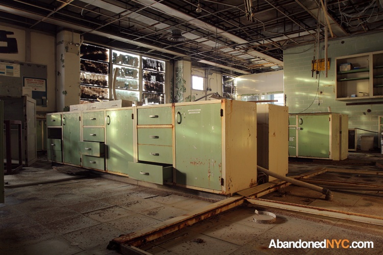
Eerie interiors of the abandoned packaging plant.
In its final moments, the Domino Sugar Refinery slips further into a speedy decay, introducing an element of the exotic to an already unfamiliar environment. Some of the alien interiors are coated with shallow puddles of tar, or dark sugar byproducts rendered the consistency of glue, or apple crisp. Others take on the appearance of an Egyptian temple in the impenetrable darkness, with row upon row of columns supporting the chasm of a vacant warehouse. Tinged aquamarine, the peeling factory floors of the packaging plant might be confused for the barnacled mechanisms of a sunken ship. The complex is unnervingly immense, presenting a seemingly endless series of floors connected by lightless, labyrinthine staircases. Alone in a factory that once employed thousands, up against its unfathomable depths, it felt like being in the belly of the whale—it didn’t take a miracle to get me out of there.
The next time you ride down the FDR or traverse the Williamsburg Bridge, take a good look at the sprawling industrial giant that was the Domino Sugar Refinery; it won’t be long before it’s preened and polished into the marketably modern new New Domino—another of the city’s rough edges, smoothed over in favor of gleaming glass.
A storage room in the soon to be demolished packaging house.
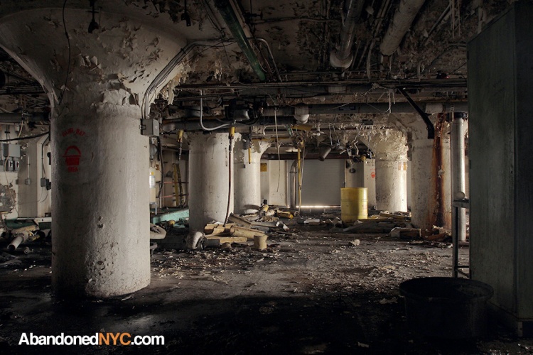
A dilapidated loading bay in the Domino Sugar Refinery.
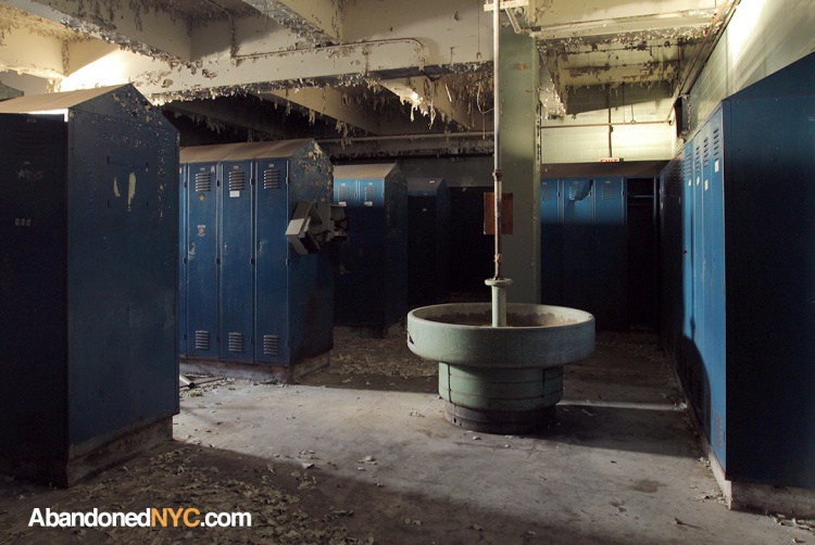
This locker room looked like something out of a horror movie.
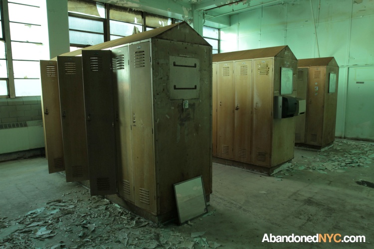
A smaller (women’s?) locker room.
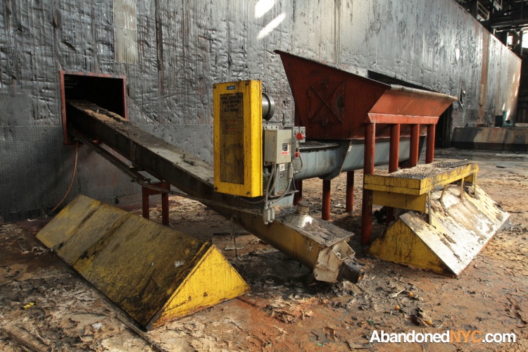
Machinery in the colossal Raw Sugar Warehouse.
An eyewash station.

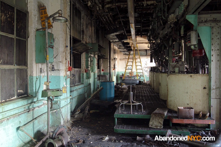
The factory interior.
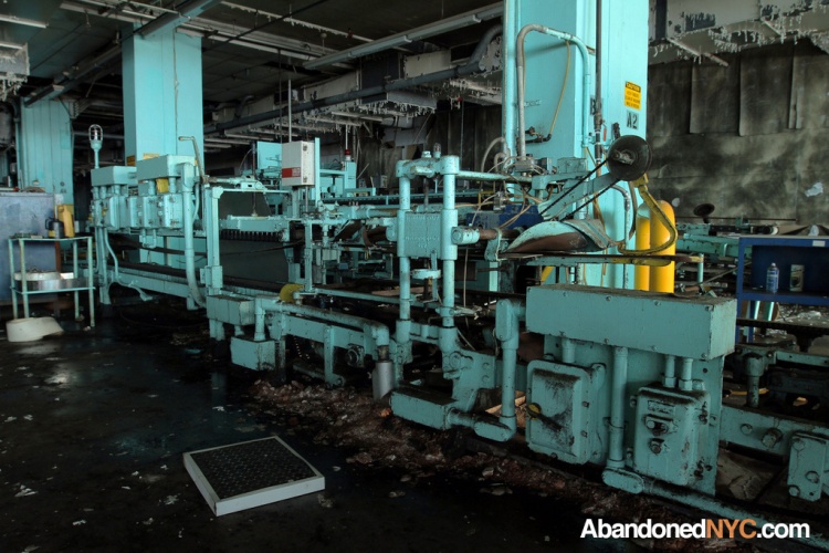
Another view of the packaging plant.
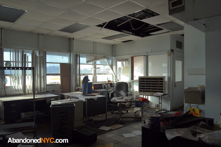
An emptied office overlooking the East River.
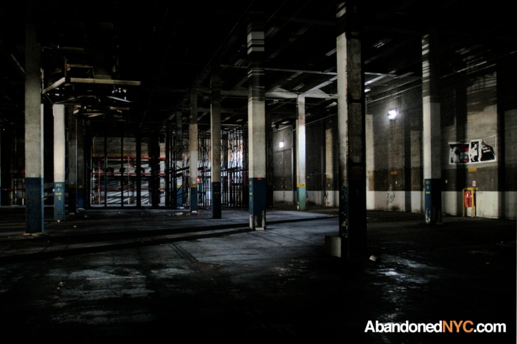
This warehouse was pitch black to the naked eye.
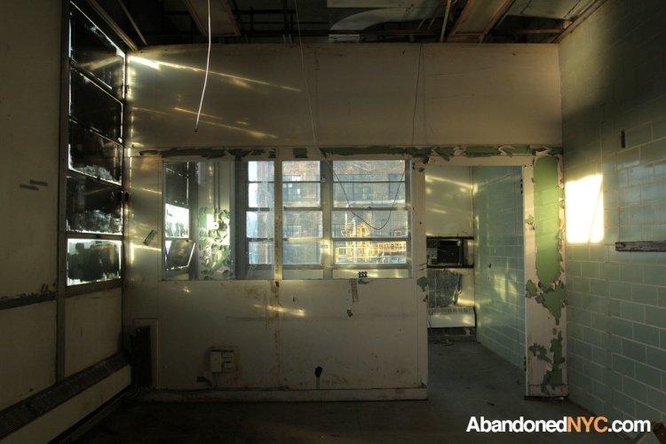
Evening light streaks through a painted window.
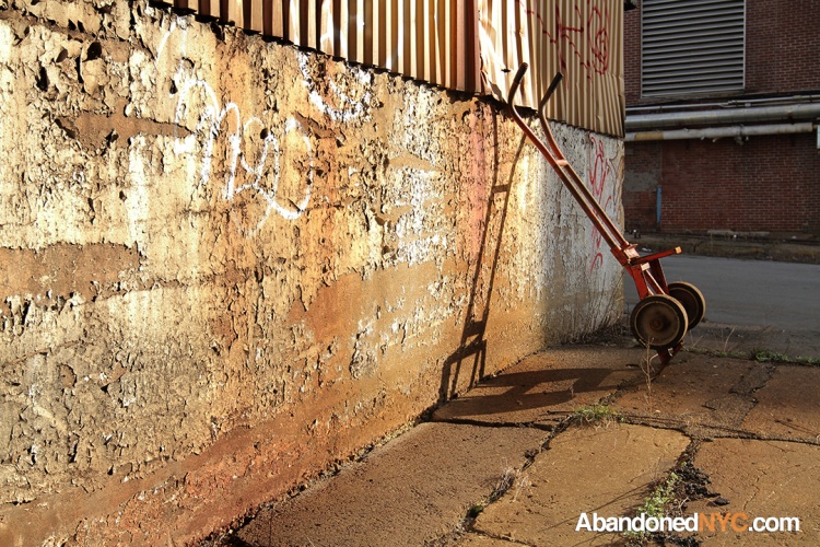
This handtruck might have sat untouched for a decade.
A view of the complex from the roof of the packaging plant.
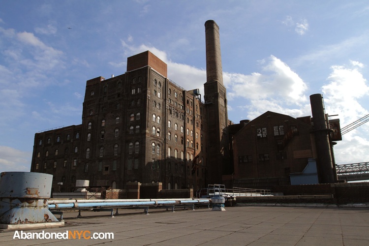
The landmarked refinery building as it stands today.

Bayley Seton Hospital: Part II

Flooded Hall.
I wasn’t able to track down any information on the function of this obscure outbuilding of the Bayley Seton Hospital complex in Stapleton, SI. The austere, three-story edifice is the only abandoned structure within the active section of Bayley Seton, situated on the northeast corner of the grounds behind the main building. The rest are fenced off and awaiting demolition after being sold to make way for a new development—it’s likely that this building may hang on for a bit longer.
For a detailed history of Bayley Seton Hospital, refer to my last post on the Nurses’ Residence.
If you have any information on this building, please enlighten me in the comments below.
- 2009 SI Live Article—”Salvation Army Finalizes Deal…”
- Photoessay by Nathan Kensinger on BSH’s Victim Services building
- Wikipedia entry on Bayley Seton Hospital

My favorite room in Bayley Seton Hospital.

Another view of the Utility Room. This door fell out of the wall when I tried to open it.

Evening light penetrates a dark hallway.

A crumbling passageway.

The floor of this room was covered with a rank, pulpy, mush—apparently the remains of ceiling panels that had gone to rot.

Glass block windows installed on the first floor.

One of several pieces of furniture remaining in the building.

A toilet with a strange weighted contraption.

An examination chair tucked away in the stairwell.

Graffiti in the building was minimal, but this bit stood out.

The building at sunset, just before a security guard asked me to leave…
The Bayley Seton Hospital Nurses’ Residence

Inside the Bayley Seton Hospital Nurses’ Residence
A floundering medical complex sits on a 20-acre campus in Stapleton on the North Shore of Staten Island. Today, eight of Bayley Seton Hospital’s twelve buildings lie abandoned, the largest being the old Nurses’ Residence at its southeast corner.
The grounds of BSH house Staten Island’s first hospital, an historic colonnaded structure built in the 1830s to serve ailing retired naval and merchant sailors, appropriately named “the Seamen’s Retreat.” Change came to the site in 1858 when a mob of 30-40 prominent locals attacked and burned down the Port of New York Quarantine Hospital, located a mile north of the Retreat. Though this horrific incident was incensed by an outbreak of yellow fever the locals blamed on the nearby hospital, flagrant racism was most likely a factor—recent immigrants made up the majority of the hospital’s population.
Some of the quarantine station’s services were transferred to areas of what is now Bayley Seton Hospital, and placed under the jurisdiction of the Marine Hospital Service, which by 1885 controlled the entire complex, and by 1902 had been renamed the US Public Health Service. In the 1930s, President Roosevelt started a campaign to revitalize The Public Health Service Hospitals, resulting in the construction of the main seven-story art-deco building and its offshoot Nurses’ Residence, a winged four-story structure on the southeast corner of the property.

The Nurses’ Residence (right,) pictured with the larger main building (left.)
The hospital was sold to the Sisters of Charity of New York, a Catholic healthcare organization, in 1980. At this point the U.S. Health Service Hospital was renamed after Sisters’ founder Elizabeth Seton and her father Richard Bayley (who coincidentally once headed the ill-fated Thompkinsville Quarantine Hospital.) Under the Sisters of Charity, the hospital was predominantly used to treat mental disorders and substance abuse, and continues to fulfill this role today, albeit at a greatly diminished capacity.
In 2000, The Sisters of Charity turned over Bayley Seton to the related Saint Vincent’s Catholic Medical Center, which faced financial troubles at the Stapleton campus from the beginning. Over half of its services were suspended and the hospital fell into an inexorable decline. Plans to close Bayley Seton emerged in 2004 as Saint Vincent’s, once the largest Catholic Health organization in New York, filed for bankruptcy with a debt of over a billion dollars. At some point during this tumultuous period (artifacts point to the building last being inhabited in 2002,) the former Nurses’ Residence, which had most recently been used as a New York addiction treatment facility, was abandoned as part of an ongoing series of downsizings and closures.

One of many gutted rooms, beginning to show signs of age.
In 2009, The Salvation Army settled on a 7.6 million dollar deal to purchase 7 acres of BSH. Originally, plans called for the construction of a 120,000 square-foot community center in the footstep of the Nurses’ Residence, set to begin in 2011, followed by a two-year period to terminate Bayley Seton’s remaining services, after which the main building would also be converted into senior housing. If it’s ever built, the center will be one of 30 similar complexes across the country funded by a 1.5 billion dollar endowment by the late Joan Kroc, widow of McDonald’s founder Ray Kroc. The Salvation Army failed to raise the 25 million needed to cover the difference between its cut of the Kroc endowment and the projected cost of construction, and ground has yet to be broken.

The Kroc Center in a 2007 rendering.
Twelve foot chain link fences have been placed along the perimeter of the Salvation Army property, but the site is otherwise untouched. Fenced-off and boarded-up, the Nurses’ Home ages in secret. Walls molt through layers of colored paint under tumbledown ceilings. The unrecognizable contents of a half-dozen milk cartons fester in a neglected refrigerator. An upright piano keeps mum in an empty common room while activity slows to a trickle on the rest of the Bayley Seton Hospital campus. Here and there, artifacts remain—painted crafts, motivational posters, hand-drawn cartoons—evoking the human element of the hospital’s better days. With its subtle architectural charms, the Nurses’ Residence has little hope of being saved from the wrecking ball, (though a few conservationists are out to change that.) Those in power seem to agree—despite centuries of convoluted history, it’s time to pull the plug on Bayley Seton Hospital.
For more photos of Bayley Seton Hospital’s abandonments, go on to PART II.
- 1858 NY Times Article on burning of quarantine buildings—”The Staten Island Arson”
- 2009 SI Live Article—”Salvation Army Finalizes Deal…”
- Photoessay by Nathan Kensinger on BSH’s Victim Services building
- Wikipedia entry on Bayley Seton Hospital

The main entrance.

Lettering here once pointed out the “Professional Services” office.

A kitchen on the top floor in the early stages of decay.

The contents of a staff-only refrigerator left long after their expiration dates.

This piano wasn’t worth the difficulty in transporting it.

Cheap ceilings crumble in the reception area.

Fluorescent fixtures dangle by the reception window.

Mold spreads on the walls of a first floor residence.

Another creepy hallway of the former Nurses’ Home.

“Invest in yourself, Share your pain”

Arts and Crafts

An exterior view of the abandoned Nurses’ Home as it stands today.
The Rockaway Beach Branch, Queens’ Forgotten Railroad

A platform still stands at Woodhaven Junction Station over Atlantic Avenue.
New York City’s narrowest jungle stretches across 3.5 miles of Central Queens, concealing the ruins of a rail line that’s been gathering rust for half a century. Abandoned by a bankrupt Long Island Railroad in 1962, the Rockaway Beach Branch is stirring debate today as opposing visions for its future emerge.
A passenger traveling on the Rockaway Beach Branch in the 1920s would board a southbound train at Whitepot Junction, pass through developing neighborhoods in Forest Hills, Glendale, Woodhaven, Richmond Hill, and Ozone Park, and traverse a burgeoning estuarine habitat called Jamaica Bay before arriving in the sandy Rockaways, then a popular vacation destination for privileged Manhattanites known as “New York’s Playground.” Today, the neighborhoods are flourishing, Jamaica Bay is losing 40 acres of marshland a year, and the isolated Rockaways are entering a stage of redevelopment.
The right-of-way was purchased by the city in the 1950s with plans to incorporate the entire line into its subway system, but the NYC Transit Authority ended up linking only the southern portion to the A train, cutting off the 3.5 mile stretch north of Rockaway Blvd. Through its 50 years of disuse, the remaining Rockaway Beach Branch has heard a stream of failed reuse and reactivation proposals as a forest has matured within its borders.
In 2005, community boards from Rego Park, Forest Hills, and other areas intersected by the line passed resolutions in favor of a linear park conversion, encouraged by the success of Manhattan’s High Line—a once abandoned rail line in Chelsea renovated into a futuristic above-ground park. According to the plan, bicycle paths and walkways would replace the derelict railroad, providing a much-needed green recreational space for the public. The Trust for Public Land is seeking private funding for a feasability study as a first step toward making the park, dubbed the “Queensway,” a reality. Beleaguered Rockaway commuters instead call for a reactivation of the line, which would provide a speedy link to Midtown Manhattan and a welcome alternative to the circuitous A-train. In response to this proposal, the MTA cites high operational and construction costs as deterrents to the project.
 Trudging through this palsied limb of the New York City transit system, it’s hard to imagine either plan coming to fruition here, a place where few people venture and fewer have a good reason to. Detritus from teenage excursions and midnight meetings collect in piles along the forgotten spur—scrapped car parts, a coil of barbed wire, scores of bottles, a forsaken shopping cart, and most memorably, a discarded cleaver.
In a different season, the century-old rails would be obscured by vegetation, but they’re clearly visible on this brisk February afternoon. Forty-year-old birch and oak reclaim the soil, shoving aside iron rails assembled in the 1910s. Fallen branches and debris intersect a continuous line of tracks; most electrical towers still stand, others lay mired in the overgrowth. Leaves crunching under my feet alert a chain of backyard sentinels to my presence. Aside from the dogs and the postman, little else stirs in this quiet residential community; change is coming to the Rockaway Beach Branch—but it could take another 50 years to arrive.


A jagged weapon discarded on an overpass.

A nearby substation abandoned by the LIRR.
A Watery Grave for Historic Ships on Staten Island

Wooden Shipwreck at Arthur Kill Boat Graveyard.
Do you know how to get to Staten Island’s most remarkable graveyard? First pass through a centuries-old roadside cemetery, (consisting of a handful of horribly eroded grave markers). Follow a barely there garbage-strewn path down to the marshy Arthur Kill (kill is the Dutch word for creek, which explains why creepy names like “Fresh Kills” abound in the Dutch-settled Hudson River Valley.) Once your feet are sinking a few inches into the mud with every step, you’ll start seeing the boats. Some over a century old, steam vessels, warships, ferries, fireboats, the final vestiges of New York’s shipping era, doomed to die here in a catastrophically polluted Staten Island waterway. Welcome to the Arthur Kill Boat Graveyard.

Secluded path from the cemetery down to the Arthur Kill.
Operational since the 1930s, Witte’s Marine Equipment company in Rossville served to dredge, salvage, and resell materials from the wrecked and disused vessels of the New York and New Jersey waterways. Eccentric owner John J. Witte refused to dismantle the majority of the ships that came to rest in the yard, amassing a prodigious collection of over 400 historic watercraft. As the ships slowly decomposed and the area gained a reputation as a mecca for artists and photographers, Witte gained his own reputation as a ferocious defender of his property, known for scaring off unsolicited visitors personally until he passed away in 1980. The yard is now controlled by the Donjon Marine Company, which seems to be taking a more proactive approach to actually salvaging materials from the wrecks and keeping the curious out, erecting 12-foot metal walls around the perimeter of the yard with signs prohibiting any and all photography.
The walls presented an obstacle, but after several muddy minutes I made it to the Arthur Kill Shore. Though the shipyard had lost most of its former glory, the remaining 20-40 wrecks were still an eldritch sight to behold—half submerged in years of muck, leaning at odd angles, corroded in streaks of rust, putrefying elbow to elbow with massive skeleton hulls. These wade out their final days in the boneyard before being stripped and recycled into automobiles and refrigerators. So see them while you can, if you dare, what was once the city’s premiere collection of nautical artifacts is sinking fast.

Rotting hulls jut from their shallow graves at the Arthur Kill Ship Graveyard.

Rusty Boats pile up on the shore.

Oxidized machinery adorns this decaying watercraft.

A salvaged wheelhouse moulders in the marsh.
Shedding Light on a Forgotten Red Hook Warehouse

Two stark, imposing sister buildings at 160 and 62 Imlay St. tower over the industrial wastes of Red Hook, Brooklyn. One recently renovated into a high-tech Christie’s storage facility for multi-million dollar works of art, the other a hulking, empty shell, waiting for a second life.
Constructed in 1911-13, the identical twin loft buildings on 160 and 62 Imlay St. began their lives as storehouses for the New York Dock Company. They made up a small part of a “globe-encircling commercial undertaking,” which included a sprawling network of 200 warehouses, 39 piers, and three ship-to-rail freight terminals extending over three miles of the Brooklyn Waterfront.
Rapidly declining profits and outdated infrastructure resulted in a cessation of operations in 1983. The buildings were purchased by a developer in 2000 and 2002 for a combined 22 million. In 2003, plans for a residential overhaul of 160 Imlay fell through as a result of a lawsuit from the local Chamber of Commerce, which sought to retain an industrial use for the property.
Now at 62 Imlay St, floors once flooded with tobacco and cotton are welcoming a new set of residents—multimillion dollar works of art by the likes of Van Gogh, Brancusi, and Pollack. The facility is leased by the high-profile auction house Christie’s and is equipped with “infrared video cameras, biometric readers and motion-activated monitors, as well as smoke-, heat- and water-detection systems.”
Adjacent sits the other sister with an uncertain future, its broad, vacant interiors shielded with plastic and shrouded in black netted scaffolding, gutted in preparation for a rumored second attempt at a residential conversion.


Top Posts & Pages

